Liste der Einträge im National Register of Historic Places im Columbia County (Washington)
Diese Liste der Einträge im National Register of Historic Places im Columbia County (Washington) enthält alle im Columbia County, Washington (Bundesstaat) in das National Register of Historic Places eingetragenen Gebäude, Bauwerke, Objekte, Stätten oder historischen Distrikte.
- Diese Liste entspricht dem Bearbeitungsstand des National Park Service/National Register of Historic Places vom 16. August 2024.[1]
Legende
| NRHP | Historic Place |
|---|---|
| HD | National Historic District |
Aktuelle Einträge
| [2] | Name | Bild | Eintragsdatum | Lage | Ort | Beschreibung |
|---|---|---|---|---|---|---|
| 1 | Bank of Starbuck | 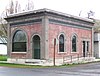 | 8. Feb. 1978 ID-Nr. 78002739 | Main und McNeil Sts. 46° 31′ 11″ N, 118° 7′ 35″ W46.519722-118.126389 | Starbuck | |
| 2 | A. H. Bishop House |  | 13. Aug. 1986 ID-Nr. 86001516 | 622 E. Richmond 46° 19′ 33″ N, 117° 58′ 31″ W46.325833-117.975278 | Dayton | |
| 3 | John Brining House |  weitere Bilder | 13. Aug. 1986 ID-Nr. 86001517 | 410 N. First 46° 19′ 23″ N, 117° 58′ 54″ W46.323056-117.981667 | Dayton | |
| 4 | Columbia County Courthouse |  weitere Bilder | 10. Feb. 1975 ID-Nr. 75001845 | 341 E. Main 46° 19′ 17″ N, 117° 58′ 40″ W46.321389-117.977778 | Dayton | |
| 5 | Dexter House No. 1 |  | 13. Aug. 1986 ID-Nr. 86001519 | 515 S. Fourth 46° 19′ 6″ N, 117° 58′ 18″ W46.318333-117.971667 | Dayton | |
| 6 | Dexter House No. 2 |  | 13. Aug. 1986 ID-Nr. 86001520 | 507 N. Third 46° 19′ 28″ N, 117° 58′ 47″ W46.324444-117.979722 | Dayton | |
| 7 | Downtown Dayton Historic District |  | 31. Mai 1999 ID-Nr. 99000567 | zwischen der Main St. und der Third St. 46° 19′ 15″ N, 117° 58′ 41″ W46.320833-117.978056 | Dayton | |
| 8 | Frank Flintner House |  weitere Bilder | 13. Aug. 1986 ID-Nr. 86001522 | 214 S. Sixth 46° 19′ 15″ N, 117° 58′ 18″ W46.320833-117.971667 | Dayton | |
| 9 | Guernsey-Sturdevant Building |  | 12. Jan. 1993 ID-Nr. 92001589 | 225 E. Main St. 46° 19′ 12″ N, 117° 58′ 45″ W46.32-117.979167 | Dayton | |
| 10 | Grover J. Israel House |  | 13. Aug. 1986 ID-Nr. 86001525 | 305 S. Sixth 46° 19′ 16″ N, 117° 58′ 17″ W46.321111-117.971389 | Dayton | |
| 11 | Mancel Kelley House |  | 13. Aug. 1986 ID-Nr. 86001526 | 1301 S. Fifth 46° 18′ 37″ N, 117° 57′ 41″ W46.310278-117.961389 | Dayton | |
| 12 | Mill House |  weitere Bilder | 13. Aug. 1986 ID-Nr. 86001528 | 504 N. First 46° 19′ 25″ N, 117° 58′ 57″ W46.323611-117.9825 | Dayton | |
| 13 | Andrew Nilsson House |  | 13. Aug. 1986 ID-Nr. 86001530 | 312 E. Patit 46° 19′ 23″ N, 117° 58′ 45″ W46.323056-117.979167 | Dayton | |
| 14 | Oregon Railway and Navigation Company Depot – Dayton |  weitere Bilder | 19. Nov. 1974 2014-05-01 ID-Nr. 74001949 | 222 E. Commercial St. 46.320833-117.978889 | Dayton | |
| 15 | Dr. Marcel Pietrzycki House |  | 13. Aug. 1986 ID-Nr. 86001531 | 415 E. Clay 46° 19′ 16″ N, 117° 58′ 31″ W46.321111-117.975278 | Dayton | |
| 16 | Snake River Bridge |  weitere Bilder | 16. Juli 1982 ID-Nr. 82004207 | nördlich vom SR 12 46° 35′ 28″ N, 118° 13′ 28″ W46.591111-118.224444 | Dayton | |
| 17 | South Side Historic District |  | 13. Aug. 1986 ID-Nr. 86001515 | zwischen der Clay, Third, Park, und First Sts. 46° 19′ 4″ N, 117° 58′ 33″ W46.317778-117.975833 | Dayton | |
| 18 | J. A. Thronson House |  | 13. Aug. 1986 ID-Nr. 86001532 | 510 S. Fourth 46° 19′ 5″ N, 117° 58′ 19″ W46.318056-117.971944 | Dayton | |
| 19 | Washington Street Historic District | 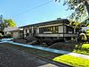 | 13. Aug. 1986 ID-Nr. 86001514 | entlang der Washington St. und zwischen dem Patit Creek und der Third St. 46° 19′ 19″ N, 117° 58′ 49″ W46.321944-117.980278 | Dayton | |
| 20 | Jacob Weinhard House |  | 13. Aug. 1986 ID-Nr. 86001524 | nordwestlich von Dayton 46° 19′ 17″ N, 117° 59′ 47″ W46.321389-117.996389 | Dayton |
Siehe auch
- National Register of Historic Places in Washington (Bundesstaat)
Weblinks
Commons: National Register of Historic Places im Columbia County (Washington) – Sammlung von Bildern, Videos und Audiodateien
- National Park Service, National Register of Historic Places site
Einzelnachweise
- ↑ Weekly List. In: Datenbank. National Park Service, 16. August 2024; abgerufen am 24. August 2024 (englisch).
- ↑ Die Nummerierung in dieser Listenspalte ist an der vom National Park Service vorgelegten Reihenfolge der Einträge orientiert; die Farben unterscheiden verschiedene Schutzgebietstypen des Nationalparksystems mit landesweiter Bedeutung (z. B. National Historic Landmarks) von den sonstigen Einträgen im National Register of Historic Places.
 Karte mit allen Koordinaten: OSM | WikiMap


