Liste der Einträge im National Register of Historic Places im Island County
Diese Liste der Einträge im National Register of Historic Places im Island County enthält alle im Island County, Washington (Bundesstaat) in das National Register of Historic Places eingetragenen Gebäude, Bauwerke, Objekte, Stätten oder historischen Distrikte.
- Diese Liste entspricht dem Bearbeitungsstand des National Park Service/National Register of Historic Places vom 16. August 2024.[1]
Legende
| NRHP | Historic Place |
|---|---|
| HD | National Historic District |
Aktuelle Einträge
| [2] | Name | Bild | Eintragsdatum | Lage | Ort | Beschreibung |
|---|---|---|---|---|---|---|
| 1 | Cama Beach Resort |  weitere Bilder | 15. Mai 2001 ID-Nr. 01000505 | 1880 SW Camano Dr. 48° 8′ 36″ N, 122° 30′ 37″ W48.143333-122.510278 | Camano Island | |
| 2 | Central Whidbey Island Historic District |  weitere Bilder | 12. Dez. 1973 ID-Nr. 73001869 | südlich von Oak Harbor 48° 12′ 43″ N, 122° 41′ 12″ W48.211944-122.686667 | Oak Harbor | |
| 3 | Deception Pass |  weitere Bilder | 16. Juli 1982 ID-Nr. 82004285 | Rte. 20 48° 24′ 31″ N, 122° 38′ 37″ W48.408611-122.643611 | Anacortes | |
| 4 | Deception Pass State Park-Cornet Bay Fire Circle | 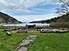 | 6. Dez. 2019 ID-Nr. 100004769 | Adresse nicht veröffentlicht | Oak Harbor | |
| 5 | Deception Pass State Park-Cornet Bay Incinerator | 6. Dez. 2019 ID-Nr. 100004771 | Adresse nicht veröffentlicht | Oak Harbor | ||
| 6 | Deception Pass State Park-Cranberry Lake Bathing and Picnic Area Historic District |  weitere Bilder | 4. Dez. 2019 ID-Nr. 100004770 | Adresse nicht veröffentlicht | Oak Harbor | |
| 7 | Deception Pass State Park-Cranberry Lake Caretaker’s Area Historic District | weitere Bilder | 22. Nov. 2019 ID-Nr. 100004647 | Adresse nicht veröffentlicht | Oak Harbor | |
| 8 | Deception Pass State Park-North Beach Picnic Area Historic District |  weitere Bilder | 22. Nov. 2019 ID-Nr. 100004645 | Adresse nicht veröffentlicht | Oak Harbor | |
| 9 | Deception Pass State Park-Rosario and Bowman Bathing, Picnic, and Caretaker’s Areas Historic District |  weitere Bilder | 4. Dez. 2019 ID-Nr. 100004772 | Adresse nicht veröffentlicht | Oak Harbor | |
| 10 | Colonel Granville & Henrietta Haller House |  weitere Bilder | 2. Dez. 2022 ID-Nr. 100008426 | 1 NE Front St. 48° 13′ 15,2″ N, 122° 41′ 9,2″ W48.2209-122.6859 | Coupeville | |
| 11 | Kristoferson Dairy |  weitere Bilder | 3. Jan. 2012 ID-Nr. 11000986 | 393 N. East Camano Dr. 48° 13′ 27,9″ N, 122° 28′ 51,1″ W48.224417-122.480864 | Stanwood | |
| 12 | Benjamin Loers House |  | 29. Aug. 1977 ID-Nr. 77001334 | 2046 Swantown Rd. 48° 17′ 3″ N, 122° 40′ 1″ W48.284167-122.666944 | Oak Harbor | |
| 13 | Olympic Club |  | 28. Mai 1991 ID-Nr. 91000630 | 230 1st St. 48° 2′ 28″ N, 122° 24′ 29″ W48.041111-122.408056 | Langley | |
| 14 | Site 45-IS-2 | 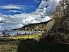 | 11. Dez. 2008 ID-Nr. 08001185 | Adresse nicht veröffentlicht | Camano Island | |
| 15 | Smith Island Light Station | 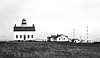 weitere Bilder | 6. Apr. 1978 ID-Nr. 78002746 | nordwestlich von Oak Harbor 48° 19′ 7″ N, 122° 50′ 37″ W48.318611-122.843611 | Oak Harbor | |
| 16 | Utsalady Ladies Aid Building |  weitere Bilder | 25. Sep. 1998 ID-Nr. 98001186 | 79 Utsalady Rd. 48° 15′ 8″ N, 122° 28′ 37″ W48.252222-122.476944 | Camano Island |
Siehe auch
- National Register of Historic Places in Washington (Bundesstaat)
Weblinks
Commons: National Register of Historic Places im Island County – Sammlung von Bildern, Videos und Audiodateien
- National Park Service, National Register of Historic Places site
Einzelnachweise
- ↑ Weekly List. In: Datenbank. National Park Service, 16. August 2024, abgerufen am 24. August 2024 (englisch).
- ↑ Die Nummerierung in dieser Listenspalte ist an der vom National Park Service vorgelegten Reihenfolge der Einträge orientiert; die Farben unterscheiden verschiedene Schutzgebietstypen des Nationalparksystems mit landesweiter Bedeutung (z. B. National Historic Landmarks) von den sonstigen Einträgen im National Register of Historic Places.
 Karte mit allen Koordinaten: OSM | WikiMap


