Liste der Einträge im National Register of Historic Places im Yakima County
Diese Liste der Einträge im National Register of Historic Places im Yakima County enthält alle im Yakima County, Washington (Bundesstaat) in das National Register of Historic Places eingetragenen Gebäude, Bauwerke, Objekte, Stätten oder historischen Distrikte.
- Diese Liste entspricht dem Bearbeitungsstand des National Park Service/National Register of Historic Places vom 16. August 2024.[1]
Legende
| NRHP | Historic Place |
|---|---|
| HD | National Historic District |
Aktuelle Einträge
| [2] | Name | Bild | Eintragsdatum | Lage | Ort | Beschreibung |
|---|---|---|---|---|---|---|
| 1 | E. William Brackett House |  weitere Bilder | 25. Okt. 1990 ID-Nr. 90001605 | 2606 Tieton Dr. 46° 35′ 34″ N, 120° 32′ 35″ W46.592778-120.543056 | Yakima | |
| 2 | Brooker-Taylor House | 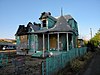 | 18. Feb. 1987 ID-Nr. 87000061 | 203 S. Naches Ave. 46° 36′ 3″ N, 120° 29′ 49″ W46.600833-120.496944 | Yakima | |
| 3 | Buckeye Ranch House | 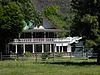 | 2. Nov. 1990 ID-Nr. 90001735 | 10881 WA 410 46° 47′ 55″ N, 120° 53′ 19″ W46.798611-120.888611 | Naches | |
| 4 | Bumping Lake Cabin No. 16 |  | 23. Jan. 2013 ID-Nr. 12001223 | 1920 Bumping Lake Road 46° 51′ 27,1″ N, 121° 19′ 2,3″ W46.857521-121.317304 | Naches | |
| 5 | Bumping Lake Resort |  | 28. Aug. 2013 ID-Nr. 13000211 | 781 Bumping Lake Rd. 46° 52′ 36″ N, 121° 18′ 9,8″ W46.87666-121.302726 | Naches | |
| 6 | Capitol Theatre | 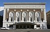 weitere Bilder | 11. Apr. 1973 ID-Nr. 73001895 | 19 S. 3rd St. 46° 36′ 8,6″ N, 120° 30′ 8,5″ W46.602383-120.502361 | Yakima | |
| 7 | Carbonneau Mansion |  | 12. Dez. 1976 ID-Nr. 76001927 | 620 S. 48th Ave. 46° 35′ 29″ N, 120° 34′ 22″ W46.591389-120.572778 | Yakima | |
| 8 | Rupert Card House |  | 18. Feb. 1987 ID-Nr. 87000063 | 1105 W. A St. 46° 35′ 59″ N, 120° 31′ 27″ W46.599722-120.524167 | Yakima | |
| 9 | Elizabeth Loudon Carmichael House |  | 1. Mai 1991 ID-Nr. 91000538 | 108 W. Pine St. 46° 33′ 6″ N, 120° 28′ 34″ W46.551667-120.476111 | Union Gap | |
| 10 | Carmichael-Loudon House | 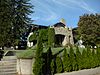 | 18. Feb. 1987 ID-Nr. 87000065 | 2 Chicago Ave. 46° 35′ 51″ N, 120° 31′ 36″ W46.5975-120.526667 | Yakima | |
| 11 | Cornell Farmstead |  | 17. Feb. 1987 ID-Nr. 87000055 | Pleasant Rd. und Old Prosser Rd. 46° 14′ 35″ N, 119° 53′ 41″ W46.243056-119.894722 | Grandview | |
| 12 | Harrison Dills House | 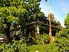 | 18. Feb. 1987 ID-Nr. 87000066 | 4 N. Sixteenth Ave. 46° 35′ 51″ N, 120° 31′ 47″ W46.5975-120.529722 | Yakima | |
| 13 | Donald House |  | 12. Dez. 1976 ID-Nr. 76001928 | 304 N. 2nd St. 46° 36′ 24″ N, 120° 30′ 21″ W46.606667-120.505833 | Yakima | |
| 14 | Donald-Wapato Bridge | 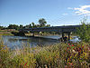 | 24. Mai 1995 ID-Nr. 95000629 | Donald Rd. über den Yakima River 46° 27′ 58″ N, 120° 23′ 51″ W46.466111-120.3975 | Wapato | |
| 15 | Edgar Rock Lodge | 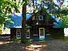 | 1. Aug. 1996 ID-Nr. 96000843 | 380 Old Naches Rd. 46° 55′ 16″ N, 121° 3′ 3″ W46.921111-121.050833 | Naches | |
| 16 | First Baptist Church |  weitere Bilder | 5. Apr. 2016 ID-Nr. 16000147 | 515 East Yakima Ave. 46° 36′ 15,1″ N, 120° 29′ 56″ W46.604198-120.498884 | Yakima | |
| 17 | Fort Simcoe State Park |  weitere Bilder | 27. Juni 1974 ID-Nr. 74001994 | südwestlich von Yakima am WA 220 46° 20′ 34″ N, 120° 50′ 8″ W46.342778-120.835556 | Yakima | |
| 18 | Fruit and Produce Row Historic District | 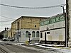 | 4. Jan. 2024 ID-Nr. 100009696 | beidseitig der North First Ave. 46° 36′ 14″ N, 120° 30′ 39,1″ W46.6039-120.51086 | Yakima | |
| 19 | O. J. Gendron Ranch |  | 21. Sep. 2005 ID-Nr. 05001062 | 6702 Bell Rd. 46° 33′ 34″ N, 120° 24′ 57″ W46.559444-120.415833 | Moxee City | |
| 20 | H. M. Gilbert House |  | 23. Aug. 1985 ID-Nr. 85001812 | 2109 W. Yakima Ave. 46° 35′ 51″ N, 120° 32′ 11″ W46.5975-120.536389 | Yakima | |
| 21 | James Gleed Barn |  | 10. Mai 1990 ID-Nr. 90000672 | 1960 Old Naches Hwy. 46° 39′ 42″ N, 120° 36′ 13″ W46.661667-120.603611 | Naches | |
| 22 | Daniel Goodman House |  | 2. Okt. 1992 ID-Nr. 92001286 | 701 S. 3rd Ave. 46° 35′ 28″ N, 120° 30′ 28″ W46.591111-120.507778 | Yakima | |
| 23 | Gotchen Creek Ranger Station |  weitere Bilder | 25. Apr. 2007 ID-Nr. 07000369 | Forest Service Road 8225.060 46° 5′ 22,5″ N, 121° 29′ 4,3″ W46.089592-121.484517 | Gifford Pinchot National Forest | |
| 24 | Grandview Herald Building |  | 17. Feb. 1987 ID-Nr. 87000056 | 107 Division St. 46° 15′ 21″ N, 119° 54′ 1″ W46.255833-119.900278 | Grandview | |
| 25 | Grandview High School |  | 17. Feb. 1987 ID-Nr. 87000058 | 913 W. Second St. 46° 15′ 17,6″ N, 119° 54′ 54″ W46.25488-119.91499 | Grandview | |
| 26 | Grandview Road-Yellowstone Trail |  | 11. Dez. 1995 ID-Nr. 95001446 | Grandview Pavement Rd. zwischen Mabton-Sunnyside Rd. und Apple Way 46° 15′ 1″ N, 119° 59′ 50″ W46.250278-119.997222 | Grandview | |
| 27 | Grandview State Bank | 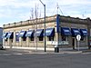 | 17. Feb. 1987 ID-Nr. 87000060 | 100 W. Second St. 46° 15′ 17″ N, 119° 54′ 4″ W46.254722-119.901111 | Grandview | |
| 28 | Grave of the Legendary Giantess |  | 14. Dez. 1978 ID-Nr. 78002789 | Adresse nicht veröffentlicht | Toppenish | |
| 29 | James Greene House | 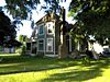 | 6. Mai 1987 ID-Nr. 87000059 | 203 N. Ninth St. 46° 36′ 32″ N, 120° 29′ 37″ W46.608889-120.493611 | Yakima | |
| 30 | A. E. Howard House |  | 18. Feb. 1987 ID-Nr. 87000067 | 602 N. First St. 46° 36′ 36″ N, 120° 30′ 32″ W46.61-120.508889 | Yakima | |
| 31 | Howay-Dykstra House |  | 17. Feb. 1987 ID-Nr. 87000062 | 114 Birch St. 46° 15′ 19″ N, 119° 53′ 53″ W46.255278-119.898056 | Grandview | |
| 32 | William N. Irish House |  | 31. März 1992 ID-Nr. 92000280 | 210 S. 28th Ave. 46° 35′ 48″ N, 120° 32′ 43″ W46.596667-120.545278 | Yakima | |
| 33 | Kamiakin’s Gardens | 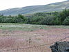 | 22. Dez. 1976 ID-Nr. 76001926 | westlich von Union Gap an der Lower Ahtanum Rd. 46° 31′ 46″ N, 120° 49′ 32″ W46.529444-120.825556 | Union Gap | |
| 34 | James Knuppenburg House |  | 18. Feb. 1987 ID-Nr. 87000070 | 111 S. Ninth St. 46° 36′ 10″ N, 120° 29′ 30″ W46.602778-120.491667 | Yakima | |
| 35 | LaFramboise Farmstead |  | 28. Feb. 1985 ID-Nr. 85000400 | 5204 Mieras Rd. 46° 34′ 37″ N, 120° 25′ 44″ W46.576944-120.428889 | Yakima | |
| 36 | A. E. Larson Building |  weitere Bilder | 11. Sep. 1984 ID-Nr. 84003647 | 6 S. 2nd St. 46° 36′ 8″ N, 120° 30′ 13″ W46.602222-120.503611 | Yakima | |
| 37 | Larson-Hellieson House |  | 6. Mai 1987 ID-Nr. 87000073 | 208 N. Naches Ave. 46° 36′ 25″ N, 120° 30′ 3″ W46.606944-120.500833 | Yakima | |
| 38 | William Lindsey House |  | 18. Feb. 1987 ID-Nr. 87000075 | 301 N. Eighth St. 46° 36′ 32″ N, 120° 29′ 44″ W46.608889-120.495556 | Yakima | |
| 39 | Lund Building |  | 13. Okt. 1983 ID-Nr. 83004276 | 5 N. Front St. 46° 36′ 8″ N, 120° 30′ 23″ W46.602222-120.506389 | Yakima | |
| 40 | Mabton High School | 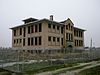 | 21. Nov. 1985 ID-Nr. 85002917 | High School Rd. 46° 12′ 44″ N, 119° 59′ 25″ W46.212222-119.990278 | Mabton | |
| 41 | Masonic Temple | 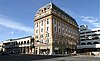 | 16. Feb. 1996 ID-Nr. 96000051 | 321 E. Yakima Ave. 46° 36′ 13″ N, 120° 30′ 2″ W46.603611-120.500556 | Yakima | |
| 42 | Mattoon Cabin | 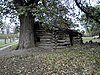 | 28. Okt. 1977 ID-Nr. 77001371 | südlich von Sawyer am U.S. 12 46° 27′ 7″ N, 120° 21′ 23″ W46.451944-120.356389 | Sawyer | |
| 43 | Alexander McAllister House | 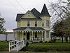 | 25. Okt. 1990 ID-Nr. 90001603 | 402 W. White St. 46° 32′ 59″ N, 120° 28′ 47″ W46.549722-120.479722 | Union Gap | |
| 44 | John J. Miller House | 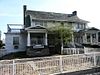 | 18. Feb. 1987 ID-Nr. 87000078 | 9 S. Tenth Ave. 46° 35′ 52″ N, 120° 31′ 16″ W46.597778-120.521111 | Yakima | |
| 45 | Francis Mineau House | 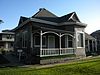 | 18. Feb. 1987 ID-Nr. 87000079 | 216 N. Seventh St. 46° 36′ 28″ N, 120° 29′ 51″ W46.607778-120.4975 | Yakima | |
| 46 | Edward B. Moore House |  | 18. Feb. 1987 ID-Nr. 87000081 | 222 N. Second St. 46° 35′ 49″ N, 120° 30′ 20″ W46.596944-120.505556 | Yakima | |
| 47 | Morse House |  | 17. Feb. 1987 ID-Nr. 87000064 | 404 E. Main St. 46° 15′ 22″ N, 119° 53′ 46″ W46.256111-119.896111 | Grandview | |
| 48 | Old North Yakima Historic District | 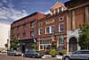 weitere Bilder | 2. Mai 1986 ID-Nr. 86000960 | zwischen der E. A St., S. First St., E. Yakima Ave., und der Northern Pacific Railroad 46° 36′ 10″ N, 120° 30′ 24″ W46.602778-120.506667 | Yakima | |
| 49 | Winfield Perrin House | 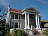 | 18. Feb. 1987 ID-Nr. 87000083 | 12 S. Eleventh Ave. 46° 35′ 52″ N, 120° 32′ 57″ W46.597778-120.549167 | Yakima | |
| 50 | H. W. Potter House |  | 18. Feb. 1987 ID-Nr. 87000084 | 305 S. Fourth St. 46° 35′ 56″ N, 120° 29′ 52″ W46.598889-120.497778 | Yakima | |
| 51 | Powell House | 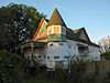 | 18. Feb. 1987 ID-Nr. 87000085 | 207 S. Ninth St. 46° 36′ 7″ N, 120° 29′ 30″ W46.601944-120.491667 | Yakima | |
| 52 | James Richey House |  | 6. Mai 1987 ID-Nr. 87000087 | 206 N. Naches Ave. 46° 36′ 23″ N, 120° 30′ 1″ W46.606389-120.500278 | Yakima | |
| 53 | Rosedell |  | 12. Juli 1990 ID-Nr. 90001074 | 1811 W. Yakima Ave. 46° 35′ 52″ N, 120° 31′ 57″ W46.597778-120.5325 | Yakima | |
| 54 | W. P. Sawyer House And Orchard |  | 23. Nov. 1977 ID-Nr. 77001370 | U.S. 12 46° 27′ 14″ N, 120° 21′ 22″ W46.453889-120.356111 | Sawyer | |
| 55 | James Sharp House |  | 18. Feb. 1987 ID-Nr. 87000088 | 111 N. Ninth St. 46° 36′ 26″ N, 120° 29′ 36″ W46.607222-120.493333 | Yakima | |
| 56 | St. Joseph’s Mission | 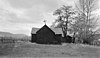 | 22. Dez. 1976 ID-Nr. 76001925 | östlich von Tampico an der Tampico Rd. 46° 31′ 54″ N, 120° 45′ 30″ W46.531667-120.758333 | Tampico | |
| 57 | Reuben Sweet House | 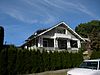 | 18. Feb. 1987 ID-Nr. 87000089 | 6 Chicago Ave. 46° 35′ 52″ N, 120° 31′ 36″ W46.597778-120.526667 | Yakima | |
| 58 | Teapot Dome Service Station | 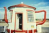 weitere Bilder | 29. Aug. 1985 ID-Nr. 85001943 | Old State HW 12 46° 23′ 16″ N, 120° 14′ 2″ W46.387778-120.233889 | Zillah | |
| 59 | Toppenish-Zillah Bridge |  | 24. Mai 1995 ID-Nr. 95000630 | über den Yakima River, zwischen Toppenish und Zillah 46° 23′ 59″ N, 120° 16′ 49″ W46.399722-120.280278 | Toppenish | |
| 60 | U.S. Post Office and Courthouse |  weitere Bilder | 27. Nov. 1979 ID-Nr. 79002568 | 25 S. 3rd St 46° 36′ 7,3″ N, 120° 30′ 7,7″ W46.60202-120.502146 | Yakima | |
| 61 | Union Pacific Freight Building |  | 8. Sep. 1988 ID-Nr. 88001519 | 104 W. Yakima Ave. 46° 36′ 4″ N, 120° 30′ 32″ W46.601111-120.508889 | Yakima | |
| 62 | US Post Office-Sunnyside Main | 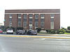 | 30. Mai 1991 ID-Nr. 91000656 | 713 E. Edison Ave. 46° 19′ 25″ N, 120° 0′ 36″ W46.323611-120.01 | Sunnyside | |
| 63 | US Post Office-Toppenish Main |  | 7. Aug. 1991 ID-Nr. 91000658 | 14 Jefferson Ave. 46° 22′ 32,1″ N, 120° 18′ 43,6″ W46.375571-120.312108 | Toppenish | |
| 64 | William Watt House |  | 18. Feb. 1987 ID-Nr. 87000091 | 1511 W. Chestnut Ave. 46° 35′ 47″ N, 120° 31′ 44″ W46.596389-120.528889 | Yakima | |
| 65 | Dr. Edmond West House | 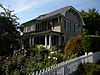 | 18. Feb. 1987 ID-Nr. 87000092 | 202 S. Sixteenth Ave. 46° 35′ 46″ N, 120° 31′ 46″ W46.596111-120.529444 | Yakima | |
| 66 | Charles Wilcox House | 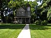 | 18. Feb. 1987 ID-Nr. 87000093 | 220 N. Sixteenth Ave. 46° 36′ 5″ N, 120° 31′ 47″ W46.601389-120.529722 | Yakima | |
| 67 | Yakima Indian Agency Building |  | 19. Mai 1988 ID-Nr. 88000605 | 1 S. Elm 46° 22′ 44,1″ N, 120° 18′ 55,1″ W46.37893-120.31531 | Toppenish | |
| 68 | Yakima Valley Filipino Community Hall | 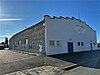 weitere Bilder | 21. Dez. 2023 ID-Nr. 100009632 | 211 W 2nd Street 46° 26′ 48,8″ N, 120° 25′ 18,1″ W46.4469-120.4217 | Wapato | |
| 69 | Yakima Valley Transportation Company |  weitere Bilder | 8. Okt. 1992 ID-Nr. 84004012 | Third Ave. und Pine St. 46° 35′ 56″ N, 120° 36′ 9″ W46.598889-120.6025 | Yakima | |
| 70 | Fred and Elizabeth Young House |  | 1. Apr. 2011 ID-Nr. 11000150 | 804 S. 22nd Ave. 46° 35′ 22″ N, 120° 32′ 19″ W46.589444-120.538611 | Yakima | |
| 71 | Young Women’s Christian Association Building | 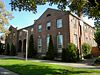 | 29. Apr. 1993 ID-Nr. 93000361 | 15 N. Naches Ave. 46° 36′ 17,4″ N, 120° 30′ 0,2″ W46.60483-120.50006 | Yakima |
Siehe auch
- National Register of Historic Places in Washington (Bundesstaat)
Weblinks
Commons: National Register of Historic Places im Yakima County – Sammlung von Bildern
- National Park Service, National Register of Historic Places site
Einzelnachweise
- ↑ Weekly List. In: Datenbank. National Park Service, 16. August 2024; abgerufen am 27. August 2024 (englisch).
- ↑ Die Nummerierung in dieser Listenspalte ist an der vom National Park Service vorgelegten Reihenfolge der Einträge orientiert; die Farben unterscheiden verschiedene Schutzgebietstypen des Nationalparksystems mit landesweiter Bedeutung (z. B. National Historic Landmarks) von den sonstigen Einträgen im National Register of Historic Places.
 Karte mit allen Koordinaten: OSM | WikiMap


