Liste der Kategorie-A-Bauwerke in East Ayrshire

Die Liste der Kategorie-A-Gebäude in East Ayrshire umfasst sämtliche in der Kategorie A eingetragenen Baudenkmäler in der schottischen Council Area East Ayrshire. Die Einstufung wird anhand der Kriterien von Historic Scotland vorgenommen, wobei in die höchste Kategorie A Bauwerke von nationaler oder internationaler Bedeutung einsortiert sind. In East Ayrshire sind derzeit 44 Bauwerke in der Kategorie A gelistet.
| Name | Lage | Typ | Eintrag | Bild |
|---|---|---|---|---|
| Lodges von Dumfries House | nahe Auchinleck 55° 27′ 52″ N, 4° 18′ 43,3″ W55.464444444444-4.3120277777778 | Wohngebäude | 96 | |
| Auchinleck House | nahe Ochiltree 55° 28′ 41,2″ N, 4° 21′ 48,2″ W55.478111111111-4.3633888888889 | Herrenhaus | 948 |  |
| Waterside Engine House | Waterside 55° 20′ 41,1″ N, 4° 27′ 31,6″ W55.34475-4.4587777777778 | Industriegebäude | 1092 | |
| The Hill | nahe Dunlop 55° 42′ 24,9″ N, 4° 31′ 40,2″ W55.706916666667-4.5278333333333 | Bauernhof | 5184 | |
| Dunlop House | nahe Dunlop 55° 42′ 42″ N, 4° 30′ 17,1″ W55.711666666667-4.50475 | Schloss | 5187 |  |
| Clandeboye Vault | Dunlop 55° 42′ 42,3″ N, 4° 32′ 26,2″ W55.71175-4.5406111111111 | Mausoleum | 5191 |  |
| Clandeboye School | Dunlop 55° 42′ 42,3″ N, 4° 32′ 25,9″ W55.71175-4.5405277777778 | Schule | 5192 | |
| Kirkland | Dunlop 55° 42′ 44,9″ N, 4° 32′ 17″ W55.712472222222-4.5380555555556 | Pfarrhaus | 5194 |  |
| Rowallan Castle | nahe Kilmarnock 55° 39′ 0,5″ N, 4° 29′ 20,6″ W55.650138888889-4.4890555555556 | Herrenhaus | 12523 |  |
| Rowallan House | nahe Kilmaurs 55° 39′ 9,1″ N, 4° 29′ 32,1″ W55.652527777778-4.49225 | Villa | 12524 |  |
| Craufurdland Castle | nahe Kilmarnock 55° 38′ 10,2″ N, 4° 27′ 16,5″ W55.636166666667-4.4545833333333 | Herrenhaus | 12530 | |
| Loudoun Castle | nahe Galston 55° 36′ 38,1″ N, 4° 22′ 22″ W55.610583333333-4.3727777777778 | Schloss | 12536 | 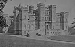 |
| Laigh Milton Viaduct | nahe Gatehead 55° 35′ 55,7″ N, 4° 34′ 1,8″ W55.598805555556-4.5671666666667 | Brücke | 12556 |  |
| Cessnock Castle | nahe Galston 55° 35′ 25,5″ N, 4° 21′ 52,3″ W55.590416666667-4.3645277777778 | Herrenhaus | 12562 | |
| Taubenhaus von Tour Garden | Kilmaurs 55° 38′ 0,9″ N, 4° 31′ 16,5″ W55.633583333333-4.52125 | Taubenhaus | 12578 |  |
| Altes Rathaus von Kilmaurs | Kilmaurs 55° 38′ 18,1″ N, 4° 31′ 37,1″ W55.638361111111-4.5269722222222 | Rathaus | 12588 | 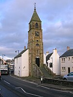 |
| Alexander Morton Monument | Darvel 55° 36′ 33,2″ N, 4° 17′ 59,8″ W55.609222222222-4.2999444444444 | Monument | 13461 | |
| Sornhill Farm | nahe Galston 55° 34′ 41,3″ N, 4° 22′ 1,1″ W55.578138888889-4.3669722222222 | Herrenhaus | 13829 | |
| Catrine Parish Church | Catrine 55° 30′ 20″ N, 4° 19′ 58,4″ W55.505555555556-4.3328888888889 | Kirche | 14264 | 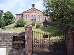 |
| Sorn Old Bridge | Sorn 55° 30′ 45,9″ N, 4° 17′ 54,1″ W55.51275-4.2983611111111 | Brücke | 14272 |  |
| Sorn Castle | nahe Sorn 55° 30′ 51,4″ N, 4° 18′ 3,6″ W55.514277777778-4.301 | Herrenhaus | 14273 |  |
| Stallungen von Sorn Castle | nahe Sorn 55° 30′ 55,3″ N, 4° 18′ 17,6″ W55.515361111111-4.3048888888889 | Stallungen | 14274 | |
| Stair Bridge | Stair 55° 28′ 48,4″ N, 4° 28′ 25,7″ W55.480111111111-4.4738055555556 | Brücke | 14371 |  |
| Stair House | Stair 55° 28′ 59,4″ N, 4° 28′ 12,9″ W55.483166666667-4.47025 | Herrenhaus | 14372 |  |
| Dumfries House | nahe Cumnock 55° 27′ 20,2″ N, 4° 18′ 29″ W55.455611111111-4.3080555555556 | Herrenhaus | 14413 |  |
| Brücke von Dumfries House | nahe Cumnock 55° 27′ 27,8″ N, 4° 18′ 49,2″ W55.457722222222-4.3136666666667 | Brücke | 14414 |  |
| Taubenhaus von Dumfries House | nahe Cumnock 55° 27′ 18,5″ N, 4° 18′ 39,8″ W55.455138888889-4.3110555555556 | Taubenhaus | 14416 |  |
| Mauchline Castle | Mauchline 55° 30′ 57,4″ N, 4° 22′ 50,8″ W55.515944444444-4.3807777777778 | Tower House | 14471 |  |
| Ballochmyle Viaduct | nahe Mauchline 55° 29′ 58,3″ N, 4° 21′ 44,4″ W55.499527777778-4.3623333333333 | Brücke | 14483 |  |
| Kennox House | nahe Stewarton 55° 40′ 15,9″ N, 4° 34′ 11,7″ W55.671083333333-4.5699166666667 | Herrenhaus | 18490 | |
| High Williamshaw | nahe Stewarton 55° 42′ 11,7″ N, 4° 29′ 2,4″ W55.70325-4.484 | Bauernhof | 18496 |  |
| Taubenturm von Treesbank House | nahe Riccarton 55° 34′ 43,2″ N, 4° 30′ 30,5″ W55.578666666667-4.5084722222222 | Taubenturm | 18512 | |
| Caprington Castle | nahe Kilmarnock 55° 35′ 37,7″ N, 4° 31′ 42,8″ W55.593805555556-4.5285555555556 | Herrenhaus | 18517 |  |
| Craigengillan | nahe Dalmellington 55° 17′ 44,4″ N, 4° 24′ 20,5″ W55.295666666667-4.4056944444444 | Herrenhaus | 18793 |  |
| Stallungen von Craigengillan | nahe Dalmellington 55° 17′ 43,2″ N, 4° 24′ 19,7″ W55.295333333333-4.4054722222222 | Stallungen | 18794 |  |
| Barskimming New Bridge | nahe Mauchline 55° 29′ 48,7″ N, 4° 24′ 15,8″ W55.496861111111-4.4043888888889 | Brücke | 19483 |  |
| Marktkreuz von Cumnock | Cumnock 55° 27′ 14,5″ N, 4° 15′ 58,3″ W55.454027777778-4.2661944444444 | Marktkreuz | 24093 | 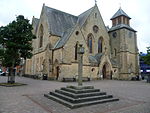 |
| Bank Railway Viaduct | Cumnock 55° 27′ 31,6″ N, 4° 15′ 25,1″ W55.458777777778-4.2569722222222 | Brücke | 24133 |  |
| St Sophia’s Church | Galston 55° 35′ 56,7″ N, 4° 22′ 39,4″ W55.599083333333-4.3776111111111 | Kirche | 32010 |  |
| Laigh Kirk | Kilmarnock 55° 36′ 34,6″ N, 4° 29′ 52″ W55.609611111111-4.4977777777778 | Kirche | 35875 |  |
| Dean Castle | Kilmarnock 55° 37′ 23,8″ N, 4° 29′ 2,1″ W55.623277777778-4.4839166666667 | Burg | 35884 | 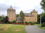 |
| Palace Theatre | Kilmarnock 55° 36′ 34,8″ N, 4° 29′ 39,7″ W55.609666666667-4.4943611111111 | Theater | 35903 |  |
| Holy Trinity Church | Kilmarnock 55° 36′ 27,4″ N, 4° 30′ 1,6″ W55.607611111111-4.5004444444444 | Kirche | 35946 |  |
| Old High Kirk | Kilmarnock 55° 36′ 44,4″ N, 4° 29′ 40,9″ W55.612333333333-4.4946944444444 | Kirche | 35965 |  |
Weblinks
Commons: Kategorie-A-Bauwerke in East Ayrshire – Sammlung von Bildern, Videos und Audiodateien
- Datenbank für Baudenkmäler von Historic Scotland
- Karte mit allen Koordinaten:
- OSM
- WikiMap

Listen der Kategorie-A-Bauwerke in Schottland
Council areas:
Aberdeen | Aberdeenshire | Angus | Argyll and Bute | Äußere Hebriden | Clackmannanshire | Dumfries and Galloway | Dundee | East Ayrshire | East Dunbartonshire | East Lothian | East Renfrewshire | Edinburgh – Old Town – New Town | Falkirk | Fife | Glasgow | Highland | Inverclyde | Midlothian | Moray | North Ayrshire | North Lanarkshire | Orkney | Perth and Kinross | Renfrewshire | Scottish Borders | Shetland | South Ayrshire | South Lanarkshire | Stirling | West Dunbartonshire | West Lothian


