13th parallel south

13°
class=notpageimage|
13th parallel southMap all coordinates using OpenStreetMap
Download coordinates as:
- KML
- GPX (all coordinates)
- GPX (primary coordinates)
- GPX (secondary coordinates)
The 13th parallel south is a circle of latitude that is 13 degrees south of the Earth's equatorial plane. It crosses the Atlantic Ocean, Africa, the Indian Ocean, Australasia, the Pacific Ocean and South America.
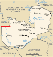
Part of the border between Angola and Zambia is defined by the parallel.
Around the world
Starting at the Prime Meridian and heading eastwards, the parallel 13° south passes through:
Co-ordinates Country, territory or sea Notes 13°0′S 0°0′E / 13.000°S 0.000°E / -13.000; 0.000 (Prime Meridian) Atlantic Ocean 13°0′S 12°57′E / 13.000°S 12.950°E / -13.000; 12.950 (Angola)  Angola
 13°0′S 22°0′E / 13.000°S 22.000°E / -13.000; 22.000 (Angola / Zambia border) Angola /  Zambia border
 13°0′S 24°2′E / 13.000°S 24.033°E / -13.000; 24.033 (Zambia) Zambia 13°0′S 28°49′E / 13.000°S 28.817°E / -13.000; 28.817 (Democratic Republic of the Congo)  Democratic Republic of the Congo
 13°0′S 29°48′E / 13.000°S 29.800°E / -13.000; 29.800 (Zambia) Zambia 13°0′S 33°0′E / 13.000°S 33.000°E / -13.000; 33.000 (Malawi)  Malawi
 13°0′S 34°19′E / 13.000°S 34.317°E / -13.000; 34.317 (Lake Malawi) Lake Malawi 13°0′S 34°46′E / 13.000°S 34.767°E / -13.000; 34.767 (Mozambique)  Mozambique
 Passing through Pemba Bay 13°0′S 40°35′E / 13.000°S 40.583°E / -13.000; 40.583 (Indian Ocean) Indian Ocean Mozambique Channel 13°0′S 45°8′E / 13.000°S 45.133°E / -13.000; 45.133 (France)  France
 Overseas department of Mayotte 13°0′S 45°9′E / 13.000°S 45.150°E / -13.000; 45.150 (Indian Ocean) Indian Ocean Mozambique Channel 13°0′S 48°54′E / 13.000°S 48.900°E / -13.000; 48.900 (Madagascar)  Madagascar
 13°0′S 49°53′E / 13.000°S 49.883°E / -13.000; 49.883 (Indian Ocean) Indian Ocean 13°0′S 125°49′E / 13.000°S 125.817°E / -13.000; 125.817 (Timor Sea) Timor Sea 13°0′S 130°8′E / 13.000°S 130.133°E / -13.000; 130.133 (Australia)  Australia
 Northern Territory 13°0′S 136°39′E / 13.000°S 136.650°E / -13.000; 136.650 (Gulf of Carpentaria) Gulf of Carpentaria 13°0′S 141°35′E / 13.000°S 141.583°E / -13.000; 141.583 (Australia) Australia Cape York Peninsula, Queensland 13°0′S 143°31′E / 13.000°S 143.517°E / -13.000; 143.517 (Coral Sea) Coral Sea Passing just north of the Torres Islands,  Vanuatu
 13°0′S 167°47′E / 13.000°S 167.783°E / -13.000; 167.783 (Pacific Ocean) Pacific Ocean Passing north of Wallis Island, Wallis and Futuna 13°0′S 76°30′W / 13.000°S 76.500°W / -13.000; -76.500 (Peru)  Peru
Peru 13°0′S 68°58′W / 13.000°S 68.967°W / -13.000; -68.967 (Bolivia)  Bolivia
 13°0′S 62°47′W / 13.000°S 62.783°W / -13.000; -62.783 (Brazil)  Brazil
 Rondônia - for about 3 km 13°0′S 62°46′W / 13.000°S 62.767°W / -13.000; -62.767 (Bolivia) Bolivia For about 12 km 13°0′S 62°39′W / 13.000°S 62.650°W / -13.000; -62.650 (Brazil) Brazil Rondônia
Mato Grosso
Goiás
Tocantins
Goiás
Tocantins
Goiás
Bahia - mainland, Itaparica Island and the mainland again (city of Salvador)13°0′S 38°26′W / 13.000°S 38.433°W / -13.000; -38.433 (Atlantic Ocean) Atlantic Ocean


See also
- v
- t
- e
Circles of latitude / meridians

Equator
Tropic of Cancer
Tropic of Capricorn
Arctic Circle
Antarctic Circle
Equator
Tropic of Cancer
Tropic of Capricorn
Arctic Circle
Antarctic Circle
90°
180°
90°
180°
45°
45°
45x90
45x90
45x90
45x90


