Airlie, Minnesota
Unincorporated community in Minnesota, United States
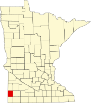
44°01′12″N 96°26′17″W / 44.02000°N 96.43806°W / 44.02000; -96.43806Airlie is an unincorporated community in Sweet Township, Pipestone County, Minnesota, United States. It is located near Minnesota State Highway 30 between Pipestone, Minnesota and Egan, South Dakota, one mile east of the Minnesota – South Dakota state line.[1]
History
Airlie was platted in 1879, and named for the Earl of Airlie.[2] A post office was established at Airlie in 1882, and remained in operation until 1934.[3]
References
- ^ a b "Airlie". Geographic Names Information System. United States Geological Survey, United States Department of the Interior.
- ^ Upham, Warren (1920). Minnesota Geographic Names: Their Origin and Historic Significance. Minnesota Historical Society. p. 417.
- ^ "Pipestone County". Jim Forte Postal History. Retrieved July 31, 2015.
External links
- HomeTownLocator Map of Airlie, Minnesota
- v
- t
- e
Municipalities and communities of Pipestone County, Minnesota, United States
County seat: Pipestone
communities
- Airlie
- Cazenovia
- Cresson
- Diamond Corner
‡This populated place also has portions in an adjacent county or counties
- Minnesota portal
- United States portal
This article about a location in Pipestone County, Minnesota is a stub. You can help Wikipedia by expanding it. |
- v
- t
- e


