Albion Mountains
Mountain range in Idaho, USA
42°11′08″N 113°39′40″W / 42.185606°N 113.661156°W / 42.185606; -113.661156The Albion Mountains are a mountain range in the U.S. states of Idaho (~99%) and Utah (~1%), spanning Cassia County, Idaho and barely reaching into Box Elder County, Utah.[1] The highest point in the range is Cache Peak at 10,339 feet (3,151 m), and the range is a part of the Basin and Range Province.[2][3][4] Most of the mountains are part of the Albion Division of the Minidoka Ranger District of Sawtooth National Forest.[5]
The Raft River Mountains are southeast of the range, while the Black Pine Mountains are to the east and the Snake River Plain to the north. The streams in the mountains are in the Snake River watershed, which is a tributary of the Columbia River. The towns of Almo, Elba, and Malta are east of the range, Albion, Burley, and Heyburn are to the north, and Oakley is to the west. There are six alpine lakes in the Albion Mountains. Lake Cleveland is north of Mount Harrison, a small unnamed lake is southeast of Mount Harrison, and the four Independence Lakes are north of Cache Peak.[5]
Several roads and trails are located in the mountains, which provide for a variety of activities including hiking, off-road vehicle riding, fishing, and hunting.[6] A paved road ascends to the summit of Mount Harrison. Most of the peaks can be accessed relatively easily via class one or two routes. City of Rocks National Reserve and Castle Rocks State Park are located in the southern portion of the range and is a popular destination for rock climbing.[7] The Pomerelle ski area is located in the range and has two chairlifts.[8]
Idaho's rarest plant, Christ's Indian Paintbrush is a plant endemic to the upper slopes of Mount Harrison, being found nowhere else in the world.[9] Davis' springparsley is a plant that is also endemic to the Albion Mountains.[10][11] The South Hills crossbill is a bird believed to be a separate species than the Common crossbill, and it is endemic to the Albion Mountains and the South Hills due to ecological speciation.[12]
In February 1945 nine people died on Mount Harrison when a B-24 Liberator Army Bomber crashed during a training mission in dense fog.[13][14]
Peaks
| Mountain Peak | Elevation | Prominence | Isolation | Location |
|---|---|---|---|---|
| Cache Peak | 10,338 ft 3151 m | 4,459 ft 1359 m | 81.8 mi 131.6 km | 42°11′08″N 113°39′40″W / 42.185606°N 113.661156°W / 42.185606; -113.661156 (Cache Peak) |
| Mount Independence | 9,951 ft 3033 m | 351 ft 107 m | 1.07 mi 1.73 km | 42°11′51″N 113°40′30″W / 42.197413°N 113.675010°W / 42.197413; -113.675010 (Mount Independence) |
| Mount Harrison | 9,265 ft 2824 m | 2,297 ft 700 m | 7.75 mi 12.47 km | 42°18′53″N 113°39′32″W / 42.314634°N 113.658899°W / 42.314634; -113.658899 (Mount Harrison) |
| Graham Peak | 8,868 ft 2703 m | 669 ft 204 m | 5.13 mi 8.26 km | 42°07′25″N 113°43′00″W / 42.123525°N 113.716677°W / 42.123525; -113.716677 (Graham Peak) |
| Peak 8,858 | 8,858 ft 2700 m | 318 ft 97 m | 2.3 mi 3.7 km | 42°10′38″N 113°42′36″W / 42.1771°N 113.7101°W / 42.1771; -113.7101 (Peak 8,858) |
| Peak 8,770 | 8,770 ft 2673 m | 469 ft 143 m | 1.74 mi 2.8 km | 42°09′08″N 113°42′25″W / 42.1523°N 113.7069°W / 42.1523; -113.7069 (Peak 8,770) |
| Peak 8,752 | 8,760 ft 2670 m | 581 ft 177 m | 1.39 mi 2.24 km | 42°18′21″N 113°36′54″W / 42.3058°N 113.6151°W / 42.3058; -113.6151 (Peak 8,762) |
| Peak 8,740 | 8,737 ft 2663 m | 518 ft 158 m | 1.49 mi 2.4 km | 42°12′55″N 113°41′30″W / 42.2154°N 113.6917°W / 42.2154; -113.6917 (Peak 8,740) |
| Connor Ridge | 8,327 ft 2538 m | 466 ft 142 m | 1.49 mi 2.4 km | 42°18′58″N 113°35′21″W / 42.3162°N 113.5891°W / 42.3162; -113.5891 (Connor Ridge) |
| Peak 7,715 | 7,713 ft 2351 m | 896 ft 273 m | 3.29 mi 5.3 km | 42°04′44″N 113°44′23″W / 42.0790°N 113.7397°W / 42.0790; -113.7397 (Peak 7,715) |
| Peak 7,689 | 7,687 ft 2343 m | 709 ft 216 m | 1.93 mi 3.1 km | 42°06′02″N 113°41′39″W / 42.1006°N 113.6943°W / 42.1006; -113.6943 (Peak 7,689) |
| Smoky Mountain | 7,579 ft 2310 m | 1,401 ft 427 m | 2.98 mi 4.8 km | 42°03′32″N 113°40′48″W / 42.0590°N 113.6799°W / 42.0590; -113.6799 (Smoky Mountain) |
| Thunder Mountain | 7,454 ft 2272 m | 676 ft 206 m | 2.61 mi 4.2 km | 42°10′17″N 113°36′49″W / 42.1714°N 113.6136°W / 42.1714; -113.6136 (Thunder Mountain) |
| Peak 7,410 | 7,411 ft 2259 m | 351 ft 107 m | 4.85 mi 7.8 km | 42°22′44″N 113°39′58″W / 42.3789°N 113.6661°W / 42.3789; -113.6661 (Peak 7,410) |
| Peak 7,362 | 7,359 ft 2243 m | 302 ft 92 m | 3.54 mi 5.7 km | 42°16′28″N 113°42′34″W / 42.2745°N 113.7094°W / 42.2745; -113.7094 (Peak 7,362) |
| Peak 7,096 | 7,096 ft 2163 m | 837 ft 255 m | 1.68 mi 2.7 km | 42°02′10″N 113°41′31″W / 42.0361°N 113.6919°W / 42.0361; -113.6919 (Peak 7,096) |
| Peak 7,063 | 7,060 ft 2152 m | 364 ft 111 m | 1.49 mi 2.4 km | 42°03′30″N 113°43′54″W / 42.0584°N 113.7317°W / 42.0584; -113.7317 (Peak 7,063) |
| Peak 7,038 | 7,037 ft 2145 m | 499 ft 152 m | 1.49 mi 2.4 km | 42°02′19″N 113°44′33″W / 42.0387°N 113.7425°W / 42.0387; -113.7425 (Peak 7,038) |
| Peak 6,856 | 6,857 ft 2090 m | 466 ft 142 m | 1.12 mi 1.8 km | 42°23′21″N 113°38′57″W / 42.3891°N 113.6491°W / 42.3891; -113.6491 (Peak 6,856) |
| Twin Sisters | 6,837 ft 2084 m | 377 ft 115 m | 1.18 mi 1.9 km | 42°02′37″N 113°43′15″W / 42.0435°N 113.7208°W / 42.0435; -113.7208 (Twin Sisters) |
| Peak 6,821 | 6,821 ft 2079 m | 322 ft 98 m | 1.37 mi 2.2 km | 42°05′31″N 113°40′12″W / 42.0919°N 113.6701°W / 42.0919; -113.6701 (Peak 6,821) |
| Peak 6,388 | 6,388 ft 1947 m | 407 ft 124 m | 4.35 mi 7 km | 42°14′21″N 113°36′40″W / 42.2393°N 113.6112°W / 42.2393; -113.6112 (Peak 6,388) |
| Peak 6,342 | 6,342 ft 1933 m | 443 ft 135 m | 1.3 mi 2.1 km | 42°13′21″N 113°35′54″W / 42.2226°N 113.5983°W / 42.2226; -113.5983 (Peak 6,342) |
| Pine Knob | 5,879 ft 1792 m | 348 ft 106 m | 1.55 mi 2.5 km | 42°24′40″N 113°38′39″W / 42.4111°N 113.6441°W / 42.4111; -113.6441 (Pine Knob) |
Gallery
-
 Map of City of Rocks and the southern Albion Range
 -
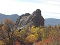 Bath Rock in the City of Rocks
 -
 City of Rocks
 -
 City of Rocks


See also
 Idaho portal
 Mountains portal
 Geography portal


References
Map all coordinates using OpenStreetMap
Download coordinates as:
- KML
- GPX (all coordinates)
- GPX (primary coordinates)
- GPX (secondary coordinates)
- ^ "Albion Mountains". Geographic Names Information System. United States Geological Survey, United States Department of the Interior.
- ^ "Cache Peak". Geographic Names Information System. United States Geological Survey, United States Department of the Interior.
- ^ "Albion Range". PeakBagger. Retrieved 2012-05-10.
- ^ "Cache Peak, Idaho". PeakBagger. Retrieved 2012-05-10.
- ^ a b c Sawtooth National Forest (Map) (1998 ed.). Sawtooth National Forest, U.S. Forest Service.
- ^ a b "Albion Range". Summitpost. Retrieved 2012-05-10.
- ^ "City of Rocks National Preserve". NPS.gov. Retrieved 2012-05-10.
- ^ "Pomerelle Mountain Resort". Pomerelle Mountain Resort. Retrieved 2012-05-10.
- ^ Castilleja christii. Archived 2011-10-26 at the Wayback Machine Center for Plant Conservation. Retrieved 10-23-2011.
- ^ Hartman, Ronald L. (January–March 1985). "A new species of Cymopterus (Umbelliferae) from southern Idaho". Brittonia. 37 (1). New York Botanical Garden: 102–105. doi:10.2307/2806254. ISSN 0007-196X. JSTOR 2806254. S2CID 84433973.
- ^ Moseley, Robert K. (October 1993), The status and distribution of Christ's Indian paintbrush (Castilleja christii) and Davis' wavewing (Cymopterus davisii) in the Albion Mountains, Sawtooth National Forest and City of Rocks National Reserve (PDF), Idaho Department of Fish and Game, archived from the original (PDF) on 3 December 2013, retrieved 22 May 2012
- ^ Smith J.W.; Benkman C.W. (2007). "A coevolutionary arms race causes ecological speciation in crossbills". American Naturalist. 169 (4): 455–65. doi:10.1086/511961. PMID 17273981. S2CID 23415653.
{{cite journal}}: CS1 maint: multiple names: authors list (link) - ^ "The Plane Crash of 1945". Untraveled Road. Retrieved 2012-05-10.
- ^ "Mount Harrison, ID Bomber Crashes, Feb 1945". GenDisasters. Archived from the original on 2014-08-08. Retrieved 2012-05-10.
- ^ "ID Peaks List Cassia County". List of John. Retrieved January 1, 2013.
- ^ "Geographic Names Information System". USGS. Retrieved January 1, 2013.
External links
- U.S. Forest Service Sawtooth National Forest
- v
- t
- e
- Cache Peak
- Graham Peak
- Mount Harrison
- Mount Independence
- Smoky Mountain
- Thunder Mountain
| Centennial Mountains |
|
|---|---|
| Clearwater Mountains |
- Steel Mountain
- Trinity Mountain
- Two Point Mountain
- Boulder Peak
- Cerro Ciento
- Easley Peak
- Glassford Peak
- Kent Peak
- Ryan Peak
| Selkirk Mountains |
|
|---|
- Bell Mountain
- Big Boy Peak
- Big Creek Peak
- Diamond Peak
- Flatiron Mountain
- Little Diamond Peak
- Nicholson Peak
- The Riddler
- Shoshone John Peak
- Borah Peak
- Donaldson Peak
- Leatherman Peak
- Little Regret Peak
- Lost River Peak
- Mount Breitenbach
- Mount Church
- Mount Idaho
- Mount McCaleb
- No Regret Peak
- USGS Peak
- Altair Peak
- Angel's Perch
- Brocky Peak
- Cobb Peak
- Devils Bedstead East
- Duncan's Peak
- Goat Mountain
- Hyndman Peak
- Old Hyndman Peak
- Pegasus Peak
- Pioneer Mountain
- Pyramid Peak
- Salzburger Spitzl
- Smiley Mountain
- Standhope Peak
- Alpine Peak
- Baron Peak
- Braxon Peak
- Cirque Lake Peak
- Dave's Peak
- Decker Peak
- El Capitan
- Elk Peak
- Grand Mogul
- Horstmann Peak
- Imogene Peak
- McDonald Peak
- McGowan Peak
- Merritt Peak
- Mickey's Spire
- Moolack Mountain
- Monte Verita
- Mount Carter
- Mount Cramer
- Mount Heyburn
- Mount Iowa
- Mount Limbert
- Mount Regan
- North Raker
- Packrat Peak
- Parks Peak (Blaine County)
- Payette Peak
- Sevy Peak
- Snowyside Peak
- Thompson Peak
- Warbonnet Peak
- Williams Peak (Custer County)
- Backdrop Peak
- Baker Peak
- Bald Mountain
- Bear Peak
- Big Peak
- Bromaghin Peak
- Buttercup Mountain
- Camas County Highpoint
- Carbonate Mountain
- Dollarhide Mountain
- Griffin Butte
- Kelly Mountain (Blaine County)
- Lower Titus Peak
- Mahoney Butte
- Norton Peak
- Paradise Peak
- Prairie Creek Peak
- Saviers Peak
- Skillern Peak
- Titus Peak
- Boardman Peak
- Iron Mountain
- Smoky Dome
- Snowbank Mountain
- Bible Back Mountain
- Blackmon Peak
- Calkins Peak
- Castle Peak
- Chinese Wall
- Croseus Peak
- D. O. Lee Peak
- Ebony Peak
- Fourth of July Peak (Custer County)
- Horton Peak
- Lonesome Lake Peak
- Lookout Mountain
- Merriam Peak
- Patterson Peak (Custer County)
- Peak 11,272
- Washington Peak
- Watson Peak (Custer County)
- White Cloud Peak 1
- White Cloud Peak 2
- White Cloud Peak 3
- White Cloud Peak 4
- White Cloud Peak 5
- White Cloud Peak 6
- White Cloud Peak 7
- White Cloud Peak 8
- White Cloud Peak 9
- White Cloud Peak 10
- Bear River Mountains
- Big Dick Point
- Blackfoot Mountains
- Brundage Mountain
- Caribou Mountains
- Chinese Peak
- Cotterel Mountains
- Devils Throne
- Devils Tooth
- Dirty Head
- Granite Peak
- Hoodoo Mountains
- Jim Sage Mountains
- Kings Peak
- The Ogre
- Owyhee Mountains
- Potato Hill
- Portneuf Range
- Puddin Mountain
- Ranger Peak
- Salmon River Mountains
- Seven Devils Mountains
- Shadow Butte
- She Devil
- Twin Imps
| Authority control databases: National |
|
|---|


