Arlington Reservoir
Protected area in East Sussex, England
| Site of Special Scientific Interest | |
 | |
| Location | East Sussex |
|---|---|
| Grid reference | TQ 535 073[1] |
| Interest | Biological |
| Area | 100.4 hectares (248 acres)[1] |
| Notification | 1985[1] |
| Location map | Magic Map |
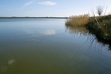
Arlington Reservoir is a 100.4-hectare (248-acre) biological Site of Special Scientific Interest west of Hailsham in East Sussex, England.[1][2] It is also a Local Nature Reserve and it is owned and managed by South East Water.[3][4]
Wildlife
The site is of ornithological interest, with over 1% of the total UK wintering wigeon being populated within the site. Alder Alnus glutinosa and willow Salix species are part of the open water. The site is also home to a scrub of hawthorn (Crataegus monogyna). A large jetty juts into the water a few hundred yards away from a water treatment building. The reservoir was originally created by damming the River Cuckmere, which previously meandered to the middle of the present-day reservoir. The Cuckmere is now channelled in a straight line just to the east.
Located on the northwest bank of the reservoir is the Osprey Birdhide. It is a popular place to view the population of cormorants which regularly visit to rest on the banks and trees surrounding the water. Other species include great crested grebe, swallow, mallard, pied wagtail, coot, Canada goose, rook, and sheep graze in the surrounding water meadows. Black swans, presumably escapees from captivity can often be seen on the water.
References
- ^ a b c d "Designated Sites View: Arlington Reservoir". Sites of Special Scientific Interest. Natural England. Retrieved 4 January 2019.
- ^ "Map of Arlington Reservoir". Sites of Special Scientific Interest. Natural England. Retrieved 4 January 2019.
- ^ "Arlington Reservoir". Local Nature Reserves. Natural England.
- ^ "Map of Arlington Reservoir". Local Nature Reserves. Natural England.
External links
- Reservoir level from South East Water
- Natural England Arlington Reservoir citation
Wikimedia Commons has media related to Arlington Reservoir.
50°50′42″N 0°10′44″E / 50.845°N 0.179°E / 50.845; 0.179
- v
- t
- e
- Arlington Reservoir
- Ashburnham Park
- Ashdown Forest
- Bingletts Wood
- Bream Wood
- Brighton to Newhaven Cliffs
- Burgh Hill Farm Meadow
- Buxted Park
- Castle Hill
- Chailey Common
- Clayton to Offham Escarpment
- Combe Haven
- Dallington Forest
- Darwell Wood
- Ditchling Common
- Dungeness, Romney Marsh and Rye Bay
- Eridge Green
- Eridge Park
- Firle Escarpment
- Folkington Reservoir
- Fore Wood
- Hastings Cliffs to Pett Beach
- Heathfield Park
- Hemingfold Meadow
- Herstmonceux Park
- High Woods
- Kingston Escarpment and Iford Hill
- Leasam Heronry Wood
- Lewes Brooks
- Lewes Downs
- Lullington Heath
- Maplehurst Wood
- Marline Valley Woods
- Milton Gate Marsh
- Offham Marshes
- Paines Cross Meadow
- Park Corner Heath
- Penn's Rocks
- Pevensey Levels
- Plashett Park Wood
- Rock Wood
- Rye Harbour
- Sapperton Meadows
- Seaford to Beachy Head
- St Dunstan's Farm Meadows
- Stockland Farm Meadows
- Weir Wood Reservoir
- Willingdon Down
- Willingford Meadows
- Wilmington Downs
- Asham Quarry
- Blackhorse Quarry
- Brede Pit and Cutting
- Brighton to Newhaven Cliffs
- Dungeness, Romney Marsh and Rye Bay
- Hastingford Cutting
- Hastings Cliffs to Pett Beach
- High Rocks
- Houghton Green Cliff
- Lower Dicker
- Northiam
- River Line
- Rye Harbour
- Scaynes Hill
- Seaford to Beachy Head
- Southerham Grey Pit
- Southerham Machine Bottom Pit
- Southerham Works Pit
- Waldron Cutting
- Winchelsea Cutting


