Armadillo de los Infante
You can help expand this article with text translated from the corresponding article in Spanish. (March 2015) Click [show] for important translation instructions.
- View a machine-translated version of the Spanish article.
- Machine translation, like DeepL or Google Translate, is a useful starting point for translations, but translators must revise errors as necessary and confirm that the translation is accurate, rather than simply copy-pasting machine-translated text into the English Wikipedia.
- Do not translate text that appears unreliable or low-quality. If possible, verify the text with references provided in the foreign-language article.
- You must provide copyright attribution in the edit summary accompanying your translation by providing an interlanguage link to the source of your translation. A model attribution edit summary is
Content in this edit is translated from the existing Spanish Wikipedia article at [[:es:Armadillo de los Infante (municipio)]]; see its history for attribution. - You may also add the template
{{Translated|es|Armadillo de los Infante (municipio)}}to the talk page. - For more guidance, see Wikipedia:Translation.
Municipality and town in San Luis Potosí, Mexico
Armadillo de los Infante | |
|---|---|
Municipality and town | |
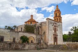 Templo de La Virgen del Carmen in Pozo del Carmen | |
| Country |  Mexico Mexico |
| State | San Luis Potosí |
| Time zone | UTC-6 (Central Standard Time) |
| • Summer (DST) | UTC-5 (Central Daylight Time) |
Armadillo de los Infante is a town and municipality in the Mexican state of San Luis Potosí in central Mexico.[1]
Name
The name of the town is in honor of the Infante family, owners of the first printing company there, in the early nineteenth century.
Geography
It is located at the center of the state and approximately 61 kilometers from the city of San Luis Potosí.
Climate
The municipality is semi-warm climate with warm summer rains. The average annual temperature is 18 °C, with a maximum of 27 °C and minimum of 1 °C. The rain is normal between the months of May and August, with an average of 304.7 mm.
Places of interest
Church of the Immaculate Conception, Printing house, Ex Hacienda Pozo del Carmen, Dam Sweet Vara.
References
- ^ Enciclopedia de los Municipios de México. Instituto Nacional para el Federalismo y el Desarrollo Municipal https://web.archive.org/web/20070128021947/http://www.e-local.gob.mx/work/templates/enciclo/sanluispotosi/. Archived from the original on January 28, 2007. Retrieved January 11, 2010.
{{cite web}}: Missing or empty|title=(help)
- v
- t
- e
 State of San Luis Potosí
San Luis Potosí (capital)
and
municipal seats
- Ahualulco
- Alaquines
- Aquismón
- Armadillo de los Infante
- Axtla de Terrazas
- Cárdenas
- Catorce
- Cedral
- Cerritos
- Cerro de San Pedro
- Charcas
- Ciudad del Maíz
- Ciudad Fernández
- Ciudad Valles
- Coxcatlán
- Ebano
- El Naranjo
- Guadalcazar
- Huehuetlán
- Huichihuayan
- Lagunillas
- Matehuala
- Matlapa
- Mexquitic de Carmona
- Moctezuma
- Rayón
- Rioverde
- Salinas de Hidalgo
- San Antonio
- San Ciro de Acosta
- San Luis Potosí
- San Martín Chalchicuautla
- San Nicolás Tolentino
- Santa Catarina
- Santa María del Río
- Santo Domingo
- San Vicente Tancuayalab
- Soledad de Graciano Sánchez
- Tamasopo
- Tamazunchale
- Tampacan
- Tampamolón Corona
- Tamuín
- Tancanhuitz de Santos
- Tanlajás
- Tanquián de Escobedo
- Tierra Nueva
- Vanegas
- Venado
- Villa de Arista
- Villa de Arriaga
- Villa de Guadalupe
- Villa de La Paz
- Villa de Ramos
- Villa de Reyes
- Villa de Hidalgo
- Villa Juárez
- Xilitla
- Zaragoza

| Authority control databases |
|
|---|
22°15′N 100°39′W / 22.25°N 100.65°W / 22.25; -100.65
 | This article about a location in the Mexican state of San Luis Potosí is a stub. You can help Wikipedia by expanding it. |
- v
- t
- e


