Asylum Light
Lighthouse
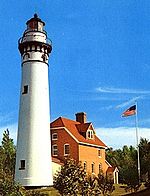
44°03′44.5″N 88°30′52.7″W / 44.062361°N 88.514639°W / 44.062361; -88.514639The Asylum Light is located just north of Oshkosh, Wisconsin, in Winnebago County, Wisconsin. The lighthouse is located on a small island just a few feet away from the mainland in Asylum Bay on Lake Winnebago, Wisconsin. This lighthouse marks the separation between North and South Asylum Bays.
History
In 1871, construction began on the Northern Asylum for the Insane which was later called the Winnebago Mental Health Institute. The former name stuck though hence the name of the point, and bay.[1] The lighthouse wasn't built until 1937 as the result of a "Works Progress Administration project". The Department of Transportation soon rejected the lighthouse as a navigational light causing it never to be lit.[1][2]
The lighthouse received $4,000 in structural repairs which were carried out in 2007.[1] In the mid 1990s a bridge was rebuilt to the island which allowed access to the Island that the lighthouse is on. Since that time though it has deteriorated rendering the structure unsafe for crossing.[2]
Notes
- ^ a b c "Asylum Point, WI". Lighthouse Friends. Retrieved September 29, 2017.
- ^ a b Nate Beck (February 25, 2017). "Asylum Point Lighthouse bridge beyond repair". www.thenorthwestern.com. Retrieved September 29, 2017.
Further reading
- Havighurst, Walter (1943) The Long Ships Passing: The Story of the Great Lakes, Macmillan Publishers.
- Oleszewski, Wes, Great Lakes Lighthouses, American and Canadian: A Comprehensive Directory/Guide to Great Lakes Lighthouses, (Gwinn, Michigan: Avery Color Studios, Inc., 1998) ISBN 0-932212-98-0.
- Pepper, Terry. "Seeing the Light: Lighthouses on the western Great Lakes". Archived from the original on January 30, 2008.
- Wright, Larry and Wright, Patricia, Great Lakes Lighthouses Encyclopedia Hardback (Erin: Boston Mills Press, 2006) ISBN 1-55046-399-3.
External links
- Rowlett, Russ. "Lighthouses of the United States: Eastern Wisconsin". The Lighthouse Directory. University of North Carolina at Chapel Hill.
- "Historic Light Station Information and Photography: Wisconsin". United States Coast Guard Historian's Office. Archived from the original on 2017-05-01.
- v
- t
- e
Lighthouses of Wisconsin
- Ashland Harbor Breakwater
- Chequamegon Point
- Devils Island
- Gull Island
- La Pointe
- Michigan Island
- Outer Island
- Raspberry Island
- Sand Island
- Wisconsin Point
- Algoma
- Baileys Harbor
- Baileys Harbor Range
- Cana Island
- Chambers Island
- Dunlap Reef Range
- Eagle Bluff
- Grassy Island Range
- Green Bay Harbor Entrance
- Green island
- Kenosha
- Kenosha North Pier
- Kevich
- Kewaunee Pierhead
- Long Tail
- Manitowoc Breakwater
- Milwaukee Breakwater
- Milwaukee Pierhead
- North Point
- Peshtigo Reef
- Pilot Island
- Plum Island Range
- Port Washington
- Port Washington Breakwater
- Pottawatomie
- Racine Harbor
- Racine North Breakwater
- Racine Reef
- Rawley Point
- Sheboygan
- Sherwood Point
- Sturgeon Bay Canal
- Sturgeon Bay Canal North Pierhead
- Two Rivers
- Wind Point
- Asylum
- Calumet
- Fond du Lac
- Neenah
- Rockwell
- Dunlap Reef Range Front
- Manitowoc Main
- Manitowoc North Pierhead
- Plum Island Range Front
- Racine North Pierhead
| Authority control databases: Geographic |
|
|---|


