Bennington Battle Monument
United States historic place
Bennington Battle Monument | |
U.S. Historic district Contributing property | |
 Aerial view of Bennington Battle Monument | |
| Location | Monument Circle Bennington, Vermont |
|---|---|
| Coordinates | 42°53′21″N 73°12′56″W / 42.88916°N 73.21563°W / 42.88916; -73.21563 |
| Part of | Old Bennington Historic District (ID84000030) |
| NRHP reference No. | 71000054 |
| Significant dates | |
| Added to NRHP | March 31, 1971 |
| Designated CP | October 4, 1984 |
The Bennington Battle Monument is a 306-foot-high (93 m)[1] stone obelisk located at 15 Monument Circle, in Bennington, Vermont, United States. The monument commemorates the Battle of Bennington during the American Revolutionary War.
In that battle, on 16 August 1777,[2] Brigadier General John Stark and 1,400 New Hampshire men, aided by Colonels Warner and Herrick of Vermont, Simonds of Massachusetts, and Moses Nichols of New Hampshire, defeated two detachments of General John Burgoyne's British army, who were seeking to capture a store of weapons and food maintained where the monument now stands. While the battle is termed the Battle of Bennington, it actually occurred about 10 miles (16 km) away, in Walloomsac, New York; the Bennington Battlefield, a U.S. National Historic Landmark, is entirely within the state of New York.
In 1877, a local historical society began to plan a monument for the battle's centenary, and considered many designs. One which called for a slender stone column only 100 feet (30 m) tall was showcased during the battle's centennial celebration, which was attended by President Rutherford B. Hayes. The committee eventually accepted J. Phillip Rinn's design with some changes. The monument's cornerstone was laid in 1887, and it was completed in November 1889 at a total cost of $112,000 (including the site). It is constructed of Sandy Hill Dolomite from present day Hudson Falls, New York, a blue-gray magnesian limestone containing numerous fossils. Dedication ceremonies were delayed until 1891, when President Benjamin Harrison attended the ceremonies and held a reception at the nearby Walloomsac Inn.[3] Today the Bennington Battle Monument is a Vermont State Historic Site.[4]
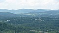
From its observatory level at 200 feet (61 m), which can be reached by elevator (but not the 417 stairs, which are closed), one can see Vermont along with the other U.S. states of Massachusetts and New York. A kettle captured from General Burgoyne's camp at Saratoga is visible in the monument along with a diorama of the second engagement, and information on how the monument was built. Statues of John Stark ("Live free or die"), Seth Warner, and other notables ornament the grounds.
The monument, while 10 miles (16 km) from the relevant battlefield, is located very close to what was once the site of the Catamount Tavern, where Ethan Allen and the Green Mountain Boys planned the capture of Fort Ticonderoga in 1775.
-
 Full view in late afternoon
 -
 View from elevator floor facing east towards Green Mountains
 -
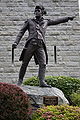 Statue of Brigadier General John Stark
 -
 Statue of Seth Warner


See also
- Bennington Battlefield
- Fort Rosecrans National Cemetery
- National Register of Historic Places listings in Bennington County, Vermont
- Saratoga Battle Monument
- USS Bennington Monument
References
- ^ "Bennington Battle Monument". benningtonbattlemonument.com. Retrieved August 21, 2019.
- ^ "Bennington Monument opens May 1". benningtonbanner.com. The Bennington Banner. Retrieved August 21, 2019.
- ^ "BENNINGTON BATTLE MONUMENT CELEBRATES 125TH". vermont.gov. State of Vermont. Retrieved August 21, 2019.
- ^ "Bennington Battle Monument". historicsites.vermont.gov. State of Vermont. Retrieved August 21, 2019.
External links
Wikimedia Commons has media related to Bennington Battle Monument.
- Vermont Historic Sites: Bennington Battle Monument
- Bennington.com: The Bennington Monument
- v
- t
- e
- Arlington Village Historic District
- Bennington College Historic District
- Bennington Fish Hatchery
- Carrigan Lane Historic District
- Center Shaftsbury Historic District
- Dorset Village Historic District
- Downtown Bennington Historic District
- East Arlington Village Historic District
- Equinox House Historic District
- Furnace Grove Historic District
- Holden–Leonard Workers Housing Historic District
- Kent Neighborhood Historic District
- Manchester Village Historic District
- North Bennington Historic District
- Old Bennington Historic District
- The Orchards
- Rupert Village Historic District

- Bennington High School
- Bennington Post Office
- Bennington Railroad Station
- W. H. Bradford Hook and Ladder Fire House
- William C. Bull House
- E. J. Bullock Block
- First Congregational Church of Bennington
- Robert Frost Farm
- Gov. Jonas Galusha Homestead
- Zera Hard House
- William Henry House
- Hildene
- Holden–Leonard Mill Complex
- Jenks Tavern
- Amos Lawrence House
- Manley-Lefevre House
- David Mathews House ‡
- Munro-Hawkins House
- North Bennington Depot
- Julius and Sophia Norton House
- Park-McCullough House
- Pratt-McDaniels-LaFlamme House
- Ritchie Block
- School Street Duplexes
- Frederick Squire House
- Tudor House
- Wait Block
- H.C. White Company Mill Complex
- Cora B. Whitney School
- Wilson House
- Yester House
- Arlington Green Covered Bridge
- Bennington Battle Monument
- Bennington Falls Covered Bridge
- Henry Covered Bridge
- Silk Covered Bridge
‡ This historic property also has portions in an adjacent state.


