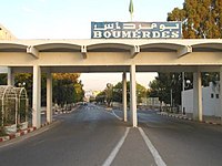
Boumerdès
City in Boumerdès Province, Algeria
Boumerdes بومرداس Bumerdas | |
|---|---|
City | |
 | |
 | |
| 36°45′37.23″N 3°28′20.52″E / 36.7603417°N 3.4723667°E / 36.7603417; 3.4723667 | |
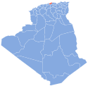
| Country | Algeria |
| Province | Boumerdès Province |
| District | Boumerdes District |
| Elevation | 50 m (160 ft) |
| Population (2008) | |
| • Total | 41 685 |
| Time zone | UTC+1 (CET) |
| Climate | Csa |
Boumerdès (Arabic: بومرداس; Kabyle: Bumerdas; formerly Rocher Noir) is the capital city of Boumerdès Province, Algeria. It is located on the Mediterranean Sea. It had a population of 15,000 in 1987 and 28,500 in 1998.[1]
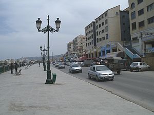
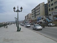
Boumerdès is a seaside city located in the north of Algeria about 50 km east of Algiers and 50 km west of Tizi Ouzou. During French occupation of Algeria, the city was named Rocher Noir, translated from French as Black Rock. The city became the capital of the province, having the same name, according to the administrative division in 1984.
It is the capital city of wilaya (province) of Boumerdès. The city is famous as a scientific center, including a number of national institutes and the University of M'hamed Bouguerra. The institutes include l'Institut Algérien du Pétrole (the Algerian Petroleum Institute IAP), Faculté des Hydrocarbures et de la Chimie (Faculty of Hydrocarbons and Chemistry FHC), l'Institut National d'Électricité et d'Électronique (The National Institute for Electricity and Electronics INELEC), l'Institut National de Génie mécanique (The National Institute of Mechanical Engineering ENGM), l'Institut National des Industries légères (The National Institute for Light Industries INIL).
The city is also known as an industrial center containing the headquarters of Sonatrach Exploration, l'Entreprise Nationale de Géophysique (ENAGEO), and le Centre de Recherches et de Développement (Research and Development Center for Sonatrach CRD).
In 2003, a devastating 6.8 magnitude earthquake shook northern Algeria with a maximum Mercalli intensity of X (Extreme).[2] The city was one of the most heavily hit places.[3] In total, more than 2,200 people were killed, over 10,000 were injured, and a moderate tsunami damaged boats at the Balearic Islands.[4]
Climate
Climate data for Boumerdés | |||||||||||||
|---|---|---|---|---|---|---|---|---|---|---|---|---|---|
| Month | Jan | Feb | Mar | Apr | May | Jun | Jul | Aug | Sep | Oct | Nov | Dec | Year |
| Mean daily maximum °C (°F) | 14.5 (58.1) | 14.8 (58.6) | 17.6 (63.7) | 20.2 (68.4) | 23.7 (74.7) | 28.8 (83.8) | 32.6 (90.7) | 32.8 (91.0) | 29.0 (84.2) | 25.5 (77.9) | 18.8 (65.8) | 15.5 (59.9) | 22.8 (73.1) |
| Daily mean °C (°F) | 9.8 (49.6) | 10.0 (50.0) | 12.5 (54.5) | 15.0 (59.0) | 18.4 (65.1) | 22.9 (73.2) | 26.4 (79.5) | 26.6 (79.9) | 23.3 (73.9) | 19.9 (67.8) | 14.1 (57.4) | 11.0 (51.8) | 17.5 (63.5) |
| Mean daily minimum °C (°F) | 5.9 (42.6) | 5.8 (42.4) | 7.8 (46.0) | 9.9 (49.8) | 12.9 (55.2) | 16.8 (62.2) | 20.0 (68.0) | 20.8 (69.4) | 18.3 (64.9) | 15.2 (59.4) | 10.4 (50.7) | 7.3 (45.1) | 12.6 (54.6) |
| Average precipitation mm (inches) | 94 (3.7) | 79 (3.1) | 74 (2.9) | 69 (2.7) | 53 (2.1) | 9 (0.4) | 2 (0.1) | 9 (0.4) | 34 (1.3) | 61 (2.4) | 96 (3.8) | 92 (3.6) | 672 (26.5) |
| Average precipitation days | 9 | 8 | 7 | 7 | 5 | 2 | 1 | 1 | 5 | 6 | 9 | 8 | 68 |
| Average relative humidity (%) | 75 | 73 | 72 | 71 | 69 | 59 | 54 | 56 | 63 | 64 | 71 | 74 | 67 |
| Source: Climate data.org(1991-2021)[5] | |||||||||||||
Neighbourhoods
The neighbourhoods of Boumerdès are:
-
-
 Cité 11 décembre 1960
 -
 Quartier du front de mer
 -
 Cité Ibn Khaldoun
 -
 Cité du Rocher Noir


Rivers

This commune is crossed by several rivers:
- Meraldene River
- Beni Arab River [Wikidata]
- Boumerdès River [Wikidata]
- Corso River [Wikidata]
- El Karma River [Wikidata]
- Sidi Ali River [Wikidata]
- Tatarig River [Wikidata]
Geology
Several mountain peaks are found in this commune:
- Bouarous Mount [Wikidata] (444 m)
- Cap Blanc Mount [Wikidata] (420 m)
History
- First Battle of the Issers (1837)
Health

Sport
| Club | Division | Level | Location |
|---|---|---|---|
| JS Boumerdes | Inter-Régions Division | 3 | Boumerdès |
| RC Boumerdes | Régionale II | 5 | Boumerdès |
Notable people
- Brahim Boushaki, Algerian theologian
- Adel Djerrar, Algerian footballer
- Mohamed Flissi, Algerian boxer
- Ali Laskri, Algerian politician
- Hassiba Boumerdassi [Wikidata], Algerian lawyer
- Samia Boumerdassi [Wikidata], Algerian artist
- Selma Boumerdassi [Wikidata], Algerian academic
References
 Algeria portal

- ^ "populstat.info". Archived from the original on March 3, 2016.
- ^ National Geophysical Data Center / World Data Service (NGDC/WDS), Significant Earthquake Database (Data Set), National Geophysical Data Center, NOAA, doi:10.7289/V5TD9V7K
- ^ Oliveira, Carlos Sousa; Roca, Antoni; Xavier, Goula (2006), Assessing and Managing Earthquake Risk, Springer, p. 444, ISBN 978-1-4020-1827-5
- ^ Magnitude 6.8 Northern Algeria Archived 2008-05-11 at the Wayback Machine United States Geological Survey
- ^ "Boumerdés Climate: Temperature & Weather by month". Climate data. Archived from the original on 2024-05-21. Retrieved 2023-07-28.
External links
- "Website of all nowadays and ancient people from Boumerdès".
- "Website of all nowadays and ancient people from dzair".
- Falling Rain Genomics - elevation = 41m. "Geographical information on Boumerdas, Algeria". Retrieved 2008-04-27.
{{cite web}}: CS1 maint: numeric names: authors list (link)


| |
|---|---|
| A | |
| B | |
| C | |
| D | |
| E | |
| F | |
| G | |
| H | |
| L | |
| M | |
| O | |
| S | |
| T | |
| Z | |
| Authority control databases: National |
|
|---|
Wikimedia Commons has media related to Boumerdès.
 | This article about a location in Boumerdès Province is a stub. You can help Wikipedia by expanding it. |
- v
- t
- e


