Bourem
Commune and town in Gao Region, Mali
16°57′12″N 0°21′14″W / 16.95333°N 0.35389°W / 16.95333; -0.35389 Mali
Mali[1]
(2009 census)[2]
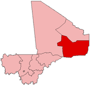
Bourem is a commune and small town in the Gao Region of northeastern Mali. The town sits on the left bank of the River Niger.
It was the site of an attack by the Permanent Strategic Framework for Peace, Security, and Development (CSP-PSD) on the Malian Armed Forces and their Wagner Group allies on 12 September 2023.
References
- ^ Schéma Directeur de Lutte Contre l’Ensablement dans le Nord du Mali (6ème et 7ème Régions): Monographie de la Commune de Bourem (PDF) (in French), Ministère de l’Environnement et de l’Assainissement, République du Mali, 2004, archived from the original (PDF) on 2011-07-22.
- ^ Resultats Provisoires RGPH 2009 (Région de Gao) (PDF) (in French), République de Mali: Institut National de la Statistique, archived from the original (PDF) on 2011-07-22.
External links
- Plan de Sécurite Alimentaire Commune Urbaine de Bourem 2005-2009 (PDF) (in French), Commissariat à la Sécurité Alimentaire, République du Mali, USAID-Mali, 2005, archived from the original (PDF) on 2014-05-19, retrieved 2011-02-12.
 | This Gao Region location article is a stub. You can help Wikipedia by expanding it. |
- v
- t
- e


