Bradley State Scenic Viewpoint
State park in Oregon
46°10′15″N 123°26′12″W / 46.1709436°N 123.4367955°W / 46.1709436; -123.4367955[1]
Bradley State Scenic Viewpoint is a state park in the U.S. state of Oregon, administered by the Oregon Parks and Recreation Department. It is located directly north of U.S. Route 30 between Astoria and Portland.[2][3]
History
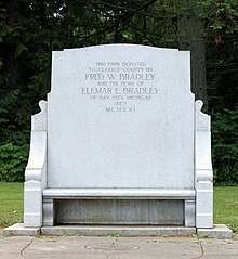
The land that now makes up Bradley State Scenic Viewpoint was donated to Clatsop County in 1921 by Fred W. Bradley and the other heirs of the estate of Elmar E. Bradley. The Bradley family owned most of the land in the area at the time. In March of the next year, the Oregon Highway Division (now Oregon Department of Transportation) took control of the site, although the deed was not officially signed until 1932.[4][5]
The site was soon developed into a rest area, and was originally known as Bradley Wayside.[4] Parking areas, picnic benches, and restrooms were added as well as a water system using a source approximately two miles west. The highway at the time went directly through the park, but was reconstructed in the 1960s and bypassed the park to the south.[5][6][7] Entrance to the park is now via an entry road.[8]
A concessionaire operated the park in its early years, and the contract was extended multiple times, before eventually being cancelled due to neither the state nor the concessionaire being fully satisfied.[5]
Amenities
The park is for day-use only. It features flush restrooms, a drinking fountain, multiple picnic tables, and a memorial bench. Grassy areas also allow room for pets and games.

See also
References
- ^ "Bradley State Park". Geographic Names Information System. United States Geological Survey, United States Department of the Interior. Retrieved June 21, 2011.
- ^ "Bradley State Scenic Viewpoint - Oregon State Parks". stateparks.oregon.gov. Retrieved July 14, 2024.
- ^ "Bradley State Scenic Viewpoint". Travel Oregon.
- ^ a b "History of the Oregon State Parks — 1917-1963 (Section 5: State Parks and Waysides)". npshistory.com. Retrieved July 14, 2024.
- ^ a b c "Recreating the Columbia River Highway - Route 2: Clatsop Crest / Bradley State Scenic Viewpoint". sites.google.com. Retrieved July 14, 2024.
- ^ "Highway 30 Plan Gains Approval". The Oregonian. February 23, 1957. p. 6.
- ^ "Prospects Slim For Listing Highway 30 As Interstate". Longview Daily News. May 25, 1967. p. 5. Archived from the original on December 2, 2022. Retrieved December 1, 2022 – via Newspapers.com.
- ^ "Bradley State Scenic Viewpoint · 46975 US-30, Clatskanie, OR 97016". Bradley State Scenic Viewpoint · 46975 US-30, Clatskanie, OR 97016. Retrieved July 14, 2024.
External links
![]() Media related to Bradley State Scenic Viewpoint at Wikimedia Commons
Media related to Bradley State Scenic Viewpoint at Wikimedia Commons
- "Bradley State Scenic Viewpoint". Oregon Parks and Recreation Department. Retrieved June 21, 2011.
- v
- t
- e
| Parks |
| ||||||||||||||||||
|---|---|---|---|---|---|---|---|---|---|---|---|---|---|---|---|---|---|---|---|
| Forests | |||||||||||||||||||
| Wildlife areas |
|
| Metro |
|
|---|---|
| Tualatin Hills Park and Recreation District |
 Category
- Oregon Parks and Recreation Department
- Portland
 Commons

 | This Clatsop County, Oregon state location article is a stub. You can help Wikipedia by expanding it. |
- v
- t
- e


