Calceta
Town in Manabí, Ecuador

Flag
Seal
Calceta, ls sin par (Calceta, the peerless)
(2022 census)[1]
Calceta is a town in the Manabí province of Ecuador. Situated on the banks of the Carrizal river, and surrounded by a valley of the same name, Calceta is a center of trade and services for the north-central zone of Manabí. It has a dozen high schools and more than twenty schools. 3 kilometres away is the Escuela Superior Politécnica de Manabí (ESPAM), a modern agricultural and environmental university.
Attractions
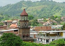
The tower of the Juan Manuel Alava public clock, The Saint Agustín Church, the Civic Square, and the San Bartolo old red bridge, assembled in 1910.
yun lugar muy atractivo
Climate
| Climate data for Calceta, elevation 58 m (190 ft), (1961–1990) | |||||||||||||
|---|---|---|---|---|---|---|---|---|---|---|---|---|---|
| Month | Jan | Feb | Mar | Apr | May | Jun | Jul | Aug | Sep | Oct | Nov | Dec | Year |
| Mean daily maximum °C (°F) | 31.5 (88.7) | 31.6 (88.9) | 32.0 (89.6) | 32.2 (90.0) | 31.0 (87.8) | 29.7 (85.5) | 29.8 (85.6) | 30.7 (87.3) | 31.3 (88.3) | 31.2 (88.2) | 31.1 (88.0) | 31.6 (88.9) | 31.1 (88.1) |
| Daily mean °C (°F) | 26.2 (79.2) | 26.2 (79.2) | 26.7 (80.1) | 26.7 (80.1) | 26.2 (79.2) | 25.2 (77.4) | 24.8 (76.6) | 24.8 (76.6) | 25.1 (77.2) | 25.2 (77.4) | 25.3 (77.5) | 26.0 (78.8) | 25.7 (78.3) |
| Mean daily minimum °C (°F) | 21.7 (71.1) | 21.8 (71.2) | 22.2 (72.0) | 22.0 (71.6) | 21.7 (71.1) | 20.7 (69.3) | 20.2 (68.4) | 19.8 (67.6) | 20.2 (68.4) | 20.6 (69.1) | 20.2 (68.4) | 20.7 (69.3) | 21.0 (69.8) |
| Average precipitation mm (inches) | 190.0 (7.48) | 211.0 (8.31) | 268.0 (10.55) | 148.0 (5.83) | 46.0 (1.81) | 34.0 (1.34) | 12.0 (0.47) | 5.0 (0.20) | 8.0 (0.31) | 6.0 (0.24) | 6.0 (0.24) | 27.0 (1.06) | 961 (37.84) |
| Source: FAO[2] | |||||||||||||
References
Sources
- World-Gazetteer.com
Authority control databases | |
|---|---|
| International |
|
| National |
|
| Other |
|
- v
- t
- e


