California Historical Landmarks in Sonoma County
This is a list of the properties and districts — listed as California Historical Landmarks — within Sonoma County, California.
- Note: Click the "Map of all coordinates" link to the right to view a Google map of all properties and districts with latitude and longitude coordinates in the table below.
Listings
| Image | [1] | Landmark name | Location | City or town | Summary |
|---|---|---|---|---|---|
 | 7 | Bear Flag Monument | Sonoma Plaza 38°17′36″N 122°27′24″W / 38.293233°N 122.4568°W / 38.293233; -122.4568 (Bear Flag Monument) | Sonoma | |
 | 17 | Blue Wing Inn | Sonoma State Historic Park 38°17′36″N 122°27′20″W / 38.29345°N 122.455483°W / 38.29345; -122.455483 (Blue Wing Inn) | Sonoma | |
 | 833 | Bodega Bay & Harbor | Doran Park 38°19′25″N 123°02′52″W / 38.323611°N 123.047778°W / 38.323611; -123.047778 (Bodega Bay & Harbor) | Bodega Bay | |
 | 392 | Buena Vista Winery | 18000 Old Winery Rd. 38°17′58″N 122°25′23″W / 38.299444°N 122.423056°W / 38.299444; -122.423056 (Buena Vista Winery) | Sonoma | Also on the NRHP list as NPS-86001902 |
 | 835 | Cooper's Sawmill | Mirabel and River Rds. 38°29′36″N 122°53′45″W / 38.4934694444444°N 122.895827777778°W / 38.4934694444444; -122.895827777778 (Cooper's Sawmill) | Santa Rosa | |
 | 879 | Cotati Downtown Plaza | Downtown plaza 38°19′36″N 122°42′22″W / 38.32655°N 122.706167°W / 38.32655; -122.706167 (Cotati Downtown Plaza) | Cotati | |
 | 5 | Fort Ross | Fort Ross State Historic Park, 19005 Coast Hwy 38°30′51″N 123°14′34″W / 38.514289°N 123.242708°W / 38.514289; -123.242708 (Fort Ross) | Jenner | |
 | 392-1 | Haraszthy Villa | Castle Rd. near Buena Vista Winery 38°18′02″N 122°25′32″W / 38.30047°N 122.425576°W / 38.30047; -122.425576 (Haraszthy Villa) | Sonoma | |
 | 981 | Icaria-Speranza Commune | W side of Asti Rd. 38°46′27″N 122°59′59″W / 38.7742611111111°N 122.999755555556°W / 38.7742611111111; -122.999755555556 (Icaria-Speranza Commune) | Cloverdale | |
 | 621 | Italian Swiss Colony | 38°45′46″N 122°58′26″W / 38.7628388888889°N 122.973961111111°W / 38.7628388888889; -122.973961111111 (Italian Swiss Colony) | Asti | |
 | 743 | Jack London State Historic Park | Jack London State Historic Park 38°21′02″N 122°32′35″W / 38.350556°N 122.543056°W / 38.350556; -122.543056 (Jack London State Historic Park) | Glen Ellen | Also on the NRHP list as NPS-66000240 |
 Upload Photo | 939 | John Medica Gardens | 5000 Medica Rd. 35°34′04″N 121°05′51″W / 35.5677805555556°N 121.097405555556°W / 35.5677805555556; -121.097405555556 (John Medica Gardens) | Santa Rosa | Twentieth Century Folk Art |
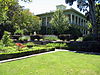
 | 234 | Luther Burbank Home and Gardens | 200 Santa Rosa Ave. 38°26′10″N 122°42′42″W / 38.436111°N 122.711667°W / 38.436111; -122.711667 (Luther Burbank Home and Gardens) | Santa Rosa | Also on the NRHP list as NPS-66000241 |
 | 3 | Mission San Francisco de Solano | Sonoma State Historic Park 38°17′38″N 122°27′21″W / 38.294012°N 122.455781°W / 38.294012; -122.455781 (Mission San Francisco de Solano) | Sonoma | |
 | 667 | Nash-Patton Adobe | 579 1st St. E. 38°17′25″N 122°27′25″W / 38.290367°N 122.45695°W / 38.290367; -122.45695 (Nash-Patton Adobe) | Sonoma | |
 | 915 | Petrified Forest | 4100 Petrified Forest Rd. 38°33′20″N 122°38′20″W / 38.555499°N 122.638943°W / 38.555499; -122.638943 (Petrified Forest) | Calistoga | |
 | 316 | Presidio of Sonoma | Sonoma State Historic Park 38°17′37″N 122°27′24″W / 38.2937°N 122.4566°W / 38.2937; -122.4566 (Presidio of Sonoma) | Sonoma | |
 | 18 | Rancho Petaluma Adobe | Petaluma Adobe State Historic Park, 3325 Adobe Rd. 38°15′20″N 122°35′04″W / 38.25547°N 122.58451°W / 38.25547; -122.58451 (Rancho Petaluma Adobe) | Petaluma | Also on the NRHP list as NPS-70000151 |
 | 820 | Saint Teresa of Avila Church, Bodega | Bodega Hwy near Bodega Ln. 38°20′46″N 122°58′21″W / 38.346197°N 122.972528°W / 38.346197; -122.972528 (Saint Teresa of Avila Church, Bodega) | Bodega | |
 | 501 | Salvador Vallejo Adobe | 421 1st St. 38°17′37″N 122°27′32″W / 38.2936°N 122.458783°W / 38.2936; -122.458783 (Salvador Vallejo Adobe) | Sonoma | Built in 1846 home of Captain Salvador Vallejo[2] |
 | 739 | Sebastiani Vineyards and Winery | 394 4th St E 38°17′36″N 122°26′58″W / 38.293367°N 122.449483°W / 38.293367; -122.449483 (Sebastiani Vineyards and Winery) | Sonoma | |
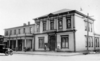
 | 496 | Swiss Hotel | 18 W. Spain St. 38°17′38″N 122°27′29″W / 38.2938°N 122.457967°W / 38.2938; -122.457967 (Swiss Hotel) | Sonoma | |
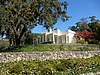
 | 237 | Temelec Hall | 220 Temelec Circle 38°16′00″N 122°29′34″W / 38.266667°N 122.492778°W / 38.266667; -122.492778 (Temelec Hall) | Temelec | |
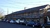
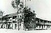
 | 627 | Union Hotel & Union Hall | 35 Napa and 1st St. 38°17′31″N 122°27′31″W / 38.2918555555556°N 122.458747222222°W / 38.2918555555556; -122.458747222222 (Union Hotel & Union Hall) | Sonoma | |
 | 4 | Vallejo Estate | Corner of Spain and West 3rd Streets 38°17′50″N 122°27′40″W / 38.297222°N 122.461111°W / 38.297222; -122.461111 (Vallejo Estate) | Sonoma | Also on the NRHP list as NPS-72000262 |
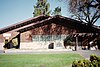
 | 893 | Walters Ranch Hop Kiln | 7501 Sonoma Hwy. 38°32′10″N 122°52′04″W / 38.536134°N 122.867848°W / 38.536134; -122.867848 (Walters Ranch Hop Kiln) | Healdsburg | |
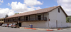
 | 692 | William Hood House | 7501 Sonoma Hwy. 38°26′37″N 122°34′36″W / 38.443611°N 122.576667°W / 38.443611; -122.576667 (William Hood House) | Santa Rosa | Also on the NRHP list as NPS-97001658 |
See also
- List of California Historical Landmarks
- National Register of Historic Places listings in Sonoma County, California
References
Wikimedia Commons has media related to California Historical Landmarks in Sonoma County, California.
Map all coordinates using OpenStreetMap
Download coordinates as:
- KML
- GPX (all coordinates)
- GPX (primary coordinates)
- GPX (secondary coordinates)
- v
- t
- e
| |||||||||||||||||
National Forests and Grasslands | |||||||
|---|---|---|---|---|---|---|---|
| |||||||
|
| |||||||
| |||||||
|
|
- Heritage registers
- National Natural Landmarks


