Chevelon Creek
Stream in Navajo County, Arizona
| Chevelon Creek | |
|---|---|
 | |
| Location | |
| Country | United States |
| State | Arizona |
| Physical characteristics | |
| Source | |
| • elevation | 7,000 ft (2,100 m) |
| Mouth | |
• elevation | 6,400 ft (2,000 m) |
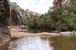
34°25′57″N 110°50′36″W / 34.43250°N 110.84333°W / 34.43250; -110.84333 Chevelon Creek is located in the Mogollon Rim area of the state of Arizona. The closest town Heber is 18 miles (29 km) away. The facilities are maintained by Apache–Sitgreaves National Forest division of the USDA Forest Service.
Crossings
There is a bridge at Mormon Crossing, named after the Mormon settlers who abandoned an attempt to start a community there through lack of water.[1]
Fish species
- Rainbow trout
- Brown trout
References
- ^ Granger, Byrd H. (1957). "Early Mormon Place Names in Arizona". Western Folklore. 16 (1): 43–47. doi:10.2307/1497061. ISSN 0043-373X. JSTOR 1497061.

External links
- Arizona Fishing Locations Map
- Arizona Boating Locations Facilities Map
- v
- t
- e
Rivers and streams of Arizona
- Agua Sal Creek
- Black Creek
- Black River
- Blue River
- Chinle Creek
- Chinle Wash
- Kinlichee Creek
- Laguña Creek
- Little Colorado River
- Puerco River
- San Francisco River
- Walker Creek
- Zuni River
- Babocomari River
- Black Draw
- Bonita Creek
- Dragoon Wash
- Mescal Arroyo
- San Bernardino River
- San Pedro River
- San Simon River
- Steins Creek
- Tres Alamos Wash
- Whitewater Draw
- Canyon Creek
- Canyon Creek
- Cherry Creek
- Christopher Creek
- East Verde River
- Fossil Creek
- Gila River
- Haigler Creek
- Horton Creek
- Negro Wash
- Salome Creek
- Salt River
- Tonto Creek
- White River
- Workman Creek
- Aravaipa Creek
- Ash Creek
- Black River
- Gila River
- San Pedro River
- San Simon River
- Black River
- Blue River
- Eagle Creek
- San Francisco River
- Bouse Wash
- Colorado River
- Santa Maria River
- Tyson Wash
- Agua Fria River
- Centennial Wash
- Gila River
- Hassayampa River
- Salt River
- Verde River
- Beaver Dam Wash
- Big Sandy River
- Bill Williams River
- Centennial Wash
- Colorado River
- Diamond Creek
- Kingman Wash
- Sacramento Wash
- Santa Maria River
- Virgin River
- Black River
- Chevelon Creek
- Cibecue Creek
- Clear Creek
- Laguña Creek
- Little Colorado River
- Little Lithodendron Wash
- Puerco River
- Silver Creek
- White River
- Arivaca Creek
- Brawley Wash
- Ciénega Creek
- Mescal Arroyo
- Molino Creek
- Rillito River
- Sabino Creek
- San Cristobal Wash
- San Pedro River
- Santa Cruz River
- Tenmile Wash
- Gila River
- San Pedro River
- Santa Cruz River
- Tom Mix Wash
- Babocomari River
- Ciénega Creek
- Harshaw Creek
- Santa Cruz River
- Sonoita Creek
- Agua Fria River
- Fossil Creek
- Granite Creek
- Hassayampa River
- Verde River
| Authority control databases: National |
|
|---|


