Christophe Colomb Avenue
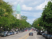 Christophe Colomb Avenue, seen northbound, with the tower of Église St-Arsène. | |
| Native name | avenue Christophe-Colomb (French) |
|---|---|
| Namesake | Christopher Colombus |
| Length | 8.5 km (5.3 mi) |
| Location | Montreal |
| South end | Rachel Street |
| Major junctions |  |
| North end | Gouin Boulevard |
| Construction | |
| Inauguration | 1897 |
Christophe Colomb Avenue (officially in French: avenue Christophe-Colomb) is a major north–south street in Montreal, Quebec, Canada. It has a length of 8.5 kilometres (5.3 miles), and crosses the boroughs of Le Plateau-Mont-Royal, Rosemont-La Petite-Patrie, Villeray-Saint-Michel-Parc-Extension and Ahuntsic-Cartierville. The street is predominantly residential south of Villeray Street and is a large urban boulevard to the north. It is served primarily by the weekday only 13 Christophe Colomb route.
The street was named after Christopher Columbus on December 20, 1897.
Christophe Colomb Avenue begins at Rachel Street, near Lafontaine Park in the south. It is an extension of Parc Lafontaine Street. It is interrupted by Sir Wilfrid Laurier Park between Laurier Avenue and Saint Grégoire Street for distance of 400 metres. In the north, the street ends at Gouin Boulevard, near Louis Hébert Park and the Rivière des Prairies.
Points of interest
- La Fontaine Park
- Sir Wilfrid Laurier Park
- Église Saint-Arsène
- Patro Le Prevost, sports and recreation centre
- Villeray Park
- Complexe sportif Claude-Robillard
- Boisé de Saint-Sulpice
- v
- t
- e
- Boulevard Saint-Charles
- Boulevard Saint-Jean
- Boulevard Des Sources
- Laurentian Boulevard
- Décarie Boulevard
- Greene Avenue
- Atwater Avenue
- Côte-des-Neiges Road
- Guy Street
- Mackay Street
- Bishop Street
- Crescent Street
- Mountain Street
- Drummond Street
- Stanley Street
- Peel Street
- Metcalfe Street
- McTavish Street
- Mansfield Street
- McGill College Avenue
- Robert-Bourassa Boulevard / University Street
- McGill Street
- Park Avenue
- Jeanne-Mance Street
- Saint Urbain Street
- Saint Laurent Boulevard
- Saint Denis Street
- Berri Street
- Saint Hubert Street
- Christophe Colomb Avenue
- Papineau Avenue
- De Lorimier Avenue
- D'Iberville Street
- Saint-Michel Boulevard
- Pie-IX Boulevard
- Lacordaire Boulevard
- De L'Assomption Boulevard
- Langelier Boulevard
- Rue de la Commune
- Wellington Street
- Saint Patrick Street
- Saint-Paul Street
- Notre-Dame Street
- Saint Jacques Street
- Saint Antoine Street
- De la Gauchetière Street
- René Lévesque Boulevard
- Saint Catherine Street
- De Maisonneuve Boulevard
- Ontario Street
- Sherbrooke Street
- Doctor Penfield Avenue
- Pine Avenue
- Mount Royal Avenue
- Saint Joseph Boulevard
- Laurier Avenue
- Côte-Saint-Luc Road
- Queen Mary Road
- Côte-Sainte-Catherine Road
- Beaubien Street
- Van Horne Avenue
- Jean Talon Street
- Jarry Street
- Côte-Vertu Boulevard
- Henri Bourassa Boulevard
- Pierrefonds Boulevard
- Gouin Boulevard
- LaSalle Boulevard
 Category
 WikiProject

45°32′43″N 73°36′58″W / 45.5453°N 73.616°W / 45.5453; -73.616
 | This Montreal-related article is a stub. You can help Wikipedia by expanding it. |
- v
- t
- e
 | This Quebec road, road transport or highway-related article is a stub. You can help Wikipedia by expanding it. |
- v
- t
- e


