Cliff Palace
Human settlement in Montezuma County, Colorado, United States of America
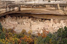
Cliff Palace is the largest cliff dwelling in North America. The structure built by the Ancestral Puebloans is located in Mesa Verde National Park in their former homeland region. The cliff dwelling and park are in Montezuma County, in the southwestern corner of Colorado, in the Southwestern United States.
History

Tree-ring dating indicates that construction and refurbishing of Cliff Palace was continuous approximately from 1190 CE through 1260 CE, although the major portion of the building was done within a 20-year time span. The Ancestral Puebloans who constructed this cliff dwelling and the others like it at Mesa Verde were driven to these defensible positions by "increasing competition amidst changing climatic conditions".[1] Cliff Palace was abandoned by 1300, though debate is ongoing as to the cause. Some contend that a series of megadroughts interrupting food production systems was the main cause.
Cliff Palace was rediscovered in 1888 by Richard Wetherill and Charlie Mason while they were looking for stray cattle.[2][3][4]
Description
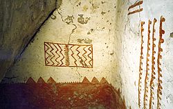
Cliff Palace was constructed primarily out of sandstone, mortar and wooden beams. The sandstone was shaped using harder stones, and a mortar of soil, water and ash was used to hold everything together. "Chinking" stones were placed within the mortar to fill gaps and provide stability. Many of the walls were decorated with colored earthen plasters, which were the first to erode over time. [5] Many visitors wonder about the relatively small size of the doorways at Cliff Palace; the explanation being that at the time the average man was under 5 feet 6 inches (1.68 m), while the average woman was closer to 5 feet (1.5 m)[4] Cliff Palace contains 23 kivas (round sunken rooms of ceremonial importance) and 150 rooms and had a population of approximately 100 people. One kiva, in the center of the ruin, is at a point where the entire structure is partitioned by a series of walls with no doorways or other access portals. The walls of this kiva were plastered with one color on one side and a different color on the opposing side.[4] "It is thought that Cliff Palace was a social, administrative site with high ceremonial usage."[4] Archaeologists believe that Cliff Palace contained more clans than the surrounding Mesa Verde communities. This belief stems from the higher ratio of rooms to kivas. Cliff Palace has a room-to-kiva ratio of 9 to 1. The average room-to-kiva ratio for a Mesa Verde community is 12 to 1.[1] This ratio of kivas to rooms may suggest that Cliff Palace might have been the center of a large polity that included surrounding small communities.[1]
A large square tower is to the right and almost reaches the cave "roof". It was in ruins by the 1800s. The National Park Service carefully restored it to its approximate height and stature, making it one of the most memorable buildings in Cliff Palace. It is the tallest structure at Mesa Verde standing at 26 feet (7.9 m) tall, with four levels. Slightly differently colored materials were used to show that it was a restoration.[6][7]
-
 A 13th-century mural of a rectangular tower believed to be Cliff Palace
 -
 The ground plan for Cliff Palace from a survey published in a book by Jesse Walter Fewkes, c. 1909
 -
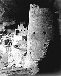 Round tower, Cliff Palace in 1941.
A 1941 photograph of Cliff Palace by Ansel Adams -
 The dwellings at Cliff Palace in September 2004
 -
 Cliff Palace in October 2018


References
- ^ a b c Snow, Dean R. (2010). Archaeology of Native North America. New York: Prentice-Hall. p. 128. ISBN 9780136156864.
- ^ Turney, Chris (2008). Ice, Mud & Blood: Lessons of Climates Past. Macmillan. ISBN 9780230553835.
- ^ "People". NPS.gov. National Park Service. Retrieved November 11, 2010.
- ^ a b c d "Cliff Palace". NPS.gov. National Park Service. Retrieved March 20, 2012.
- ^ https://www.nps.gov/teachers/classrooms/upload/Lesson-Plan-The-Dirt-on-Ancestral-Puebloan-Plaster.pdf [bare URL PDF]
- ^ "Preservation". NPS.gov. National Park Service. Retrieved November 11, 2010.
- ^ "Square Tower House Description". CyArk.org. Archived from the original on September 22, 2009. Retrieved March 20, 2012.
Bibliography
 North America portal

- Chapen, Frederick H. The Land of the Cliff-Dwellers. Appalachian Mountain Club, W. B. Clarke and Co., Boston, 1892. Reprinted by the University of Arizona Press, with notes and foreword by Robert H. Lister, 1988. ISBN 0-8165-1052-0.
- Noble, David Grant. "Ancient Ruins of the Southwest", pp. 36–43.Northland Publishing, Flagstaff, Arizona 1995. ISBN 0-87358-530-5.
- Oppelt, Norman T. "Guide to Prehistoric Ruins of the Southwest", pp. 159–161. Pruett Publishing, Boulder, Colorado, 1989. ISBN 0-87108-783-9.
External links
Wikimedia Commons has media related to Cliff Palace.
- Cliff Palace at National Park Service
- Mesa Verde National Park at National Park Service
- Map showing location of Cliff Palace at National Park Service
- v
- t
- e

- Periods
- Lithic
- Archaic
- Formative
- Classic
- Post-Classic
cultures
- Adena
- Alachua
- Ancient Beringian
- Ancestral Pueblo (Anasazi)
- Avonlea
- Baytown
- Belle Glade
- Buttermilk Creek complex
- Caborn-Welborn
- Cades Pond
- Calf Creek
- Caloosahatchee
- Clovis
- Coles Creek
- Comondú
- Deptford
- Folsom
- Fort Ancient
- Fort Walton
- Fremont
- Glacial Kame
- Glades
- Hohokam
- Hopewell
- La Jolla
- Las Palmas
- Maritime Archaic
- Mississippian
- Mogollon
- Monongahela
- Old Cordilleran
- Oneota
- Paleo-Arctic
- Paleo-Indians
- Patayan
- Plano
- Plaquemine
- Poverty Point
- Red Ocher
- Safety Harbor
- Santa Rosa-Swift Creek
- St. Johns
- Steed-Kisker
- Suwannee Valley
- Tchefuncte
- Troyville
- Weeden Island
sites
- Angel Mounds
- Anzick site
- Bandelier National Monument
- Bastian
- Benson
- Blue Spring Shelter
- Bluefish Caves
- The Bluff Point Stoneworks
- Brewster
- Cahokia
- Candelaria Cave
- Casa Grande
- Chaco Canyon
- Coso Rock Art District
- Crystal River
- Cuarenta Casas
- Cueva de la Olla
- Cutler
- Eaker
- El Fin del Mundo
- El Vallecito
- Effigy Mounds
- Etowah Indian Mounds
- Eva
- Folsom
- Fort Ancient
- Fort Center
- Fort Juelson
- Four Mounds
- Gila Cliff Dwellings
- Glenwood
- Grimes Point
- Helen Blazes
- Holly Bluff
- Hopewell Culture National Historical Park
- Horr's Island
- Huápoca
- Key Marco
- Kimball Village
- Kincaid Mounds
- Kolomoki Mounds
- Lake Jackson Mounds
- Lehner Mammoth-Kill Site
- L'Anse aux Meadows
- Lynch Quarry Site
- Marksville
- Marmes Rockshelter
- Meadowcroft Rockshelter
- Mesa Verde
- Moaning Cavern
- Moorehead Circle
- Morrison Mounds
- Moundville
- Mummy Cave
- Nodena site
- Ocmulgee Mounds
- Old Stone Fort
- Orwell site
- Paquime
- Painted Bluff
- Parkin Park
- Pinson Mounds
- Plum Bayou Mounds
- Portsmouth Earthworks
- Poverty Point
- Pueblo Bonito
- Rassawek
- Recapture Canyon
- River Styx
- Roberts Island
- Rock Eagle
- Rock Hawk
- Rosenstock Village
- Russell Cave
- Salmon Ruins
- Serpent Mound
- Sierra de San Francisco
- Shell ring sites
- Spiro Mounds
- Stallings Island
- SunWatch
- Taos Pueblo
- Town Creek Indian Mound
- Turkey River Mounds
- Upward Sun River
- Velda Mound
- West Oak Forest Earthlodge
- Wickiup Hill
- Windover
- Winterville
- Wupatki
remains
- Aridoamerica
- Ballgame
- Black drink
- Ceremonial pipe
- Chunkey
- Clovis point
- Container Revolution
- Eastern Agricultural Complex
- Eden point
- Effigy mound
- Falcon dancer
- Folsom point
- Green Corn Ceremony
- Horned Serpent
- Kiva
- Medicine wheel
- Metallurgy
- Mi'kmaq hieroglyphic writing
- Mound Builders
- N.A.G.P.R.A.
- Norse colonization of North America
- Oasisamerica
- Piasa
- Projectile point
- Southeastern Ceremonial Complex
- Stickball
- Three Sisters agriculture
- Thunderbird
- Transoceanic contact
- Underwater panther
- Water glyphs
- Related
- Genetic history
- Pre-Columbian era
37°10′00″N 108°28′22″W / 37.16667°N 108.47278°W / 37.16667; -108.47278


