Cooper County, New South Wales
Map all coordinates using OpenStreetMap
Download coordinates as:
- KML
- GPX (all coordinates)
- GPX (primary coordinates)
- GPX (secondary coordinates)
Cadastral in New South Wales, Australia
| Cooper New South Wales | |||||||||||||||
|---|---|---|---|---|---|---|---|---|---|---|---|---|---|---|---|
 Location in New South Wales | |||||||||||||||
| |||||||||||||||
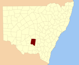
Cooper County is one of the 141 cadastral divisions of New South Wales. It contains the town of Barellan. The Murrumbidgee River is the southern boundary.
Cooper County was named in honour of the merchant and philanthropist Sir Daniel Cooper (1821-1902).[1]
Parishes within this county

A full list of parishes found within this county; their current LGA and mapping coordinates to the approximate centre of each location is as follows:
| Parish | LGA | Coordinates |
|---|---|---|
| Ariah | Bland Shire Council | 34°03′54″S 146°42′04″E / 34.06500°S 146.70111°E / -34.06500; 146.70111 (Ariah) |
| Barellan | Narrandera Shire Council | 34°13′54″S 146°29′04″E / 34.23167°S 146.48444°E / -34.23167; 146.48444 (Barellan) |
| Barralong | Narrandera Shire Council | 34°20′54″S 146°33′04″E / 34.34833°S 146.55111°E / -34.34833; 146.55111 (Barralong) |
| Beremabere | Narrandera Shire Council | 34°32′54″S 146°34′04″E / 34.54833°S 146.56778°E / -34.54833; 146.56778 (Beremabere) |
| Bingar | Carrathool Shire Council | 34°07′54″S 146°12′04″E / 34.13167°S 146.20111°E / -34.13167; 146.20111 (Bingar) |
| Binya | Carrathool Shire Council | 34°12′54″S 146°18′04″E / 34.21500°S 146.30111°E / -34.21500; 146.30111 (Binya) |
| Bogolong | Narrandera Shire Council | 34°39′54″S 146°43′04″E / 34.66500°S 146.71778°E / -34.66500; 146.71778 (Bogolong) |
| Bolaro | Narrandera Shire Council | 34°27′54″S 146°44′04″E / 34.46500°S 146.73444°E / -34.46500; 146.73444 (Bolaro) |
| Bondi | Leeton Shire Council | 34°21′54″S 146°16′04″E / 34.36500°S 146.26778°E / -34.36500; 146.26778 (Bondi) |
| Bourke | Bland Shire Council | 33°56′54″S 146°24′04″E / 33.94833°S 146.40111°E / -33.94833; 146.40111 (Bourke) |
| Bourke | Carrathool Shire Council | 33°56′54″S 146°25′04″E / 33.94833°S 146.41778°E / -33.94833; 146.41778 (Bourke) |
| Bringan | Carrathool Shire Council | 34°27′54″S 146°09′04″E / 34.46500°S 146.15111°E / -34.46500; 146.15111 (Bringan) |
| Brobenah | Narrandera Shire Council | 34°26′54″S 146°28′04″E / 34.44833°S 146.46778°E / -34.44833; 146.46778 (Brobenah) |
| Bundidgerry | Narrandera Shire Council | 34°43′54″S 146°38′04″E / 34.73167°S 146.63444°E / -34.73167; 146.63444 (Bundidgerry) |
| Bunganbil | Narrandera Shire Council | 34°26′54″S 146°37′04″E / 34.44833°S 146.61778°E / -34.44833; 146.61778 (Bunganbil) |
| Bygoo | Bland Shire Council | 34°07′54″S 146°48′04″E / 34.13167°S 146.80111°E / -34.13167; 146.80111 (Bygoo) |
| Camarooka | Carrathool Shire Council | 34°23′54″S 146°02′04″E / 34.39833°S 146.03444°E / -34.39833; 146.03444 (Camarooka) |
| Cocoparra | Carrathool Shire Council | 33°46′54″S 146°09′04″E / 33.78167°S 146.15111°E / -33.78167; 146.15111 (Cocoparra) |
| Colaragang | Carrathool Shire Council | 34°31′54″S 146°00′04″E / 34.53167°S 146.00111°E / -34.53167; 146.00111 (Colaragang) |
| Colchester | Carrathool Shire Council | 34°23′54″S 146°09′04″E / 34.39833°S 146.15111°E / -34.39833; 146.15111 (Colchester) |
| Conapaira | Carrathool Shire Council | 33°50′54″S 146°16′04″E / 33.84833°S 146.26778°E / -33.84833; 146.26778 (Conapaira) |
| Conapaira East | Bland Shire Council | 33°49′54″S 146°23′04″E / 33.83167°S 146.38444°E / -33.83167; 146.38444 (Conapaira East) |
| Conapaira South | Carrathool Shire Council | 33°55′54″S 146°17′04″E / 33.93167°S 146.28444°E / -33.93167; 146.28444 (Conapaira South) |
| Cuba | Carrathool Shire Council | 34°32′54″S 146°05′04″E / 34.54833°S 146.08444°E / -34.54833; 146.08444 (Cuba) |
| Cudgel | Leeton Shire Council | 34°37′54″S 146°29′04″E / 34.63167°S 146.48444°E / -34.63167; 146.48444 (Cudgel) |
| Cudjello | Narrandera Shire Council | 34°37′54″S 146°34′04″E / 34.63167°S 146.56778°E / -34.63167; 146.56778 (Cudjello) |
| Dallas | Carrathool Shire Council | 34°35′54″S 146°14′04″E / 34.59833°S 146.23444°E / -34.59833; 146.23444 (Dallas) |
| Dowling | Bland Shire Council | 34°05′54″S 146°36′04″E / 34.09833°S 146.60111°E / -34.09833; 146.60111 (Dowling) |
| Edon | Leeton Shire Council | 34°26′54″S 146°22′04″E / 34.44833°S 146.36778°E / -34.44833; 146.36778 (Edon) |
| Euratha | Bland Shire Council | 33°46′54″S 146°32′04″E / 33.78167°S 146.53444°E / -33.78167; 146.53444 (Euratha) |
| Euratha South | Bland Shire Council | 33°52′54″S 146°31′04″E / 33.88167°S 146.51778°E / -33.88167; 146.51778 (Euratha South) |
| Garoolgan | Narrandera Shire Council | 34°10′54″S 146°33′04″E / 34.18167°S 146.55111°E / -34.18167; 146.55111 (Garoolgan) |
| Gibbs | Narrandera Shire Council | 34°21′54″S 146°22′04″E / 34.36500°S 146.36778°E / -34.36500; 146.36778 (Gibbs) |
| Gogeldrie | Leeton Shire Council | 34°36′54″S 146°20′04″E / 34.61500°S 146.33444°E / -34.61500; 146.33444 (Gogeldrie) |
| Gorton | Carrathool Shire Council | 34°20′54″S 146°10′04″E / 34.34833°S 146.16778°E / -34.34833; 146.16778 (Gorton) |
| Grong Grong | Narrandera Shire Council | 34°45′54″S 146°42′04″E / 34.76500°S 146.70111°E / -34.76500; 146.70111 (Grong Grong) |
| Gurragong | Bland Shire Council | 33°54′54″S 146°38′04″E / 33.91500°S 146.63444°E / -33.91500; 146.63444 (Gurragong) |
| Hebden | Leeton Shire Council | 34°25′54″S 146°15′04″E / 34.43167°S 146.25111°E / -34.43167; 146.25111 (Hebden) |
| Hulong | Carrathool Shire Council | 34°34′54″S 146°08′04″E / 34.58167°S 146.13444°E / -34.58167; 146.13444 (Hulong) |
| Jondaryan | City of Griffith | 34°18′54″S 146°04′04″E / 34.31500°S 146.06778°E / -34.31500; 146.06778 (Jondaryan) |
| Kolkilbertoo | Bland Shire Council | 33°58′54″S 146°32′04″E / 33.98167°S 146.53444°E / -33.98167; 146.53444 (Kolkilbertoo) |
| Kolkilbertoo East | Bland Shire Council | 33°59′54″S 146°36′04″E / 33.99833°S 146.60111°E / -33.99833; 146.60111 (Kolkilbertoo East) |
| Kolkilbertoo South | Bland Shire Council | 34°05′54″S 146°30′04″E / 34.09833°S 146.50111°E / -34.09833; 146.50111 (Kolkilbertoo South) |
| Lewes | Bland Shire Council | 33°58′54″S 146°43′04″E / 33.98167°S 146.71778°E / -33.98167; 146.71778 (Lewes) |
| Mejum | Narrandera Shire Council | 34°38′54″S 146°39′04″E / 34.64833°S 146.65111°E / -34.64833; 146.65111 (Mejum) |
| Moombooldool | Narrandera Shire Council | 34°21′54″S 146°40′04″E / 34.36500°S 146.66778°E / -34.36500; 146.66778 (Moombooldool) |
| Moombooldool North | Narrandera Shire Council | 34°16′54″S 146°40′04″E / 34.28167°S 146.66778°E / -34.28167; 146.66778 (Moombooldool North) |
| Moura | Narrandera Shire Council | 34°17′54″S 146°23′04″E / 34.29833°S 146.38444°E / -34.29833; 146.38444 (Moura) |
| Munduburra | Bland Shire Council | 33°49′54″S 146°38′04″E / 33.83167°S 146.63444°E / -33.83167; 146.63444 (Munduburra) |
| Munduburra | Bland Shire Council | 33°50′54″S 146°38′04″E / 33.84833°S 146.63444°E / -33.84833; 146.63444 (Munduburra) |
| Narrandera | Narrandera Shire Council | 34°42′54″S 146°33′04″E / 34.71500°S 146.55111°E / -34.71500; 146.55111 (Narrandera) |
| Narriah | Bland Shire Council | 33°51′54″S 146°44′04″E / 33.86500°S 146.73444°E / -33.86500; 146.73444 (Narriah) |
| Narriah | Bland Shire Council | 33°50′54″S 146°44′04″E / 33.84833°S 146.73444°E / -33.84833; 146.73444 (Narriah) |
| Naunton | Carrathool Shire Council | 34°27′54″S 146°06′04″E / 34.46500°S 146.10111°E / -34.46500; 146.10111 (Naunton) |
| North Bolaro | Narrandera Shire Council | 34°21′54″S 146°45′04″E / 34.36500°S 146.75111°E / -34.36500; 146.75111 (North Bolaro) |
| Oxley | Narrandera Shire Council | 34°07′54″S 146°24′04″E / 34.13167°S 146.40111°E / -34.13167; 146.40111 (Oxley) |
| Patterson | Narrandera Shire Council | 34°12′54″S 146°24′04″E / 34.21500°S 146.40111°E / -34.21500; 146.40111 (Patterson) |
| Pulletop | Carrathool Shire Council | 33°56′54″S 146°08′04″E / 33.94833°S 146.13444°E / -33.94833; 146.13444 (Pulletop) |
| Sandy Creek | Bland Shire Council | 34°09′54″S 146°41′04″E / 34.16500°S 146.68444°E / -34.16500; 146.68444 (Sandy Creek) |
| Sims Gap | Carrathool Shire Council | 33°51′54″S 146°08′04″E / 33.86500°S 146.13444°E / -33.86500; 146.13444 (Sims Gap) |
| Stanbridge | City of Griffith | 34°15′54″S 146°11′04″E / 34.26500°S 146.18444°E / -34.26500; 146.18444 (Stanbridge) |
| Stanley | Carrathool Shire Council | 34°06′54″S 146°18′04″E / 34.11500°S 146.30111°E / -34.11500; 146.30111 (Stanley) |
| Tabbita | Carrathool Shire Council | 34°06′54″S 146°06′04″E / 34.11500°S 146.10111°E / -34.11500; 146.10111 (Tabbita) |
| Tabbita North | Carrathool Shire Council | 34°01′54″S 146°08′04″E / 34.03167°S 146.13444°E / -34.03167; 146.13444 (Tabbita North) |
| Tenningerie | Leeton Shire Council | 34°29′54″S 146°15′04″E / 34.49833°S 146.25111°E / -34.49833; 146.25111 (Tenningerie) |
| The Bluff | Carrathool Shire Council | 34°01′54″S 146°16′04″E / 34.03167°S 146.26778°E / -34.03167; 146.26778 (The Bluff) |
| The Peak | Carrathool Shire Council | 34°02′54″S 146°25′04″E / 34.04833°S 146.41778°E / -34.04833; 146.41778 (The Peak) |
| Tuckerbil | Leeton Shire Council | 34°30′54″S 146°20′04″E / 34.51500°S 146.33444°E / -34.51500; 146.33444 (Tuckerbil) |
| Wallandry | Bland Shire Council | 34°00′54″S 146°48′04″E / 34.01500°S 146.80111°E / -34.01500; 146.80111 (Wallandry) |
| Wallandry North | Bland Shire Council | 33°54′54″S 146°50′04″E / 33.91500°S 146.83444°E / -33.91500; 146.83444 (Wallandry North) |
| Wammera | Narrandera Shire Council | 34°33′54″S 146°40′04″E / 34.56500°S 146.66778°E / -34.56500; 146.66778 (Wammera) |
| Watti | Narrandera Shire Council | 34°34′54″S 146°44′04″E / 34.58167°S 146.73444°E / -34.58167; 146.73444 (Watti) |
| Waugh | Narrandera Shire Council | 34°20′54″S 146°29′04″E / 34.34833°S 146.48444°E / -34.34833; 146.48444 (Waugh) |
| Willbriggie | Carrathool Shire Council | 34°27′54″S 146°01′04″E / 34.46500°S 146.01778°E / -34.46500; 146.01778 (Willbriggie) |
| Willimbong | Leeton Shire Council | 34°32′54″S 146°28′04″E / 34.54833°S 146.46778°E / -34.54833; 146.46778 (Willimbong) |
| Wyangan | City of Griffith | 34°12′54″S 146°05′04″E / 34.21500°S 146.08444°E / -34.21500; 146.08444 (Wyangan) |
| Yalgogoring | Bland Shire Council | 34°14′54″S 146°47′04″E / 34.24833°S 146.78444°E / -34.24833; 146.78444 (Yalgogoring) |
| Yarangery | Leeton Shire Council | 34°36′54″S 146°25′04″E / 34.61500°S 146.41778°E / -34.61500; 146.41778 (Yarangery) |
| Yenda | City of Griffith | 34°17′54″S 146°17′04″E / 34.29833°S 146.28444°E / -34.29833; 146.28444 (Yenda) |
References
- ^ "Cooper County". Geographical Names Register (GNR) of NSW. Geographical Names Board of New South Wales.

- ^ The New atlas of Australia (John Sands 1886) map 21.


