Coronel Pringles Department, San Luis
Department in San Luis, Argentina
Coronel Pringles Department Departamento Coronel Pringles | |
|---|---|
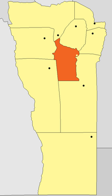 Location of Coronel Pringles Department in San Luis Province | |
| Coordinates: 33°3′S 65°37′W / 33.050°S 65.617°W / -33.050; -65.617 | |
| Argentina |  Argentina Argentina |
| Province |  San Luis San Luis |
| Seat | La Toma |
| Area | |
| • Total | 4,484 km2 (1,731 sq mi) |
| Population [1] | 12,571 |
'Coronel Pringles is a department of San Luis Province, Argentina.
With an area of 4,484 km2 (1,731 sq mi) it borders to the north with the departments of Ayacucho and San Martín, to the east with Chacabuco and General Pedernera, to the south with Pedernera, and to the west with Juan Martín de Pueyrredón, and Belgrano.
Municipalities
- Carolina
- El Trapiche
- Estancia Grande[2]
- Fraga
- La Bajada
- La Florida
- La Toma
- Riocito
- Saladillo
Villages
- Arroyo Barranquita
- Balde de la Isla
- Baldecitos
- Cañada Honda
- Comandante Granville
- Cuatro Esquinas
- El Amago
- El Durazno
- El Manantial
- El Zapallar
- Eleodoro Lobos
- Juan Gez
- La Arenilla
- La Atalaya
- La Cumbre
- La Petra
- La Puerta
- Las Totoras
- Los Membrillos
- Los Pocitos
- Pampa del Tamboreo
- Paso de las Carretas
- Paso del Rey
- Puerta de Pancanta
- Río Grande
- San Gregorio
- Valle de Pancanta
- Virorco
- El Guanaco
References
External links
- Provincial website
- v
- t
- e

 | This article about a place in San Luis Province, Argentina is a stub. You can help Wikipedia by expanding it. |
- v
- t
- e


