Cremorne Railway Bridge
Bridge in Melbourne, Australia
37°50′01″S 144°59′35″E / 37.8336°S 144.993°E / -37.8336; 144.993
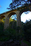
The Cremorne Railway Bridge crosses the Yarra River three kilometres south-east of Melbourne connecting Richmond and South Yarra stations on the Frankston, Pakenham, Cranbourne, and Sandringham railway lines.
History
The first bridge on the site was a double-track structure, opened in December 1860 by the Melbourne and Suburban Railway Company.[1][2] In 1886, a second double-track bridge was opened alongside the first, thereby allowing a four-track section of line to be provided between Richmond and South Yarra.[3] The present bridge was opened in 1946.[4] It accommodated three pairs of tracks between Richmond and South Yarra, although the two extra tracks were not constructed until 1960.[5]
References
- ^ "MELBOURNE AND SUBURBAN RAILWAY COMPANY". The Argus (Melbourne). No. 4, 280. Victoria, Australia. 29 February 1860. p. 7. Retrieved 22 April 2017 – via National Library of Australia.
- ^ "THE CREMORNE RAILWAY BRIDGE". The Argus (Melbourne). No. 12, 474. Victoria, Australia. 18 June 1886. p. 7. Retrieved 22 April 2017 – via National Library of Australia.
- ^ "The Cremorne Railway Bridge". The Argus. Melbourne, Vic. 18 June 1886. p. 7. Retrieved 19 November 2011.
- ^ "Photo:FIRST SECTION". The Argus. Melbourne, Vic. 5 June 1946. p. 15. Retrieved 19 November 2011., ...of new Cremorne railway bridge over Yarra is now in use after 2 years' work...
- ^ "Sth Yarra". Victorian Railways . net. Mark Bau. Retrieved 19 August 2019.
- v
- t
- e
Crossings of the Yarra River in Melbourne
- Bolte Bridge
- Burke Road Bridge
- Burnley Tunnel
- Chandler Highway Bridges
- Charles Grimes Bridge
- Church Street Bridge
- Collins Bridge
- Cremorne Railway Bridge
- Darebin Creek Trail Footbridge
- Diamond Creek Trail Footbridge
- Domain Tunnel
- Eastern Freeway Bridges
- Evan Walker Bridge
- Fairfield Pipe Bridge
- Fitzsimons Lane Bridge
- Gardiners Creek Trail Footbridge
- Hawthorn Bridge
- Hawthorn Railway Bridge
- Heyington Rail Bridge
- Hoddle Bridge
- Johnston Street Bridge
- Kanes Bridge
- King Street Bridge
- MacRobertson Bridge
- Manningham Road Bridge
- Monash Freeway
- Morell Bridge
- Princes Bridge
- Queens Bridge
- Ruffey Trail Suspension Bridge
- Sandridge Bridge
- Seafarers Bridge
- Spencer Street Bridge
- Spotswood sewer tunnel
- Swan Street Bridge
- Swan Street/Wallen Road Bridge
- Victoria Bridge
- Walmer Street Footbridge
- Warrandyte Bridge
- Webb Bridge
- West Gate Bridge
- Westerfolds Park Footbridge
Railway bridges in Australia | ||
|---|---|---|
| New South Wales former |
|  |
| Northern Territory | ||
| Queensland | ||
| South Australia former | ||
| Tasmania |
| |
| Victoria former | ||
| Western Australia former |
| |
37°50′1″S 144°59′36″E / 37.83361°S 144.99333°E / -37.83361; 144.99333


