Day Pond State Park
State park in New London County, Connecticut
41°33′24″N 72°25′08″W / 41.55667°N 72.41889°W / 41.55667; -72.41889[1]
Day Pond State Park is a public recreation area covering 180 acres (73 ha) in the town of Colchester, Connecticut. The state park abuts Salmon River State Forest and is managed by the Connecticut Department of Energy and Environmental Protection. The park offers opportunities for hiking, swimming, shoreline fishing, picnicking and mountain biking.[3][4]
History
Foundation stones and the park's pond are the few remaining signs of the pioneering Day family, who built the pond to provide waterpower to operate the family sawmill. The land became a state park in 1949.[3]
Activities and amenities
The park is designated for trout management and offers shoreline fishing on Day Pond.[5] The pond covers about 7 acres (2.8 ha) and reaches a depth of a little over 10 feet (3.0 m).[6] Park trails connect with approximately five miles of trails in the adjoining state forest.[7]
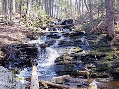
Day Pond Brook Falls
A multi-drop waterfall can be found along Day Pond Brook, dropping a total height of 40 feet (12 meters). The falls were once not well known and could not be accessed without bushwhacking. But in 2010, a spur trail was created by a Boy Scout to provide easier access to the falls for the public.[8]
Gallery


References
- ^ a b "Day Pond". Geographic Names Information System. United States Geological Survey, United States Department of the Interior.
- ^ "Appendix A: List of State Parks and Forests" (PDF). State Parks and Forests: Funding. Staff Findings and Recommendations. Connecticut General Assembly. January 23, 2014. p. A-1. Retrieved March 20, 2014.
- ^ a b "Day Pond State Park". Connecticut Department of Energy and Environmental Protection. Retrieved August 6, 2024.
- ^ "Day Pond State Park". Connecticut Department of Energy and Environmental Protection. Archived from the original on March 4, 2016. Retrieved August 3, 2016.
- ^ "2024 Fishing Guide" (PDF). Connecticut Department of Energy and Environmental Protection. April 24, 2024. p. 15. Retrieved August 6, 2024.
- ^ "Day Pond" (PDF). Connecticut Department of Energy and Environmental Protection. September 2011. Retrieved September 12, 2017.
- ^ "Day Pond State Park Map" (PDF). Connecticut Department of Energy and Environmental Protection. May 12, 2014. Retrieved December 18, 2015.
- ^ Parsons, Greg. "Day Pond Brook Falls". New England Waterfalls.
External links
Wikimedia Commons has media related to Day Pond State Park.
- Day Pond State Park Connecticut Department of Energy and Environmental Protection
- Day Pond State Park Map Connecticut Department of Energy and Environmental Protection
- v
- t
- e
Protected areas of Connecticut
- Appalachian Trail
- New England National Scenic Trail
- Washington–Rochambeau Revolutionary Route
- Above All
- Air Line
- Beaver Brook
- Becket Hill State Park Reserve
- Beckley Furnace Industrial Monument
- Bennett's Pond
- Bigelow Hollow
- Black Rock
- Bluff Point
- Bolton Notch
- Brainard Homestead
- Burr Pond
- Camp Columbia
- Campbell Falls
- Chatfield Hollow
- Collis P. Huntington
- Connecticut Valley Railroad
- Dart Island State Park
- Day Pond
- Dennis Hill
- Devil's Hopyard
- Dinosaur
- Eagle Landing
- Farm River
- Farmington Canal
- Fort Griswold Battlefield
- Fort Trumbull
- Gardner Lake
- Gay City
- George Dudley Seymour
- George Waldo
- Gillette Castle
- Haddam Island
- Haddam Meadows
- Haley Farm
- Hammonasset Beach
- Harkness Memorial
- Haystack Mountain
- Higganum Reservoir
- Hop River State Park Trail
- Hopemead
- Hopeville Pond
- Horse Guard
- Housatonic Meadows
- Humaston Brook
- Hurd
- Indian Well
- John A. Minetto
- Kent Falls
- Kettletown
- Killingly Pond
- Lake Waramaug
- Lamentation Mountain
- Larkin State Park Trail
- Lovers Leap
- Macedonia Brook
- Machimoodus
- Mansfield Hollow
- Mashamoquet Brook
- Mianus River
- Millers Pond
- Minnie Island
- Mohawk Mountain
- Mono Pond
- Moosup Valley State Park Trail
- Mooween
- Mount Bushnell
- Mount Riga
- Mount Tom
- Old Furnace
- Osbornedale
- Penwood
- Platt Hill
- Pomeroy
- Putnam Memorial
- Quaddick
- Quinebaug Lake
- Quinnipiac River
- River Highlands
- Rocky Glen
- Rocky Neck
- Ross Pond
- Salt Rock State Campground
- Satan's Kingdom State Recreation Area
- Scantic River
- Selden Neck
- Seth Low Pierrepont
- Sherwood Island
- Silver Sands
- Sleeping Giant
- Southford Falls
- Squantz Pond
- Stillwater Pond
- Stoddard Hill
- Stratton Brook
- Sunnybrook
- Sunrise
- Talcott Mountain
- Tri-Mountain
- Trout Brook Valley
- Wadsworth Falls
- West Rock Ridge
- Wharton Brook
- Whittemore Glen
- Windsor Locks Canal State Park Trail
- Windsor Meadows
- Wooster Mountain
- Algonquin
- American Legion
- Centennial Watershed
- Cockaponset
- Enders
- James L. Goodwin
- Housatonic
- Massacoe
- Mattatuck
- Meshomasic
- Mohawk
- Mohegan
- Nassahegon
- Natchaug
- Nathan Hale
- Naugatuck
- Nehantic
- Nepaug
- Nipmuck
- Nye-Holman
- Pachaug
- Paugnut
- Paugussett
- People's
- Pootatuck
- Quaddick
- Salmon River
- Shenipsit
- Topsmead
- Tunxis
- Wyantenock
- Aldo Leopold WMA
- Assekonk WMA
- Babcock Pond WMA
- Barber Pond WMA
- Barn Island WMA
- Bartlett Brook WMA
- Bear Hill WMA
- Belding WMA
- Bishops Swamp WMA
- Black Pond WMA
- Candlewood Hill WMA
- Cedar Swamp WMA
- Charles E. Wheeler WMA
- Cromwell Meadows WMA
- Durham Meadows WMA
- East River Marsh WMA
- East Swamp WMA
- Eightmile River WMA
- Franklin Swamp WMA
- Goshen WMA
- Great Harbor WMA
- Higganum Meadows WMA
- Housatonic River WMA
- King's Island Coop WMA
- Kollar WMA
- Larson Lot WMA
- Little River Fish and Wildlife Area
- Lord's Cove WMA
- Maromas Coop WMA
- Meadow Brook WMA
- Menunketesuck WMA
- Messerschmidt WMA
- Newgate WMA
- Nod Brook WMA
- Nott Island WMA
- Pease Brook WMA
- Plum Bank WMA
- Quinebaug River WMA
- Quinnipiac River Marsh WMA
- Ragged Rock WMA
- Raymond Brook Marsh WMA
- Robbins Swamp WMA
- Roger Tory Peterson Wildlife Area
- Roraback WMA
- Rose Hill WMA
- Ross Marsh WMA
- Salmon River Cove and Haddam Neck WMA
- Sessions Woods WMA
- Simsbury WMA
- Skiff Mountain Coop WMA
- James V. Spignesi WMA
- Stanley Works WMA
- Suffield WMA
- Talbot WMA
- Tankerhoosen WMA
- Wangunk Meadows WMA
- Wopowog WMA
- Zemko Pond WMA
- Aspetuck Reservoir
- Barkhamsted Reservoir
- Beaver Dam Lake
- Candlewood Lake
- Easton Reservoir
- Far Mill Reservoir
- Hemlock Reservoir
- Hop Brook Lake
- Lake Lillinonah
- Mansfield Hollow Lake
- Means Brook
- Saugatuck Reservoir
- Trap Falls Reservoir
- West Hartford Reservoir
- West Pequonnock Reservoir
- Lake Zoar
- Aspetuck Land Trust
- Aton Forest
- Audubon Center at Bent of the River
- Bartlett Arboretum and Gardens
- Bear Mountain
- Beckley Bog
- Branford Land Trust
- Case Mountain
- Cathedral Pines
- Connecticut Audubon Society Center at Fairfield
- Connecticut College Arboretum
- Devil's Den Preserve
- Earthplace
- Great Mountain Forest
- Higby Mountain
- Highstead Arboretum
- Joshua's Tract Conservation and Historic Trust
- McLean Game Refuge
- New Canaan Nature Center
- Peter's Rock
- Pine Mountain Reserve
- Saltonstall Mountain
- Stamford Museum & Nature Center
- Steep Rock Association
- Weantinoge Heritage Land Trust
- White Memorial Foundation
- Woodcock Nature Center
- Yale-Myers Forest
- American Legion State Forest Trails
- Aspetuck Valley Trail
- Blue-Blazed Trails
- Chatfield Trail
- Hancock Brook Trail
- Housatonic Range Trail
- Lillinonah Trail
- Mattabesett Trail
- Menunkatuck Trail
- Metacomet Trail
- Narragansett Trail
- Natchaug Trail
- Naugatuck Trail
- Nehantic Trail
- Nipmuck Trail
- Paugussett Trail
- Pequot Trail
- Quinnipiac Trail
- Regicides Trail
- Salmon River Trail
- Shenipsit Trail
- Tunxis Trail
- Westwoods Trails
- Whitestone Cliffs Trail
- Zoar Trail
Forest/Parks
- Bear Mountain Reservation
- Beardsley Park
- Burr Farm Protected Open Space
- East Rock Park
- Gurski Farm Protected Open Space
- Happy Landings Protected Open Space
- Lighthouse Point Park
- Lillinonah Woods
- Mill River Park
- Old Bridge Sanctuary
- Pleasure Beach
- Roosevelt Forest
- Salt Meadow Park
- Seaside Park
- Webb Mountain Discovery Zone
- Webb Mountain Park


