Deep Creek National Park
Protected area in South Australia
35°37′40″S 138°13′19″E / 35.62778°S 138.22194°E / -35.62778; 138.22194Deep Creek National Park, formerly the Deep Creek Conservation Park, is a protected area in the Australian state of South Australia located on the southern coast of Fleurieu Peninsula in the gazetted localities of Deep Creek and Delamere about 11 kilometres (6.8 miles) east of Cape Jervis.[2][3]
History
Formerly a conservation park known as Deep Creek Conservation Park, it was renamed Deep Creek National Park upon being proclaimed a national park on 26 November 2021[6][7]
Description
The park is the largest portion of remaining natural vegetation on the Fleurieu Peninsula, and is home to much native wildlife, including western grey kangaroos, short-beaked echidnas and around 100 species of birds.[8]
The park encompasses 18 kilometres (11 miles) of coastline, which include views across Backstairs Passage to Kangaroo Island. The conservation park consists of mainly rolling coastal hills, the gullies of which contain orchids and ferns, while the hilltops have stunted scrub and low windswept trees. Walking trails (including part of the famous Heysen Trail) provide access to most of the conservation park.[citation needed]
It is classified as an IUCN class II protected area.[1] In 1980, it was listed on the now-defunct Register of the National Estate.[9]
Camping
The conservation park has five camping areas available with various facilities.[citation needed]
- Stringybark: A sheltered forest setting with 16 sites, hot showers, toilets and rain water. Sites available for caravans and camp trailers. No powered sites available.
- Trig: Central to the main hiking trails, open grassy areas with many well-sheltered and shady sites. 25 sites, toilets and rain water available. Sites available for caravans and camp trailers. No powered sites available.
- Tapanappa: 18 moderately sheltered sites with spectacular coastal views close by. Toilets and rain water available.
- Cobbler Hill: 10 sites with toilets and rain water close to Blowhole Beach. Can be exposed during windy conditions.
- Eagle Waterhole: Located on the Heysen Trail, and only able to be used by hikers. A hikers' hut and rainwater tank have been erected at this site.
Gallery
-
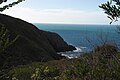 Approaching the cove at the mouth of Deep Creek.
 -
 Looking south.
 -
 The creek mouth.
 -
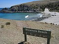 Blowhole Beach.
 -
 Blowhole Beach looking North East.


See also
- Deep Creek (disambiguation)
References
Notes
- ^ Visitor numbers shared with Talisker Conservation Park
Citations
- ^ a b "Terrestrial Protected Areas of South Australia (refer 'DETAIL' tab )". CAPAD 2016. Australian Government, Department of the Environment (DoE). 2016. Retrieved 21 February 2018.
- ^ a b "Search result for "Deep Creek Conservation Park" (Record no SA0019531) with the following layers selected - "Suburbs and Localities" and " Place names (gazetteer)"". Property Location Browser. Government of South Australia. Archived from the original on 12 October 2016. Retrieved 8 August 2016.
- ^ a b Shard, A.J. (30 September 1971). "NATIONAL PARKS ACT, 1966: DECLARATION OF NATIONAL PARK" (PDF). The South Australian Government Gazette. Government of South Australia. p. 1226. Retrieved 11 January 2019.
- ^ "Protected Areas Information System - reserve list (as of 17 Feb 2014)" (PDF). Department of Environment Water and Natural Resources. p. 5. Archived from the original (PDF) on 2 July 2015. Retrieved 16 March 2014.
- ^ Deep Creek and Talisker Conservation Parks management plan, Fleurieu, South Australia (PDF), Department of Environment and Natural Resources (South Australia), 1997, p. 20, ISBN 978-0-7308-5830-0, retrieved 25 September 2019
- ^ Speirs, David (26 November 2021). "SA now home to Australia's biggest national park". Premier of South Australia. Archived from the original on 19 December 2021. Retrieved 19 December 2021.
 Text may have been copied from this source, which is available under a Attribution 3.0 Australia (CC BY 3.0 AU) licence.
 - ^ Gooch, Declan (26 November 2021). "Australia's biggest national park declared in South Australia's far north". ABC News. Australian Broadcasting Corporation. Retrieved 19 December 2021.
- ^ "Deep Creek National Park". National Parks and Wildlife Service South Australia. Retrieved 19 December 2021. Text may have been copied from this source, which is available under a Attribution 3.0 Australia (CC BY 3.0 AU) licence.
- ^ "Deep Creek Conservation Park, Blowhole Creek Rd, Cape Jervis (sic), SA, Australia - listing on the now-defunct Register of the National Estate (Place ID 7782)". Australian Heritage Database. Australian Government. 21 October 1980. Retrieved 27 September 2019.
External links
 Deep Creek National Park travel guide from Wikivoyage
- Official website
- Protected Planet website
- BirdsSA website
- v
- t
- e
- Adelaide International Bird Sanctuary–Winaityinaityi Pangkara
- Belair
- Canunda
- Cleland
- Coffin Bay
- Coorong
- Dhilba Guuranda-Innes
- Flinders Chase
- Deep Creek
- Glenthorne National Park–Ityamaiitpinna Yarta
- Gawler Ranges
- Great Australian Bight Marine
- Ikara-Flinders Ranges
- Kati Thanda-Lake Eyre
- Lake Frome
- Lake Gairdner
- Lake Torrens
- Lincoln
- Malkumba-Coongie
- Mount Remarkable
- Munga-Thirri–Simpson Desert
- Murray River
- Naracoorte Caves
- Nullarbor
- Nilpena Ediacara
- Onkaparinga River
- Vulkathunha-Gammon Ranges
- Wapma Thura–Southern Flinders Ranges
- Witjira
- Aberdour
- Acraman Creek
- Aldinga Scrub
- Althorpe Islands
- Angove
- Avoid Bay Islands
- Baird Bay Islands
- Bakara
- Bandon
- Bangham
- Barwell
- Bascombe Well
- Baudin
- Baudin Rocks
- Beachport
- Beatrice Islet
- Belt Hill
- Beyeria
- Big Heath
- Billiatt
- Bimbowrie
- Bird Islands
- Black Hill
- Black Rock
- Boondina
- Breakaways
- Brookfield
- Bullock Hill
- Busby Islet
- Butchers Gap
- Calectasia
- Calpatanna Waterhole
- Cap Island
- Cape Blanche
- Cape Gantheaume
- Cape Willoughby
- Caralue Bluff
- Carappee Hill
- Carcuma
- Caroona Creek
- Carpenter Rocks
- Carribie
- Chadinga
- Charleston
- Christmas Rocks
- Clements Gap
- Clinton
- Cocata
- Cooltong
- Corrobinnie Hill
- Cox Scrub
- Cromer
- Cudlee Creek
- Custon
- Cygnet Estuary
- Danggali
- Darke Range
- Desert Camp
- Dingley Dell
- Douglas Point
- Dudley
- Eba Island
- Elliot Price
- Eric Bonython
- Ettrick
- Ewens Ponds
- Fairview
- Ferguson
- Ferries-McDonald
- Finniss
- Fort Glanville
- Fowlers Bay
- Franklin Harbor
- Furner
- Gambier Islands
- Gawler Ranges
- Geegeela
- Giles
- Glen Roy
- Goose Island
- Gower
- Grass Tree
- Greenly Island
- Guichen Bay
- Gum Lagoon
- Gum Tree Gully
- Hacks Lagoon
- Hale
- Hallett Cove
- Hanson Scrub
- Heggaton
- Hesperilla
- Hincks
- Hogwash Bend
- Hopkins Creek
- Horsnell Gully
- Ironstone Hill
- Jip Jip
- Kaiserstuhl
- Kapunda Island
- Karte
- Kathai
- Kellidie Bay
- Kelly Hill
- Kelvin Powrie
- Kenneth Stirling
- Kinchina
- Kulliparu
- Kungari
- Kyeema
- Lake Frome
- Lake Gilles
- Lake Hawdon South
- Lake Newland
- Lake St Clair
- Lashmar
- Lathami
- Laura Bay
- Lawari
- Lesuer
- Leven Beach
- Lincoln
- Lipson Island
- Little Dip
- Lowan
- Lower Glenelg River
- Maize Island Lagoon
- Malgra
- Mamungari
- Mantung
- Marino
- Mark Oliphant
- Marne Valley
- Martin Washpool
- Martindale Hall
- Mary Seymour
- Media Island
- Messent
- Middlecamp Hills
- Mimbara
- Minlacowie
- Moana Sands
- Mokota
- Monarto
- Monarto Woodlands
- Montacute
- Moody Tank
- Morgan
- Morialta
- Mount Billy
- Mount Boothby
- Mount Brown
- Mount Dutton Bay
- Mount George
- Mount Magnificent
- Mount Monster
- Mount Scott
- Mount Taylor
- Mowantjie Willauwar
- Mullinger Swamp
- Munyaroo
- Murrunatta
- Mylor
- Myponga
- Nene Valley
- Nepean Bay
- Neptune Islands
- Newland Head
- Ngarkat
- Ngaut Ngaut
- Nicolas Baudin Island
- Nixon-Skinner
- Nuyts Archipelago
- Nuyts Reef
- Olive Island
- Padthaway
- Pandappa
- Para Wirra
- Paranki Lagoon
- Parndana
- Peachna
- Peebinga
- Pelican Lagoon
- Penambol
- Penguin Island
- Penola
- Piccaninnie Ponds
- Pigface Island
- Pike River
- Pine Hill Soak
- Pinkawillinie
- Point Bell
- Point Davenport
- Point Labatt
- Pooginook
- Poonthie Ruwe
- Porter Scrub
- Pualco Range
- Pullen Island
- Pureba
- Ramco Point
- Ramsay
- Red Banks
- Reedy Creek
- Ridley
- Rilli Island
- Rocky Island (North)
- Rocky Island (South)
- Roonka
- Rudall
- Salt Lagoon Islands
- Sandy Creek
- Sceale Bay
- Scott
- Scott Creek
- Seal Bay
- Searcy Bay
- Seddon
- Shannon
- Sheoak Hill
- Simpson
- Sinclair Island
- Sir Joseph Banks Group
- Sleaford Mere
- Spring Gully
- Spring Mount
- Stipiturus
- Swan Reach
- Talapar
- Talisker
- Tallaringa
- Tantanoola Caves
- Telford Scrub
- The Dutchmans Stern
- The Knoll
- The Pages
- The Plug Range
- Thidna
- Tilley Swamp
- Torrens Island
- Troubridge Island
- Tucknott Scrub
- Tumby Island
- Venus Bay
- Verran Tanks
- Vivigani Ardune
- Vivonne Bay
- Wabma Kadarbu Mound Springs
- Wahgunyah
- Waitpinga
- Waldegrave Islands
- Wanilla
- Wanilla Land Settlement
- Warren
- Warrenben
- West Island
- Wharminda
- Whidbey Isles
- White Dam
- Whyalla
- Wiljani
- Wills Creek
- Winninowie
- Wittelbee
- Woakwine
- Wolseley Common
- Yalpara
- Yeldulknie
- Yulte
- Yumbarra
- Marine protected areas of South Australia
- List of protected areas in Adelaide


