Drake County
Map all coordinates using OpenStreetMap
Download coordinates as:
- KML
- GPX (all coordinates)
- GPX (primary coordinates)
- GPX (secondary coordinates)
Cadastral in New South Wales, Australia
| Drake New South Wales | |||||||||||||||
|---|---|---|---|---|---|---|---|---|---|---|---|---|---|---|---|
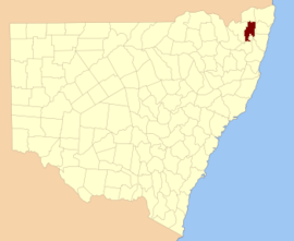 Location in New South Wales | |||||||||||||||
| |||||||||||||||
Drake County is one of the 141 cadastral divisions of New South Wales.
Drake County was named in honour of Sir Francis Drake (1540–1596).[1] It is located to the north of parts of the Clarence River, Nymboida River and Mann River. It includes the Washpool National Park.
Parishes within this county
A full list of parishes found within this county; their current LGA and mapping coordinates to the approximate centre of each location is as follows:
| Parish | LGA | Coordinates |
|---|---|---|
| Albert | Glen Innes Severn Council | 29°23′54″S 152°21′04″E / 29.39833°S 152.35111°E / -29.39833; 152.35111 (Albert) |
| Alice | Clarence Valley Council | 29°02′54″S 152°38′04″E / 29.04833°S 152.63444°E / -29.04833; 152.63444 (Alice) |
| Black Camp | Kyogle Council | 28°48′54″S 152°43′04″E / 28.81500°S 152.71778°E / -28.81500; 152.71778 (Black Camp) |
| Cangai | Clarence Valley Council | 29°36′54″S 152°30′04″E / 29.61500°S 152.50111°E / -29.61500; 152.50111 (Cangai) |
| Carnham | Clarence Valley Council | 29°16′54″S 152°30′04″E / 29.28167°S 152.50111°E / -29.28167; 152.50111 (Carnham) |
| Chauvel | Tenterfield Shire Council | 28°55′54″S 152°32′04″E / 28.93167°S 152.53444°E / -28.93167; 152.53444 (Chauvel) |
| Churchill | Clarence Valley Council | 29°10′54″S 152°30′04″E / 29.18167°S 152.50111°E / -29.18167; 152.50111 (Churchill) |
| Coombadjha | Clarence Valley Council | 29°22′54″S 152°28′04″E / 29.38167°S 152.46778°E / -29.38167; 152.46778 (Coombadjha) |
| Coongbar | Clarence Valley Council | 29°04′54″S 152°42′04″E / 29.08167°S 152.70111°E / -29.08167; 152.70111 (Coongbar) |
| Cooraldooral | Glen Innes Severn Council | 29°34′54″S 152°16′04″E / 29.58167°S 152.26778°E / -29.58167; 152.26778 (Cooraldooral) |
| Dandahra | Clarence Valley Council | 29°29′54″S 152°26′04″E / 29.49833°S 152.43444°E / -29.49833; 152.43444 (Dandahra) |
| Drake | Tenterfield Shire Council | 29°00′54″S 152°25′04″E / 29.01500°S 152.41778°E / -29.01500; 152.41778 (Drake) |
| Dunbar | Tenterfield Shire Council | 28°57′54″S 152°31′04″E / 28.96500°S 152.51778°E / -28.96500; 152.51778 (Dunbar) |
| Ewingar | Clarence Valley Council | 29°05′54″S 152°30′04″E / 29.09833°S 152.50111°E / -29.09833; 152.50111 (Ewingar) |
| Fairfield | Tenterfield Shire Council | 28°54′54″S 152°27′04″E / 28.91500°S 152.45111°E / -28.91500; 152.45111 (Fairfield) |
| Hamilton | Tenterfield Shire Council | 29°01′54″S 152°30′04″E / 29.03167°S 152.50111°E / -29.03167; 152.50111 (Hamilton) |
| Hassan | Clarence Valley Council | 29°20′54″S 152°45′04″E / 29.34833°S 152.75111°E / -29.34833; 152.75111 (Hassan) |
| Hongkong | Tenterfield Shire Council | 29°06′54″S 152°24′04″E / 29.11500°S 152.40111°E / -29.11500; 152.40111 (Hongkong) |
| Keybarbin | Clarence Valley Council | 29°06′54″S 152°38′04″E / 29.11500°S 152.63444°E / -29.11500; 152.63444 (Keybarbin) |
| Malara | Tenterfield Shire Council | 29°12′54″S 152°22′04″E / 29.21500°S 152.36778°E / -29.21500; 152.36778 (Malara) |
| Mookima | Clarence Valley Council | 29°14′54″S 152°43′04″E / 29.24833°S 152.71778°E / -29.24833; 152.71778 (Mookima) |
| Neville | Clarence Valley Council | 29°15′54″S 152°46′04″E / 29.26500°S 152.76778°E / -29.26500; 152.76778 (Neville) |
| Ogilvie | Clarence Valley Council | 29°11′54″S 152°38′04″E / 29.19833°S 152.63444°E / -29.19833; 152.63444 (Ogilvie) |
| Picarbin | Kyogle Council | 28°57′54″S 152°36′04″E / 28.96500°S 152.60111°E / -28.96500; 152.60111 (Picarbin) |
| Pikapene | Kyogle Council | 28°58′54″S 152°42′04″E / 28.98167°S 152.70111°E / -28.98167; 152.70111 (Pikapene) |
| Plevna | Clarence Valley Council | 29°17′54″S 152°22′04″E / 29.29833°S 152.36778°E / -29.29833; 152.36778 (Plevna) |
| Pucka | Clarence Valley Council | 29°20′54″S 152°35′04″E / 29.34833°S 152.58444°E / -29.34833; 152.58444 (Pucka) |
| Puhoi | Clarence Valley Council | 29°35′54″S 152°24′04″E / 29.59833°S 152.40111°E / -29.59833; 152.40111 (Puhoi) |
| Pulganbar | Clarence Valley Council | 29°26′54″S 152°41′04″E / 29.44833°S 152.68444°E / -29.44833; 152.68444 (Pulganbar) |
| Richmond | Glen Innes Severn Council | 29°29′54″S 152°21′04″E / 29.49833°S 152.35111°E / -29.49833; 152.35111 (Richmond) |
| Rodgers | Glen Innes Severn Council | 29°38′54″S 152°14′04″E / 29.64833°S 152.23444°E / -29.64833; 152.23444 (Rodgers) |
| Rodham | Clarence Valley Council | 29°09′54″S 152°43′04″E / 29.16500°S 152.71778°E / -29.16500; 152.71778 (Rodham) |
| Sandilands | Kyogle Council | 28°54′54″S 152°42′04″E / 28.91500°S 152.70111°E / -28.91500; 152.70111 (Sandilands) |
| Sistova | Tenterfield Shire Council | 29°13′54″S 152°16′04″E / 29.23167°S 152.26778°E / -29.23167; 152.26778 (Sistova) |
| Tabulam | Kyogle Council | 28°52′54″S 152°37′04″E / 28.88167°S 152.61778°E / -28.88167; 152.61778 (Tabulam) |
| Timbarra | Tenterfield Shire Council | 28°52′54″S 152°30′04″E / 28.88167°S 152.50111°E / -28.88167; 152.50111 (Timbarra) |
| West Fairfield | Tenterfield Shire Council | 28°55′54″S 152°22′04″E / 28.93167°S 152.36778°E / -28.93167; 152.36778 (West Fairfield) |
| Yarrcalkiarra | Clarence Valley Council | 29°16′54″S 152°39′04″E / 29.28167°S 152.65111°E / -29.28167; 152.65111 (Yarrcalkiarra) |
| Yulgilbar | Clarence Valley Council | 29°16′54″S 152°34′04″E / 29.28167°S 152.56778°E / -29.28167; 152.56778 |
References
- ^ "Drake". Geographical Names Register (GNR) of NSW. Geographical Names Board of New South Wales. Retrieved 4 August 2013.


