East Columbia, Texas
Place in Texas, United States
29°08′29″N 95°36′57″W / 29.14139°N 95.61583°W / 29.14139; -95.61583 (2020)

East Columbia is an unincorporated community and census designated place (CDP) in Brazoria County, Texas, United States. It is located nine miles west of Angleton. It was one of the most important inland ports in Texas. The river port became a vital component in the plantation-based economy that developed along the Brazos River in the 19th century. The community was founded in 1824 by Josiah Hughes Bell. A native of South Carolina, Bell came to Texas with Stephen F. Austin's Old 300 colony in 1821. Bell built a landing of log-lines docks and timbered stops on the Brazos River, just below Varner's Creek. Bell laid out the town and called it Marion. Bell sold the townsite to Walter C. White in 1827. By the mid-1800s, the town had a population of 800. The arrival of the railroad in the area led to the decline of steamboat traffic, which had an adverse effect on the town's fortunes. Storms in 1900, 1909, and 1913 were destructive to the community. When oil was discovered in West Columbia in 1918, merchants abandoned East Columbia. By the 1970s, the town's post office had already closed and its population had decreased substantially.
Demographics
| Census | Pop. | Note | %± |
|---|---|---|---|
| 2020 | 128 | — | |
| U.S. Decennial Census[1] 1850–1900[2] 1910[3] 1920[4] 1930[5] 1940[6] 1950[7] 1960[8] 1970[9] 1980[10] 1990[11] 2000[12] 2010[13] | |||
Education
Columbia-Brazoria Independent School District operates schools in the area.[14]
The Texas Legislature assigned the area in Columbia-Brazoria ISD (including West Columbia) to the Brazosport College district.[15]
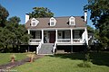
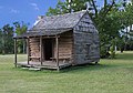
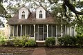
Photo gallery


References
- ^ "Decennial Census by Decade". United States Census Bureau.
- ^ "1900 Census of Population - Population of Texas By Counties And Minor Civil Divisions" (PDF). United States Census Bureau.
- ^ "1910 Census of Population - Supplement for Texas" (PDF). United States Census Bureau.
- ^ "1920 Census of Population - Number of Inhabitants - Texas" (PDF). United States Census Bureau.
- ^ "1930 Census of Population - Number of Inhabitants - Texas" (PDF). United States Census Bureau.
- ^ "1940 Census of Population - Number of Inhabitants - Texas" (PDF). United States Census Bureau.
- ^ "1950 Census of Population - Number of Inhabitants - Texas" (PDF). United States Census Bureau.
- ^ "1960 Census of Population - Number of Inhabitants - Texas" (PDF). United States Census Bureau.
- ^ "1970 Census of Population - Number of Inhabitants - Texas" (PDF). United States Census Bureau.
- ^ "1980 Census of Population - Number of Inhabitants - Texas" (PDF). United States Census Bureau.
- ^ "1990 Census of Population - Population and Housing Unit Counts - Texas" (PDF). United States Census Bureau.
- ^ "2000 Census of Population - Population and Housing Unit Counts - Texas" (PDF). United States Census Bureau.
- ^ "2010 Census of Population - Population and Housing Unit Counts - Texas" (PDF). United States Census Bureau.
- ^ "2020 CENSUS - SCHOOL DISTRICT REFERENCE MAP: Brazoria County, TX" (PDF). U.S. Census Bureau. Retrieved April 19, 2021.
- ^ Texas Education Code Sec. 130.170. BRAZOSPORT COLLEGE DISTRICT SERVICE AREA.
External links
- Merle Weir: East Columbia, Texas from the Handbook of Texas Online (June 12, 2010)
- v
- t
- e
Municipalities and communities of Brazoria County, Texas, United States
County seat: Angleton

- Damon
- East Columbia
- Rosharon
- Wild Peach Village
communities
- Hasima
- Hastings
- Lake Barbara
- Mims
- Perry Landing
- Velasco
‡This populated place also has portions in an adjacent county or counties
- Texas portal
- United States portal
 | This article about a location in Brazoria County, Texas is a stub. You can help Wikipedia by expanding it. |
- v
- t
- e


