Emsworth Locks and Dam
Dam
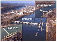
40°30′12″N 80°05′22″W / 40.5033°N 80.0895°W / 40.5033; -80.0895Emsworth Locks and Dam is a combination of locks and dam on the Ohio River located just downstream of Pittsburgh. The dam has two gated sections, one on each side of Neville Island. There are two locks, one for commercial barge traffic that is 600 feet long by 110 feet wide, and the recreational auxiliary lock that is 360 feet long by 56 feet wide.[1] Emsworth averages about 470 commercial lock throughs every month and 350-400 lock throughs a month on the recreational auxiliary lock.[2]
See also
References
External links
Wikimedia Commons has media related to Emsworth Lock and Dam.
- U.S. Army Corps of Engineers, Pittsburgh District
- U.S. Army Corps of Engineers, Huntington District
- U.S. Army Corps of Engineers, Louisville District
- Historic American Engineering Record, Emsworth Locks and Dams, Locks and Main Channel Dam, Ohio River Mile Marker 6.2, Emsworth, Allegheny County, PA
- Historic American Engineering Record, Emsworth Locks and Dams, At Ohio River Mile Markers 6.2 and 6.81, Emsworth, Allegheny County, PA
- Historic American Engineering Record, Emsworth Locks and Dams, Back Channel Dam, Ohio River at Mile Marker 6.31, Emsworth, Allegheny County, PA
- v
- t
- e
Locks and dams of the Ohio River
- Emsworth
- Dashields
- Montgomery
- New Cumberland
- Pike Island
- Hannibal
- Willow Island
- Belleville
- Racine
- Byrd
- Greenup
- Meldahl
- Markland
- McAlpine
- Cannelton
- Newburgh
- Myers
- Smithland
- Olmsted
| Upstream: None on the Ohio River | Downstream: Dashields Locks and Dam |


