Fitzroy County
Map all coordinates using OpenStreetMap
Download coordinates as:
- KML
- GPX (all coordinates)
- GPX (primary coordinates)
- GPX (secondary coordinates)
Cadastral in New South Wales, Australia
| Fitzroy New South Wales | |||||||||||||||
|---|---|---|---|---|---|---|---|---|---|---|---|---|---|---|---|
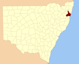 Location in New South Wales | |||||||||||||||
| |||||||||||||||
Fitzroy County is one of the 141 cadastral divisions of New South Wales. It lies south of the Orara River, and north of the Bellinger River, and includes Coffs Harbour.
Fitzroy County was named in honour of Governor of New South Wales Sir Charles Augustus Fitzroy.[1]
Parishes within this county
A full list of parishes found within this county; their current LGA and mapping coordinates to the approximate centre of each location is as follows:
| Parish | LGA | Coordinates |
|---|---|---|
| Allan | Bellingen Shire Council | 30°14′54″S 152°45′04″E / 30.24833°S 152.75111°E / -30.24833; 152.75111 (Allan) |
| Allans Water | Clarence Valley Council | 30°18′54″S 152°28′04″E / 30.31500°S 152.46778°E / -30.31500; 152.46778 (Allans Water) |
| Bagawa | Clarence Valley Council | 30°09′54″S 152°59′04″E / 30.16500°S 152.98444°E / -30.16500; 152.98444 (Bagawa) |
| Bardool | Clarence Valley Council | 29°59′54″S 152°45′04″E / 29.99833°S 152.75111°E / -29.99833; 152.75111 (Bardool) |
| Bardsley | Clarence Valley Council | 29°51′54″S 152°53′04″E / 29.86500°S 152.88444°E / -29.86500; 152.88444 (Bardsley) |
| Blaxland | Clarence Valley Council | 29°51′54″S 152°45′04″E / 29.86500°S 152.75111°E / -29.86500; 152.75111 (Blaxland) |
| Blicks | Clarence Valley Council | 30°10′54″S 152°31′04″E / 30.18167°S 152.51778°E / -30.18167; 152.51778 (Blicks) |
| Bligh | Bellingen Shire Council | 30°21′54″S 152°43′04″E / 30.36500°S 152.71778°E / -30.36500; 152.71778 (Bligh) |
| Bobo | Clarence Valley Council | 30°09′54″S 152°44′04″E / 30.16500°S 152.73444°E / -30.16500; 152.73444 (Bobo) |
| Bostobrick | Bellingen Shire Council | 30°16′54″S 152°36′04″E / 30.28167°S 152.60111°E / -30.28167; 152.60111 (Bostobrick) |
| Chambigne | Clarence Valley Council | 29°43′54″S 152°43′04″E / 29.73167°S 152.71778°E / -29.73167; 152.71778 (Chambigne) |
| Coff | City of Coffs Harbour | 30°19′54″S 153°00′04″E / 30.33167°S 153.00111°E / -30.33167; 153.00111 (Coff) |
| Comlaroi | City of Coffs Harbour | 30°14′54″S 153°00′04″E / 30.24833°S 153.00111°E / -30.24833; 153.00111 (Comlaroi) |
| Cope | Clarence Valley Council | 30°05′54″S 152°44′04″E / 30.09833°S 152.73444°E / -30.09833; 152.73444 (Cope) |
| Corindi | Clarence Valley Council | 30°00′54″S 153°10′04″E / 30.01500°S 153.16778°E / -30.01500; 153.16778 (Corindi) |
| Duckan Duckan | Clarence Valley Council | 29°36′54″S 152°39′04″E / 29.61500°S 152.65111°E / -29.61500; 152.65111 (Duckan Duckan) |
| Ermington | Clarence Valley Council | 29°47′54″S 152°40′04″E / 29.79833°S 152.66778°E / -29.79833; 152.66778 (Ermington) |
| Fenton | Bellingen Shire Council | 30°20′54″S 152°36′04″E / 30.34833°S 152.60111°E / -30.34833; 152.60111 (Fenton) |
| Gundar | City of Coffs Harbour | 30°10′54″S 152°52′04″E / 30.18167°S 152.86778°E / -30.18167; 152.86778 (Gundar) |
| Hernani | Clarence Valley Council | 30°18′54″S 152°24′04″E / 30.31500°S 152.40111°E / -30.31500; 152.40111 (Hernani) |
| Hyland | Clarence Valley Council | 30°15′24″S 152°24′34″E / 30.25667°S 152.40944°E / -30.25667; 152.40944 (Hyland) |
| Jardine | Clarence Valley Council | 30°02′54″S 152°42′04″E / 30.04833°S 152.70111°E / -30.04833; 152.70111 (Jardine) |
| Koukandowie | Clarence Valley Council | 29°55′54″S 152°51′04″E / 29.93167°S 152.85111°E / -29.93167; 152.85111 (Koukandowie) |
| Kremnos | Clarence Valley Council | 29°59′54″S 152°58′04″E / 29.99833°S 152.96778°E / -29.99833; 152.96778 (Kremnos) |
| Leigh | Bellingen Shire Council | 30°17′54″S 152°45′04″E / 30.29833°S 152.75111°E / -30.29833; 152.75111 (Leigh) |
| Martin | Clarence Valley Council | 29°52′54″S 152°42′04″E / 29.88167°S 152.70111°E / -29.88167; 152.70111 (Martin) |
| Meldrum Downs | Bellingen Shire Council | 30°21′54″S 152°30′04″E / 30.36500°S 152.50111°E / -30.36500; 152.50111 (Meldrum Downs) |
| Moonee | City of Coffs Harbour | 30°13′54″S 153°06′04″E / 30.23167°S 153.10111°E / -30.23167; 153.10111 (Moonee) |
| Moonpar | Clarence Valley Council | 30°13′54″S 152°37′04″E / 30.23167°S 152.61778°E / -30.23167; 152.61778 (Moonpar) |
| Nymboida | Clarence Valley Council | 29°56′54″S 152°45′04″E / 29.94833°S 152.75111°E / -29.94833; 152.75111 (Nymboida) |
| Orara | City of Coffs Harbour | 30°06′54″S 153°03′04″E / 30.11500°S 153.05111°E / -30.11500; 153.05111 (Orara) |
| Ross | Clarence Valley Council | 29°42′54″S 152°39′04″E / 29.71500°S 152.65111°E / -29.71500; 152.65111 (Ross) |
| Shannon | Clarence Valley Council | 29°57′54″S 152°41′04″E / 29.96500°S 152.68444°E / -29.96500; 152.68444 (Shannon) |
| Shea | Clarence Valley Council | 30°05′54″S 152°34′04″E / 30.09833°S 152.56778°E / -30.09833; 152.56778 (Shea) |
| Sherwood | Clarence Valley Council | 30°00′54″S 153°00′04″E / 30.01500°S 153.00111°E / -30.01500; 153.00111 (Sherwood) |
| Sherwood | Clarence Valley Council | 29°57′54″S 153°03′04″E / 29.96500°S 153.05111°E / -29.96500; 153.05111 (Sherwood) |
| Stewart | Bellingen Shire Council | 30°17′54″S 152°52′04″E / 30.29833°S 152.86778°E / -30.29833; 152.86778 (Stewart) |
| Tallawudjah | Clarence Valley Council | 30°02′54″S 152°57′04″E / 30.04833°S 152.95111°E / -30.04833; 152.95111 (Tallawudjah) |
| Toothill | Clarence Valley Council | 29°47′54″S 152°48′04″E / 29.79833°S 152.80111°E / -29.79833; 152.80111 (Toothill) |
| Towallum | Clarence Valley Council | 30°04′54″S 152°52′04″E / 30.08167°S 152.86778°E / -30.08167; 152.86778 (Towallum) |
| Turville | Clarence Valley Council | 29°38′54″S 152°45′04″E / 29.64833°S 152.75111°E / -29.64833; 152.75111 (Turville) |
| Tyringham | Clarence Valley Council | 30°14′54″S 152°30′04″E / 30.24833°S 152.50111°E / -30.24833; 152.50111 (Tyringham) |
| Ucombe | Bellingen Shire Council | 30°14′54″S 152°54′04″E / 30.24833°S 152.90111°E / -30.24833; 152.90111 (Ucombe) |
| Waihou | Clarence Valley Council | 30°02′54″S 153°00′04″E / 30.04833°S 153.00111°E / -30.04833; 153.00111 (Waihou) |
| Wiriri | Clarence Valley Council | 30°06′54″S 152°40′04″E / 30.11500°S 152.66778°E / -30.11500; 152.66778 (Wiriri) |
| Wongawanga | City of Coffs Harbour | 30°17′54″S 152°58′04″E / 30.29833°S 152.96778°E / -30.29833; 152.96778 (Wongawanga) |
| Woolgoolga | City of Coffs Harbour | 30°06′54″S 153°09′04″E / 30.11500°S 153.15111°E / -30.11500; 153.15111 (Woolgoolga) |
References
- ^ "Fitzroy County". Geographical Names Register (GNR) of NSW. Geographical Names Board of New South Wales.


