Gordon County, New South Wales
Map all coordinates using OpenStreetMap
Download coordinates as:
- KML
- GPX (all coordinates)
- GPX (primary coordinates)
- GPX (secondary coordinates)
Cadastral in New South Wales, Australia
| Gordon New South Wales | |||||||||||||||
|---|---|---|---|---|---|---|---|---|---|---|---|---|---|---|---|
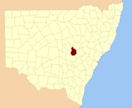 Location in New South Wales | |||||||||||||||
| |||||||||||||||
Gordon County is one of the 141 cadastral divisions of New South Wales. The Macquarie River is the north-eastern boundary.
Gordon County was named in honour of George Hamilton Gordon, Fourth Earl of Aberdeen (1784-1860).[1]
Parishes within this county
A full list of parishes found within this county; their current LGA and mapping coordinates to the approximate centre of each location is as follows:
| Parish | LGA | Coordinates |
|---|---|---|
| Belmore | Cabonne Shire Council | 32°37′54″S 148°25′04″E / 32.63167°S 148.41778°E / -32.63167; 148.41778 (Belmore) |
| Benolong | Dubbo Regional Council | 32°25′54″S 148°39′04″E / 32.43167°S 148.65111°E / -32.43167; 148.65111 (Benolong) |
| Benya | Cabonne Shire Council | 32°57′54″S 148°33′04″E / 32.96500°S 148.55111°E / -32.96500; 148.55111 (Benya) |
| Bolderogery | Cabonne Shire Council | 32°48′54″S 148°36′04″E / 32.81500°S 148.60111°E / -32.81500; 148.60111 (Bolderogery) |
| Buckinbah | Cabonne Shire Council | 32°47′54″S 148°40′04″E / 32.79833°S 148.66778°E / -32.79833; 148.66778 (Buckinbah) |
| Burgoon | Cabonne Shire Council | 32°51′54″S 148°38′04″E / 32.86500°S 148.63444°E / -32.86500; 148.63444 (Burgoon) |
| Burrawong | Cabonne Shire Council | 32°50′54″S 148°44′04″E / 32.84833°S 148.73444°E / -32.84833; 148.73444 (Burrawong) |
| Caloma | Dubbo Regional Council | 32°29′54″S 148°30′04″E / 32.49833°S 148.50111°E / -32.49833; 148.50111 (Caloma) |
| Cardington | Cabonne Shire Council | 32°50′54″S 148°55′04″E / 32.84833°S 148.91778°E / -32.84833; 148.91778 (Cardington) |
| Catombal | Dubbo Regional Council | 32°47′54″S 148°49′04″E / 32.79833°S 148.81778°E / -32.79833; 148.81778 (Catombal) |
| Cullen | Dubbo Regional Council | 32°25′54″S 148°24′04″E / 32.43167°S 148.40111°E / -32.43167; 148.40111 (Cullen) |
| Curra | Dubbo Regional Council | 32°36′54″S 148°54′04″E / 32.61500°S 148.90111°E / -32.61500; 148.90111 (Curra) |
| Dilga | Cabonne Shire Council | 32°56′54″S 148°40′04″E / 32.94833°S 148.66778°E / -32.94833; 148.66778 (Dilga) |
| Draway | Dubbo Regional Council | 32°35′54″S 148°35′04″E / 32.59833°S 148.58444°E / -32.59833; 148.58444 (Draway) |
| Dubbo | Dubbo Regional Council | 32°13′54″S 148°35′04″E / 32.23167°S 148.58444°E / -32.23167; 148.58444 (Dubbo Regional Council) |
| Eurimbula | Cabonne Shire Council | 32°53′54″S 148°49′04″E / 32.89833°S 148.81778°E / -32.89833; 148.81778 (Eurimbula) |
| Ganoo | Dubbo Regional Council | 32°39′54″S 148°41′04″E / 32.66500°S 148.68444°E / -32.66500; 148.68444 (Ganoo) |
| Gilgal | Dubbo Regional Council | 32°31′54″S 148°38′04″E / 32.53167°S 148.63444°E / -32.53167; 148.63444 (Gilgal) |
| Gullengambel | Dubbo Regional Council | 32°36′54″S 148°32′04″E / 32.61500°S 148.53444°E / -32.61500; 148.53444 (Gullengambel) |
| Gundy | Dubbo Regional Council | 32°34′54″S 148°51′04″E / 32.58167°S 148.85111°E / -32.58167; 148.85111 (Gundy) |
| Hyandra | Cabonne Shire Council | 32°52′54″S 148°26′04″E / 32.88167°S 148.43444°E / -32.88167; 148.43444 (Hyandra) |
| Loombah | Dubbo Regional Council | 32°45′54″S 148°44′04″E / 32.76500°S 148.73444°E / -32.76500; 148.73444 (Loombah) |
| Narragal | Dubbo Regional Council | 32°46′54″S 148°57′04″E / 32.78167°S 148.95111°E / -32.78167; 148.95111 (Narragal) |
| Neurea | Dubbo Regional Council | 32°46′54″S 148°53′04″E / 32.78167°S 148.88444°E / -32.78167; 148.88444 (Neurea) |
| Obley | Cabonne Shire Council | 32°44′54″S 148°36′04″E / 32.74833°S 148.60111°E / -32.74833; 148.60111 (Obley) |
| Oxley | Dubbo Regional Council | 32°25′54″S 148°32′04″E / 32.43167°S 148.53444°E / -32.43167; 148.53444 (Oxley) |
| Ponto | Dubbo Regional Council | 32°30′54″S 148°49′04″E / 32.51500°S 148.81778°E / -32.51500; 148.81778 (Ponto) |
| Redbank | Dubbo Regional Council | 32°34′54″S 148°44′04″E / 32.58167°S 148.73444°E / -32.58167; 148.73444 (Redbank) |
| Roche | Dubbo Regional Council | 32°30′54″S 148°33′04″E / 32.51500°S 148.55111°E / -32.51500; 148.55111 (Roche) |
| Rocky Ponds | Cabonne Shire Council | 31°59′54″S 148°30′04″E / 31.99833°S 148.50111°E / -31.99833; 148.50111 (Rocky Ponds) |
| Strathorn | Cabonne Shire Council | 32°44′54″S 148°23′04″E / 32.74833°S 148.38444°E / -32.74833; 148.38444 (Strathorn) |
| Terrabella | Dubbo Regional Council | 32°28′54″S 148°45′04″E / 32.48167°S 148.75111°E / -32.48167; 148.75111 (Terrabella) |
| The Gap | Cabonne Shire Council | 32°56′54″S 148°45′04″E / 32.94833°S 148.75111°E / -32.94833; 148.75111 (The Gap) |
| The Springs | Dubbo Regional Council | 32°29′54″S 148°39′04″E / 32.49833°S 148.65111°E / -32.49833; 148.65111 (The Springs) |
| Veech | Dubbo Regional Council | 32°40′54″S 148°46′04″E / 32.68167°S 148.76778°E / -32.68167; 148.76778 (Veech) |
| Wagstaff | Cabonne Shire Council | 32°46′54″S 148°31′04″E / 32.78167°S 148.51778°E / -32.78167; 148.51778 (Wagstaff) |
| Wandawandong | Cabonne Shire Council | 32°44′54″S 148°32′04″E / 32.74833°S 148.53444°E / -32.74833; 148.53444 (Wandawandong) |
| Warraberry | Cabonne Shire Council | 32°53′54″S 148°33′04″E / 32.89833°S 148.55111°E / -32.89833; 148.55111 (Warraberry) |
| Whylandra | Dubbo Regional Council | 32°20′54″S 148°34′04″E / 32.34833°S 148.56778°E / -32.34833; 148.56778 (Whylandra) |
References
- ^ "Gordon County". Geographical Names Register (GNR) of NSW. Geographical Names Board of New South Wales.


