Goryeong County
County in Yeongnam, South Korea
Goryeong  Flag Emblem of Goryeong | |
|---|---|
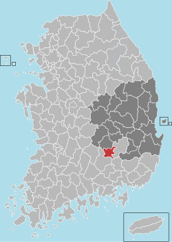 Location in South Korea | |
| Country |  South Korea South Korea |
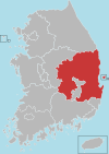
| Region | Yeongnam |
| Administrative divisions | 1 eup, 7 myeon |
| Area | |
| • Total | 383.7 km2 (148.1 sq mi) |
| Population (2004) | |
| • Total | 35,000 |
| • Density | 91.2/km2 (236/sq mi) |
| • Dialect | Gyeongsang |
Goryeong County (Korean: 고령군; RR: Goryeong-gun) is a county in North Gyeongsang Province, South Korea.
Goryeong is a historical center of the ancient kingdom of Daegaya.
Administrative divisions
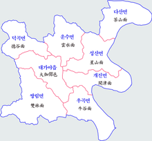
Goryeong County is divided into 1 eup and 7 myeon.
| Name | Hangeul | Hanja |
|---|---|---|
| Daegaya-eup | 대가야읍 | 大伽倻邑 |
| Deokgok-myeon | 덕곡면 | 德谷面 |
| Unsu-myeon | 운수면 | 雲水面 |
| Seongsan-myeon | 성산면 | 星山面 |
| Dasan-myeon | 다산면 | 茶山面 |
| Gaejin-myeon | 개진면 | 開津面 |
| Ugok-myeon | 우곡면 | 牛谷面 |
| Ssangnim-myeon | 쌍림면 | 雙林面 |
Twin towns – sister cities
Goryeong is twinned with:
 Hampyeong, South Korea
- Seocho-gu, South Korea
See also
- Dasan-myeon
- Gaya confederacy
References
External links
- Goryeong County government site Archived 2017-11-20 at the Wayback Machine
35°43′49″N 128°16′08″E / 35.7302777878°N 128.268888899°E / 35.7302777878; 128.268888899
 | This South Korea location article is a stub. You can help Wikipedia by expanding it. |
- v
- t
- e


