Grade II* listed buildings in Ipswich
Map all coordinates using OpenStreetMap
Download coordinates as:
- KML
- GPX (all coordinates)
- GPX (primary coordinates)
- GPX (secondary coordinates)
There are over 20,000 Grade II* listed buildings in England. This page is a list of these buildings in the district of Ipswich in Suffolk.
Ipswich
| Name | Location | Type | Completed [note 1] | Date designated | Grid ref.[note 2] Geo-coordinates | Entry number [note 3] | Image |
|---|---|---|---|---|---|---|---|
| Church of St Clement | Ipswich | Church | 15th century | 19 December 1951 | TM1687344222 52°03′14″N 1°09′42″E / 52.053921°N 1.161773°E / 52.053921; 1.161773 (Church of St Clement) | 1374812 |  More images |
| Church of St Lawrence | Ipswich | Church | 15th century | 19 December 1951 | TM1639144586 52°03′27″N 1°09′18″E / 52.057377°N 1.154984°E / 52.057377; 1.154984 (Church of St Lawrence) | 1206619 |  More images |
| Church of St Mary at the Elms | Ipswich | Church | Late 11th century or early 12th century | 19 December 1951 | TM1606044541 52°03′26″N 1°09′00″E / 52.057102°N 1.150136°E / 52.057102; 1.150136 (Church of St Mary at the Elms) | 1037764 |  More images |
| Church of St Mary at the Quay | Ipswich | Youth Club | 15th century (after 1448) | 19 December 1951 | TM1651444095 52°03′11″N 1°09′23″E / 52.052921°N 1.156465°E / 52.052921; 1.156465 (Church of St Mary at the Quay) | 1037707 |  More images |
| Church of St Mary Le Tower | Ipswich | Church | Medieval | 19 December 1951 | TM1641544695 52°03′30″N 1°09′19″E / 52.058346°N 1.155403°E / 52.058346; 1.155403 (Church of St Mary Le Tower) | 1235800 |  More images |
| Church of St Matthew | Ipswich | Church | 12th century | 19 December 1951 | TM1581444723 52°03′32″N 1°08′48″E / 52.058832°N 1.146668°E / 52.058832; 1.146668 (Church of St Matthew) | 1037690 | 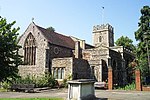 More images |
| Church of St Nicholas | Ipswich | Church | c. 1300 | 19 December 1951 | TM1617344284 52°03′17″N 1°09′06″E / 52.054751°N 1.151619°E / 52.054751; 1.151619 (Church of St Nicholas) | 1187192 | 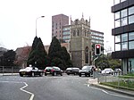 More images |
| Church of St Peter | Ipswich | Church | 14th century | 19 December 1951 | TM1635844118 52°03′11″N 1°09′15″E / 52.053189°N 1.154208°E / 52.053189; 1.154208 (Church of St Peter) | 1037757 | 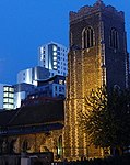 More images |
| Church of St Stephen | Ipswich | Church | 15th century | 19 December 1951 | TM1639844492 52°03′24″N 1°09′18″E / 52.05653°N 1.155027°E / 52.05653; 1.155027 (Church of St Stephen) | 1235373 |  More images |
| Cobbolds on the Quay Public House (Isaacs) | Ipswich | Malt Kiln | Earlier origins | 19 December 1951 | TM1681644096 52°03′10″N 1°09′39″E / 52.052812°N 1.160863°E / 52.052812; 1.160863 (Cobbolds on the Quay Public House (Isaacs)) | 1374793 | 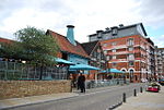 More images |
| Gippeswyk Hall | Ipswich | House | c. 1600 | 19 December 1951 | TM1525843731 52°03′01″N 1°08′17″E / 52.050142°N 1.137946°E / 52.050142; 1.137946 (Gippeswyk Hall) | 1037740 |  More images |
| Great White Horse Hotel | Ipswich | Courtyard | Early 19th century | 19 December 1951 | TM1646244644 52°03′28″N 1°09′22″E / 52.05787°N 1.156055°E / 52.05787; 1.156055 (Great White Horse Hotel) | 1235799 | 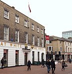 More images |
| 24 St Margaret's Plain | Ipswich | Shop (Blake Mayhew) | C20 | 19 December 1951 | TM1654344794 52°03′33″N 1°09′26″E / 52.059185°N 1.15733°E / 52.059185; 1.15733 (24 St Margaret's Plain) | 1235595 |  More images |
| 35, St Margaret's Street | Ipswich | Shop | Post 17th century | 19 December 1951 | TM1664044707 52°03′30″N 1°09′31″E / 52.058366°N 1.158687°E / 52.058366; 1.158687 (35, St Margaret's Street) | 1235206 |  More images |
| 37 & 39, St Margaret's St (Olde Tudor Cafe) | Ipswich | Shop | C18/C19 | 19 December 1951 | TM1663044712 52°03′30″N 1°09′31″E / 52.058415°N 1.158545°E / 52.058415; 1.158545 (37 & 39, St Margaret's St (Olde Tudor Cafe)) | 1235297 |  More images |
| 56 & 58, St Margaret's St (Blake Mayhew) | Ipswich | Office | C20 | 4 August 1972 | TM1654444791 52°03′33″N 1°09′26″E / 52.059158°N 1.157342°E / 52.059158; 1.157342 (56 & 58, St Margaret's St (Blake Mayhew)) | 1235293 |  More images |
| The Margaret Catchpole Public House | Ipswich | Public House | 1936 | 13 December 1995 | TM1762143280 52°02′43″N 1°10′19″E / 52.045172°N 1.172065°E / 52.045172; 1.172065 (The Margaret Catchpole Public House) | 1243454 |  More images |
| The Old Custom House | Ipswich | Custom House | 1844 | 19 December 1951 | TM1668344092 52°03′10″N 1°09′32″E / 52.052828°N 1.158923°E / 52.052828; 1.158923 (The Old Custom House) | 1374818 | 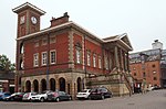 More images |
| Warehouse Attached to West of Warehouse (the Crossway) at Rear of Numbers 80 and 80a Fore Street | Ipswich | Warehouse | 17th century or earlier | 19 December 1951 | TM1680844120 52°03′11″N 1°09′39″E / 52.053031°N 1.160761°E / 52.053031; 1.160761 (Warehouse Attached to West of Warehouse (the Crossway) at Rear of Numbers 80 and 80a Fore Street) | 1096034 | 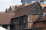 More images |
| Woodside | Ipswich | House | 1872 | 15 December 1977 | TM1594845790 52°04′06″N 1°08′57″E / 52.068358°N 1.149294°E / 52.068358; 1.149294 (Woodside) | 1264602 |  Upload Photo |
| Curson Lodge (45 and 45a St Nicholas Street) | Ipswich | House | 18th century | 4 August 1972 | TM1626144305 52°03′18″N 1°09′10″E / 52.054905°N 1.152913°E / 52.054905; 1.152913 (Curson Lodge (45 and 45a St Nicholas Street)) | 1235464 | 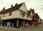 More images |
| Curson Lodge (1 Silent Street, also 47 Nicholas Street) | Ipswich | Cross Wing House | 15th century | 19 December 1951 | TM1626344303 52°03′18″N 1°09′11″E / 52.054886°N 1.152941°E / 52.054886; 1.152941 (Curson Lodge (1 Silent Street, also 47 Nicholas Street)) | 1265084 | More images |
| Curson Lodge (3–9 Silent Street) | Ipswich | Timber Framed Building | 16th century | 19 December 1951 | TM1626644306 52°03′18″N 1°09′11″E / 52.054912°N 1.152987°E / 52.054912; 1.152987 (Curson Lodge (3–9 Silent Street)) | 1235576 |  More images |
| 19 Tower Street | Ipswich | House | 18th century | 19 December 1951 | TM1639744748 52°03′32″N 1°09′19″E / 52.058829°N 1.155174°E / 52.058829; 1.155174 (19 Tower Street) | 1235803 |  More images |
| 24 Fore Street | Ipswich | House | 18th century | 19 December 1951 | TM1669244266 52°03′16″N 1°09′33″E / 52.054387°N 1.159165°E / 52.054387; 1.159165 (24 Fore Street) | 1374792 |  More images |
| 54–58 Fore Street | Ipswich | House/Shops (Steve Tattooist) | Pre Early 19th century | 20 March 1975 | TM1677144185 52°03′13″N 1°09′37″E / 52.053629°N 1.160264°E / 52.053629; 1.160264 (54–58 Fore Street) | 1236157 |  |
| 86 Fore Street | Ipswich | House | 1639 | 19 December 1951 | TM1685544132 52°03′11″N 1°09′41″E / 52.05312°N 1.161453°E / 52.05312; 1.161453 (86 Fore Street) | 1355165 | 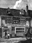 More images |
| 88 Fore Street | Ipswich | Courtyard | C15-C16 | 19 December 1951 | TM1686144129 52°03′11″N 1°09′42″E / 52.053091°N 1.161539°E / 52.053091; 1.161539 (88 Fore Street) | 1374794 |  More images |
Notes
- ^ The date given is the date used by Historic England as significant for the initial building or that of an important part in the structure's description.
- ^ Sometimes known as OSGB36, the grid reference is based on the British national grid reference system used by the Ordnance Survey.
- ^ The "List Entry Number" is a unique number assigned to each listed building and scheduled monument by Historic England.
External links
- v
- t
- e
- Bedfordshire
- Berkshire
- Bristol
- Buckinghamshire
- Cambridgeshire
- Cheshire
- Cornwall
- Cumbria
- Derbyshire
- Devon
- Dorset
- Durham
- East Sussex
- East Riding of Yorkshire
- Essex
- Gloucestershire
- Greater London
- Greater Manchester
- Hampshire
- Herefordshire
- Hertfordshire
- Isle of Wight
- Kent
- Lancashire
- Leicestershire
- Lincolnshire
- Merseyside
- Norfolk
- North Yorkshire
- Northamptonshire
- Northumberland
- Nottinghamshire
- Oxfordshire
- Rutland
- Shropshire
- Somerset
- South Yorkshire
- Staffordshire
- Suffolk
- Surrey
- Tyne and Wear
- Warwickshire
- West Midlands
- West Sussex
- West Yorkshire
- Wiltshire
- Worcestershire
- Allerdale
- Amber Valley
- Ashford
- Babergh
- Barrow-in-Furness
- Basildon
- Basingstoke and Deane
- Bath and North East Somerset
- Bolsover
- Boston
- Bournemouth
- Bradford
- Braintree
- Breckland
- Brentwood
- Brighton and Hove
- Bristol
- Broadland
- Calderdale
- Cambridge
- Camden
- Canterbury
- Carlisle
- Castle Point
- Chelmsford
- Cheltenham
- Cherwell
- Cheshire East
- Cheshire West and Chester
- Chesterfield
- Chiltern
- Christchurch
- Colchester
- Copeland
- Corby
- Cotswold
- Dartford
- Daventry
- Dover
- East Cambridgeshire
- Exeter
- Mendip
- North Somerset
- North Yorkshire (district)
- Poole
- Sedgemoor
- South Somerset
- Stoke-on-Trent
- Taunton Deane
- West Somerset
- York


