Grade II* listed buildings in Rother

Map all coordinates using OpenStreetMap
Download coordinates as:
- KML
- GPX (all coordinates)
- GPX (primary coordinates)
- GPX (secondary coordinates)
There are over 20,000 Grade II* listed buildings in England. This page is a list of these buildings in the district of Rother in East Sussex.
Rother
| Name | Location | Type | Completed [note 1] | Date designated | Grid ref.[note 2] Geo-coordinates | Entry number [note 3] | Image |
|---|---|---|---|---|---|---|---|
| Court Lodge Farmhouse | Court Lodge, Ashburnham, Rother | Farmhouse | Early 17th century | 3 August 1961 | TQ6822016383 50°55′21″N 0°23′31″E / 50.922384°N 0.392044°E / 50.922384; 0.392044 (Court Lodge Farmhouse) | 1352831 |  Upload Photo |
| The former stables at Ashburnham Place | Ashburnham Place, Ashburnham, Rother | Stable | Early 18th century | 3 August 1961 | TQ6892014524 50°54′20″N 0°24′04″E / 50.905477°N 0.401134°E / 50.905477; 0.401134 (The former stables at Ashburnham Place) | 1278909 |  |
| Church of St John | Netherfield, Battle, Rother | Church | 1859 | 13 May 1987 | TQ7231918526 50°56′26″N 0°27′05″E / 50.940428°N 0.45132°E / 50.940428; 0.45132 (Church of St John) | 1278194 |  More images |
| Lewins Croft | Battle, Rother | House | Post 16th century | 3 August 1961 | TQ7475916194 50°55′07″N 0°29′06″E / 50.918744°N 0.484898°E / 50.918744; 0.484898 (Lewins Croft) | 1044164 | Upload Photo |
| Priory House Hotel | Battle, Rother | House | 1700 | 3 August 1961 | TQ7476715910 50°54′58″N 0°29′06″E / 50.91619°N 0.484876°E / 50.91619; 0.484876 (Priory House Hotel) | 1044216 | Upload Photo |
| The Almonry | Battle, Rother | House | 16th century | 3 August 1961 | TQ7464916078 50°55′04″N 0°29′00″E / 50.917735°N 0.483279°E / 50.917735; 0.483279 (The Almonry) | 1044222 |  More images |
| The Deanery including the Former Stables | Battle, Rother | Deanery | 16th century | 3 August 1961 | TQ7502415850 50°54′56″N 0°29′19″E / 50.915573°N 0.4885°E / 50.915573; 0.4885 (The Deanery including the Former Stables) | 1352882 | 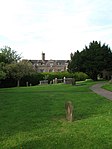 |
| The Pilgrims Rest Restaurant | Battle, Rother | Guest House | 15th century | 3 August 1961 | TQ7480615794 50°54′54″N 0°29′07″E / 50.915136°N 0.485375°E / 50.915136; 0.485375 (The Pilgrims Rest Restaurant) | 1230278 | 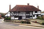 More images |
| No. 18 High Street | Battle, Rother | House | 18th century | 3 August 1961 | TQ7475615924 50°54′59″N 0°29′05″E / 50.916319°N 0.484726°E / 50.916319; 0.484726 (No. 18 High Street) | 1044217 | Upload Photo |
| Knelle Dower Farmhouse | Beckley, Rother | Farmhouse | 15th century | 3 August 1961 | TQ8387723680 50°58′59″N 0°37′06″E / 50.983159°N 0.618255°E / 50.983159; 0.618255 (Knelle Dower Farmhouse) | 1277352 | Upload Photo |
| Parish Church of St Giles | Bodiam, Rother | Parish Church | Early 14th century | 3 August 1961 | TQ7823726191 51°00′27″N 0°32′21″E / 51.007489°N 0.539221°E / 51.007489; 0.539221 (Parish Church of St Giles) | 1352896 | 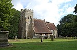 More images |
| Brede Place | Brede, Rother | House | Pre 15th century | 3 August 1961 | TQ8363918324 50°56′06″N 0°36′44″E / 50.935123°N 0.612168°E / 50.935123; 0.612168 (Brede Place) | 1044120 | 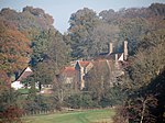 More images |
| Reysons Farmhouse | Reysons Farm, Brede, Rother | Farmhouse | Medieval | 13 May 1987 | TQ8323719576 50°56′47″N 0°36′25″E / 50.946497°N 0.607082°E / 50.946497; 0.607082 (Reysons Farmhouse) | 1044107 | Upload Photo |
| Brightling Needle | Brightling, Rother | Obelisk | Early 19th century | 3 August 1961 | TQ6700721209 50°57′58″N 0°22′37″E / 50.966096°N 0.377013°E / 50.966096; 0.377013 (Brightling Needle) | 1044089 |  More images |
| Brightling Park | Brightling, Rother | House | Early 18th century | 14 September 1954 | TQ6833720933 50°57′48″N 0°23′45″E / 50.963229°N 0.395808°E / 50.963229; 0.395808 (Brightling Park) | 1352916 |  More images |
| The Mausoleum of John Fuller in the Churchyard | Brightling, Rother | Mausoleum | 1810 | 3 August 1961 | TQ6837720980 50°57′49″N 0°23′47″E / 50.96364°N 0.396399°E / 50.96364; 0.396399 (The Mausoleum of John Fuller in the Churchyard) | 1232442 |  More images |
| The Observatory | Brightling, Rother | Observatory/House | Early 19th century | 3 August 1961 | TQ6706920748 50°57′43″N 0°22′40″E / 50.961936°N 0.377683°E / 50.961936; 0.377683 (The Observatory) | 1277117 |  More images |
| The Summerhouse or Alcove at Brightling Park to the west of the house | Brightling Park, Brightling, Rother | Summerhouse | Early 19th century | 3 August 1961 | TQ6774120760 50°57′43″N 0°23′14″E / 50.961849°N 0.387249°E / 50.961849; 0.387249 (The Summerhouse or Alcove at Brightling Park to the west of the house) | 1044062 | Upload Photo |
| The Temple at Brightling Park to the south west of the house | Brightling Park, Brightling, Rother | Folly | Early 19th century | 3 August 1961 | TQ6803220326 50°57′28″N 0°23′28″E / 50.957865°N 0.391189°E / 50.957865; 0.391189 (The Temple at Brightling Park to the south west of the house) | 1352934 |  More images |
| Burghurst | Burwash, Rother | House | 18th century | 3 August 1961 | TQ6763824778 50°59′53″N 0°23′15″E / 50.997978°N 0.387635°E / 50.997978; 0.387635 (Burghurst) | 1044051 | Upload Photo |
| Chateaubriand, Premises occupied by E Watson and Sons, E Workman Greengrocers and Villiers, High St | Burwash, Rother | House | 18th century | 3 August 1961 | TQ6744324723 50°59′51″N 0°23′05″E / 50.997541°N 0.384834°E / 50.997541; 0.384834 (Chateaubriand, Premises occupied by E Watson and Sons, E Workman Greengrocers and Villiers, High St) | 1232850 | 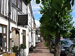 |
| Glebe House | Burwash, Rother | House | 1961 | 3 August 1961 | TQ6823024997 50°59′59″N 0°23′46″E / 50.999773°N 0.396166°E / 50.999773; 0.396166 (Glebe House) | 1232557 | Upload Photo |
| The Old House | Burwash, Rother | House | Later-Post 15th century | 3 August 1961 | TQ6768924693 50°59′50″N 0°23′18″E / 50.9972°N 0.388322°E / 50.9972; 0.388322 (The Old House) | 1276843 | Upload Photo |
| Parish Church of St Laurence | Catsfield, Rother | Parish Church | Early 12th century | 3 August 1961 | TQ7285513363 50°53′38″N 0°27′23″E / 50.893883°N 0.456497°E / 50.893883; 0.456497 (Parish Church of St Laurence) | 1233163 | 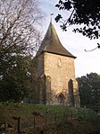 More images |
| Hye House | Crowhurst, Rother | House | 1744 | 3 August 1961 | TQ7563611725 50°52′42″N 0°29′43″E / 50.878329°N 0.495215°E / 50.878329; 0.495215 (Hye House) | 1233348 | Upload Photo |
| The Old Manor House | Dallington, Rother | Wealden House | 15th century | 3 August 1961 | TQ6572619030 50°56′49″N 0°21′28″E / 50.946888°N 0.357795°E / 50.946888; 0.357795 (The Old Manor House) | 1233383 |  |
| The Parish Church of St Giles | Dallington, Rother | Parish Church | Early 16th century | 3 August 1961 | TQ6578119059 50°56′50″N 0°21′31″E / 50.947132°N 0.35859°E / 50.947132; 0.35859 (The Parish Church of St Giles) | 1233384 |  More images |
| The Sugarloaf | The Sugarloaf, Dallington, Rother | Obelisk | Early 19th century | 3 August 1961 | TQ6692119550 50°57′04″N 0°22′30″E / 50.951215°N 0.375029°E / 50.951215; 0.375029 (The Sugarloaf) | 1233371 | 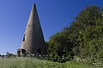 More images |
| The Parish Church of St Mary | East Guldeford, Rother | Church | 1499-1505 | 3 August 1961 | TQ9368821563 50°57′39″N 0°45′24″E / 50.96093°N 0.756733°E / 50.96093; 0.756733 (The Parish Church of St Mary) | 1276544 |  More images |
| Great Maxfield | Guestling, Rother | Jettied House | 15th century | 3 August 1961 | TQ8339315222 50°54′26″N 0°36′26″E / 50.907335°N 0.607112°E / 50.907335; 0.607112 (Great Maxfield) | 1365297 | Upload Photo |
| Iridge Place | Hurst Green, Rother | House | 18th century | 3 August 1961 | TQ7377726953 51°00′57″N 0°28′34″E / 51.015698°N 0.476077°E / 51.015698; 0.476077 (Iridge Place) | 1365292 | 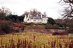 More images |
| Periteau House, including the cellar under the garden | Winchelsea, Icklesham, Rother | House | 18th century | 3 August 1961 | TQ9055517418 50°55′29″N 0°42′36″E / 50.924743°N 0.710007°E / 50.924743; 0.710007 (Periteau House, including the cellar under the garden) | 1234400 | 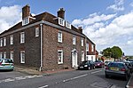 More images |
| Strand Platt, Rookery Lane | Winchelsea, Icklesham, Rother | House | 18th century | 3 August 1961 | TQ9062417380 50°55′28″N 0°42′39″E / 50.924379°N 0.710968°E / 50.924379; 0.710968 (Strand Platt, Rookery Lane) | 1275964 | Upload Photo |
| The Armoury | Winchelsea, Icklesham, Rother | House | Medieval | 3 August 1961 | TQ9056117459 50°55′30″N 0°42′36″E / 50.925109°N 0.710114°E / 50.925109; 0.710114 (The Armoury) | 1234432 |  More images |
| The Five Houses, Nos 4 & 5, Higham Green | Winchelsea, Icklesham, Rother | House | 17th century | 3 August 1961 | TQ9046717579 50°55′34″N 0°42′32″E / 50.926218°N 0.70884°E / 50.926218; 0.70884 (The Five Houses, Nos 4 & 5, Higham Green) | 1234608 |  |
| The Five Houses, Nos 1-3, North St | Winchelsea, Icklesham, Rother | House | 17th century | 3 August 1961 | TQ9047217588 50°55′35″N 0°42′32″E / 50.926297°N 0.708916°E / 50.926297; 0.708916 (The Five Houses, Nos 1-3, North St) | 1234560 | |
| Wickham Manor House | Winchelsea, Icklesham, Rother | House | Early 16th century | 3 August 1961 | TQ8983616489 50°55′00″N 0°41′57″E / 50.916635°N 0.699305°E / 50.916635; 0.699305 (Wickham Manor House) | 1234746 |  More images |
| No. 1-10 Barrack Square | Winchelsea, Icklesham, Rother | House | 18th century | 3 August 1961 | TQ9063817478 50°55′31″N 0°42′40″E / 50.925254°N 0.711218°E / 50.925254; 0.711218 (No. 1-10 Barrack Square) | 1234386 | Upload Photo |
| Oxenbridge Farmhouse | Iden, Rother | Farmhouse | Early 15th century | 3 August 1961 | TQ9165824567 50°59′19″N 0°43′46″E / 50.988591°N 0.729444°E / 50.988591; 0.729444 (Oxenbridge Farmhouse) | 1234970 | 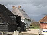 More images |
| Mountfield Court | Mountfield, Rother | House | Late 17th century or Early 18th century | 3 August 1961 | TQ7358520854 50°57′39″N 0°28′14″E / 50.960963°N 0.470431°E / 50.960963; 0.470431 (Mountfield Court) | 1234935 |  More images |
| Parish Church of All Saints | Mountfield, Rother | Parish Church | Early 12th century | 3 August 1961 | TQ7347320276 50°57′21″N 0°28′07″E / 50.955804°N 0.468562°E / 50.955804; 0.468562 (Parish Church of All Saints) | 1275863 |  More images |
| Church House | Northiam | House | Late 18th century or Early 19th century | 3 August 1961 | TQ8306224552 50°59′29″N 0°36′26″E / 50.991252°N 0.607096°E / 50.991252; 0.607096 (Church House) | 1235021 |  |
| Newenden Bridge | Northiam | Bridge | 1706 | 3 August 1961 | TQ8352127039 51°00′48″N 0°36′54″E / 51.013446°N 0.614885°E / 51.013446; 0.614885 (Newenden Bridge) | 1217121 | 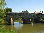 More images |
| Oakside | Northiam | House | 18th century | 3 August 1961 | TQ8294424475 50°59′26″N 0°36′19″E / 50.990598°N 0.605378°E / 50.990598; 0.605378 (Oakside) | 1216981 | 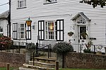 |
| Oasthouses and Barn at Great Dixter to the North West of the House | Northiam | Oasthouse | Oasthouse 18th century, barn 15th century | 20 May 1976 | TQ8195725164 50°59′50″N 0°35′30″E / 50.9971°N 0.591674°E / 50.9971; 0.591674 (Oasthouses and Barn at Great Dixter to the North West of the House) | 1216899 | 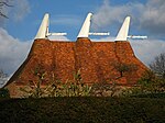 |
| Strawberry Hole | Strawberry Hole, Northiam, Rother | House | Later-Post 15th century | 3 August 1961 | TQ8208724143 50°59′16″N 0°35′35″E / 50.987887°N 0.593014°E / 50.987887; 0.593014 (Strawberry Hole) | 1235029 | 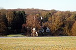 |
| The Parish Church of St Mary (including the Frewen Mausoleum) | Northiam, Rother | Parish Church | Norman | 3 August 1961 | TQ8300824517 50°59′27″N 0°36′23″E / 50.990955°N 0.60631°E / 50.990955; 0.60631 (The Parish Church of St Mary (including the Frewen Mausoleum)) | 1275827 |  More images |
| Flackley Ash Hotel | Flackley Ash, Peasmarsh, Rother | House | 18th century | 3 August 1961 | TQ8804123310 50°58′43″N 0°40′38″E / 50.978492°N 0.677318°E / 50.978492; 0.677318 (Flackley Ash Hotel) | 1275455 | 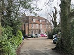 More images |
| Woodside | Peasmarsh, Rother | House | c. 1790 | 3 August 1961 | TQ8853123097 50°58′35″N 0°41′03″E / 50.976419°N 0.68418°E / 50.976419; 0.68418 (Woodside) | 1217327 | Upload Photo |
| Church Farmhouse | Church Farm, Penhurst, Rother | Farmhouse | Early 17th century | 3 August 1961 | TQ6944016509 50°55′23″N 0°24′34″E / 50.923159°N 0.409444°E / 50.923159; 0.409444 (Church Farmhouse) | 1217564 | Upload Photo |
| Bank Chambers (the Justices' Clerk's Offices) | Rye, Rother | Legal Chambers | 18th century | 12 October 1951 | TQ9199820348 50°57′02″N 0°43′55″E / 50.950582°N 0.732057°E / 50.950582; 0.732057 (Bank Chambers (the Justices' Clerk's Offices)) | 1251665 | Upload Photo |
| Cobble Cottage, 18, West St | Rye, Rother | House | Refaced early 19th century | 12 October 1951 | TQ9202020324 50°57′01″N 0°43′56″E / 50.950359°N 0.732357°E / 50.950359; 0.732357 (Cobble Cottage, 18, West St) | 1252157 | Upload Photo |
| Flushing Inn & 3, Monks Way | Rye, Rother | House | 16th century | 12 October 1951 | TQ9218020347 50°57′02″N 0°44′05″E / 50.950513°N 0.734644°E / 50.950513; 0.734644 (Flushing Inn & 3, Monks Way) | 1251880 |  More images |
| Hartshorn House 31, Mermaid St | Rye, Rother | House | 16th century | 12 October 1951 | TQ9195620280 50°57′00″N 0°43′53″E / 50.949986°N 0.731424°E / 50.949986; 0.731424 (Hartshorn House 31, Mermaid St) | 1251959 | 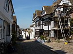 More images |
| Lamb House | Rye, Rother | House | Beginning of the 18th century | 12 October 1951 | TQ9204820272 50°57′00″N 0°43′58″E / 50.949883°N 0.732728°E / 50.949883; 0.732728 (Lamb House) | 1252151 |  More images |
| The Mermaid Inn | Rye, Rother | House | 18th century | 12 October 1951 | TQ9200820293 50°57′00″N 0°43′56″E / 50.950085°N 0.73217°E / 50.950085; 0.73217 (The Mermaid Inn) | 1251961 | 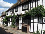 More images |
| St Anthony of Padua (house in Church Square, Rye) | Rye, Rother | Jettied House | 15th century | 12 October 1951 | TQ9210520247 50°56′59″N 0°44′01″E / 50.949639°N 0.733525°E / 50.949639; 0.733525 (St Anthony of Padua (house in Church Square, Rye)) | 1262779 | 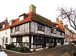 More images |
| The Town Hall | Rye, Rother | Town Hall | 1831 | 12 October 1951 | TQ9215120332 50°57′01″N 0°44′03″E / 50.950388°N 0.734224°E / 50.950388; 0.734224 (The Town Hall) | 1251881 | 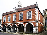 More images |
| The Water Tower (standing in the North East Corner of the Churchyard) | Rye, Rother | Water Tower | 1733-1735 | 12 October 1951 | TQ9217620322 50°57′01″N 0°44′04″E / 50.95029°N 0.734574°E / 50.95029; 0.734574 (The Water Tower (standing in the North East Corner of the Churchyard)) | 1044326 | 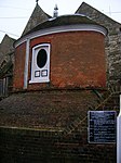 More images |
| No. 1 East Street and 104 and 104A High Street | Rye, Rother | House | Late 18th century or early 19th century | 12 October 1951 | TQ9215320426 50°57′04″N 0°44′03″E / 50.951231°N 0.734302°E / 50.951231; 0.734302 (No. 1 East Street and 104 and 104A High Street) | 1251729 | Upload Photo |
| Cordbatt Cottage | Lea Farm, Rye Foreign, Rother | House | Early 19th century | 13 May 1987 | TQ9010422553 50°58′16″N 0°42′23″E / 50.971015°N 0.706276°E / 50.971015; 0.706276 (Cordbatt Cottage) | 1275286 |  |
| Robertsbridge Abbey | Robertsbridge, Salehurst and Robertsbridge, Rother | Abbey ruins | 1176 | 3 August 1961 | TQ7546123825 50°59′14″N 0°29′55″E / 50.987086°N 0.49855°E / 50.987086; 0.49855 (Robertsbridge Abbey) | 1274121 | 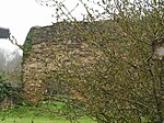 More images |
| Great Wigsell | Bodiam, Salehurst and Robertsbridge, Rother | House | Early 17th century | 3 August 1961 | TQ7607227352 51°01′07″N 0°30′32″E / 51.018585°N 0.508956°E / 51.018585; 0.508956 (Great Wigsell) | 1221404 | 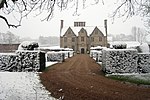 More images |
| Monk's Cottage | Robertsbridge, Salehurst and Robertsbridge, Rother | House | 16th century | 3 August 1961 | TQ7387024117 50°59′25″N 0°28′34″E / 50.990192°N 0.476044°E / 50.990192; 0.476044 (Monk's Cottage) | 1221521 | 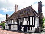 More images |
| Rosebank | Robertsbridge, Salehurst and Robertsbridge, Rother | House | 16th century | 3 August 1961 | TQ7382023727 50°59′12″N 0°28′31″E / 50.986703°N 0.475146°E / 50.986703; 0.475146 (Rosebank) | 1221397 | 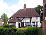 More images |
| The Seven Stars Inn (Seven Sisters) | Robertsbridge, Salehurst and Robertsbridge, Rother | Wealden House | 14th century | 3 August 1961 | TQ7378923622 50°59′09″N 0°28′29″E / 50.985769°N 0.474655°E / 50.985769; 0.474655 (The Seven Stars Inn (Seven Sisters)) | 1275146 | 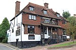 More images |
| Durhamford Manor | Sedlescombe, Rother | Jettied House | Early 16th century | 3 August 1961 | TQ7728418852 50°56′31″N 0°31′19″E / 50.941853°N 0.522076°E / 50.941853; 0.522076 (Durhamford Manor) | 1222027 |  More images |
| The Parish Church of St John the Baptist | Sedlescombe, Rother | Parish Church | Early 15th century | 3 August 1961 | TQ7771218803 50°56′29″N 0°31′41″E / 50.941281°N 0.528138°E / 50.941281; 0.528138 (The Parish Church of St John the Baptist) | 1275087 | 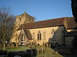 More images |
| Courthorpes & Whiligh | Ticehurst, Rother | House | 1586 | 3 August 1961 | TQ6566531255 51°03′24″N 0°21′45″E / 51.056742°N 0.362502°E / 51.056742; 0.362502 (Courthorpes & Whiligh) | 1237733 | 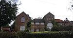 |
| Dunsters Mill House | Three Leg Cross, Ticehurst, Rother | House | Later-Post 15th century | 3 August 1961 | TQ6896231991 51°03′45″N 0°24′35″E / 51.062394°N 0.409846°E / 51.062394; 0.409846 (Dunsters Mill House) | 1222585 | Upload Photo |
| The Parish Church of St Mary | Ticehurst, Rother | Parish Church | Medieval | 3 August 1961 | TQ6887930101 51°02′44″N 0°24′28″E / 51.045439°N 0.407781°E / 51.045439; 0.407781 (The Parish Church of St Mary) | 1222324 | 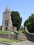 More images |
| Wardsbrook Farmhouse | Ticehurst, Rother | Farmhouse | 16th century | 3 August 1961 | TQ6872429102 51°02′11″N 0°24′18″E / 51.036509°N 0.405107°E / 51.036509; 0.405107 (Wardsbrook Farmhouse) | 1237751 | Upload Photo |
| Knellstone | Udimore, Rother | House | 15th century | 3 August 1961 | TQ8791718710 50°56′14″N 0°40′23″E / 50.937213°N 0.673181°E / 50.937213; 0.673181 (Knellstone) | 1237763 | Upload Photo |
| The Hammonds | Udimore, Rother | Farmhouse | Late 17th century | 3 August 1961 | TQ8848219341 50°56′34″N 0°40′54″E / 50.942697°N 0.681539°E / 50.942697; 0.681539 (The Hammonds) | 1238077 | Upload Photo |
| The Parish Church of St Mary Magdalen | Whatlington, Rother | Parish Church | 13th century | 3 August 1961 | TQ7605618225 50°56′12″N 0°30′16″E / 50.936596°N 0.504312°E / 50.936596; 0.504312 (The Parish Church of St Mary Magdalen) | 1238301 | 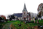 More images |
| Parish Church of St Peter | Bexhill-on-Sea | Church | Late 11th century or early 12th century | 11 May 1949 | TQ7460708096 50°50′46″N 0°28′44″E / 50.846038°N 0.478872°E / 50.846038; 0.478872 (Parish Church of St Peter) | 1352817 | 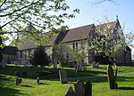 More images |
| Burwash War Memorial | Burwash | War memorial | 1920 | 25 August 1998 | TQ6765424754 50°59′52″N 0°23′16″E / 50.997758°N 0.38785219°E / 50.997758; 0.38785219 (Burwash War Memorial) | 1376156 | 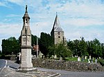 More images |
Notes
- ^ The date given is the date used by Historic England as significant for the initial building or that of an important part in the structure's description.
- ^ Sometimes known as OSGB36, the grid reference is based on the British national grid reference system used by the Ordnance Survey.
- ^ The "List Entry Number" is a unique number assigned to each listed building and scheduled monument by Historic England.
External links
- v
- t
- e
- Bedfordshire
- Berkshire
- Bristol
- Buckinghamshire
- Cambridgeshire
- Cheshire
- Cornwall
- Cumbria
- Derbyshire
- Devon
- Dorset
- Durham
- East Sussex
- East Riding of Yorkshire
- Essex
- Gloucestershire
- Greater London
- Greater Manchester
- Hampshire
- Herefordshire
- Hertfordshire
- Isle of Wight
- Kent
- Lancashire
- Leicestershire
- Lincolnshire
- Merseyside
- Norfolk
- North Yorkshire
- Northamptonshire
- Northumberland
- Nottinghamshire
- Oxfordshire
- Rutland
- Shropshire
- Somerset
- South Yorkshire
- Staffordshire
- Suffolk
- Surrey
- Tyne and Wear
- Warwickshire
- West Midlands
- West Sussex
- West Yorkshire
- Wiltshire
- Worcestershire
- Allerdale
- Amber Valley
- Ashford
- Babergh
- Barrow-in-Furness
- Basildon
- Basingstoke and Deane
- Bath and North East Somerset
- Bolsover
- Boston
- Bournemouth
- Bradford
- Braintree
- Breckland
- Brentwood
- Brighton and Hove
- Bristol
- Broadland
- Calderdale
- Cambridge
- Camden
- Canterbury
- Carlisle
- Castle Point
- Chelmsford
- Cheltenham
- Cherwell
- Cheshire East
- Cheshire West and Chester
- Chesterfield
- Chiltern
- Christchurch
- Colchester
- Copeland
- Corby
- Cotswold
- Dartford
- Daventry
- Dover
- East Cambridgeshire
- Exeter
- Mendip
- North Somerset
- North Yorkshire (district)
- Poole
- Sedgemoor
- South Somerset
- Stoke-on-Trent
- Taunton Deane
- West Somerset
- York


