Grade II* listed buildings in South Northamptonshire
Map all coordinates using OpenStreetMap
Download coordinates as:
- KML
- GPX (all coordinates)
- GPX (primary coordinates)
- GPX (secondary coordinates)
There are more than 20,000 Grade II* listed buildings in England. This page is a list of these buildings in the district of South Northamptonshire in Northamptonshire.
South Northamptonshire
| Name | Location | Type | Completed [note 1] | Date designated | Grid ref.[note 2] Geo-coordinates | Entry number [note 3] | Image |
|---|---|---|---|---|---|---|---|
| Adstone House and attached Garden Wall | Adstone, South Northamptonshire | House | Mid to late 17th century | 1 December 1951 | SP5942851530 52°09′32″N 1°07′58″W / 52.158855°N 1.132696°W / 52.158855; -1.132696 (Adstone House and attached Garden Wall) | 1040930 |  Upload Photo |
| Church of St Margaret | Alderton | Church | Late Perpendicular | 17 May 1960 | SP7404746909 52°06′56″N 0°55′12″W / 52.115554°N 0.920037°W / 52.115554; -0.920037 (Church of St Margaret) | 1190752 |  More images |
| Church of St Michael and All Angels | Ashton | Church | 14th century | 3 May 1968 | SP7652449977 52°08′34″N 0°52′59″W / 52.142794°N 0.883181°W / 52.142794; -0.883181 (Church of St Michael and All Angels) | 1190600 |  More images |
| 6 Round Town | Aynho | House | Late 15th century | 4 February 1969 | SP5141133170 51°59′41″N 1°15′09″W / 51.994606°N 1.252637°W / 51.994606; -1.252637 (6 Round Town) | 1192400 |  |
| Church of St Mary | Blakesley | Church | c. 1300 | 17 May 1960 | SP6270550471 52°08′56″N 1°05′06″W / 52.148974°N 1.084994°W / 52.148974; -1.084994 (Church of St Mary) | 1371622 |  More images |
| Priory Farmhouse | Blakesley | Farmhouse | 15th century | 1 December 1951 | SP6265350454 52°08′56″N 1°05′09″W / 52.148827°N 1.085757°W / 52.148827; -1.085757 (Priory Farmhouse) | 1040897 | Upload Photo |
| Church of St John the Baptist | Blisworth | Church | 13th century | 17 May 1960 | SP7252953410 52°10′27″N 0°56′27″W / 52.174192°N 0.940816°W / 52.174192; -0.940816 (Church of St John the Baptist) | 1371587 |  More images |
| Stoneacre | Blisworth | House | Early-mid 17th century | 1 December 1951 | SP7278753579 52°10′32″N 0°56′13″W / 52.175677°N 0.937008°W / 52.175677; -0.937008 (Stoneacre) | 1189162 | 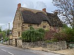 |
| Brackley Lodge (including Gate Piers) | Brackley | House | Early 18th century | 22 April 1950 | SP5852737018 52°01′43″N 1°08′54″W / 52.028495°N 1.148352°W / 52.028495; -1.148352 (Brackley Lodge (including Gate Piers)) | 1189911 |  More images |
| Magdalen College Chapel of Saints John and James | Brackley | School chapel | 12th century | 22 April 1950 | SP5859837003 52°01′42″N 1°08′50″W / 52.028353°N 1.14732°W / 52.028353; -1.14732 (Magdalen College Chapel of Saints John and James) | 1040573 |  More images |
| Town Hall | Brackley | Town Hall | 1705-6 | 22 April 1950 | SP5843536809 52°01′36″N 1°08′59″W / 52.026626°N 1.149729°W / 52.026626; -1.149729 (Town Hall) | 1190100 |  More images |
| 82–88 High Street | Brackley | Almshouse | 1633 | 22 April 1950 | SP5881437473 52°01′57″N 1°08′39″W / 52.032555°N 1.144091°W / 52.032555; -1.144091 (82–88 High Street) | 1371804 | Upload Photo |
| Church of St Michael | Bradden | Church | 13th century | 14 December 1987 | SP6473748522 52°07′52″N 1°03′20″W / 52.13122°N 1.055672°W / 52.13122; -1.055672 (Church of St Michael) | 1294406 |  More images |
| Church of St Lawrence | Brafield on the Green | Church | 12th century | 3 May 1968 | SP8221559060 52°13′25″N 0°47′52″W / 52.22362°N 0.797839°W / 52.22362; -0.797839 (Church of St Lawrence) | 1041597 | 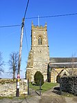 More images |
| Church of St Michael and All Angels | Bugbrooke | Parish Church | C13-C15 | 3 May 1968 | SP6740057311 52°12′36″N 1°00′54″W / 52.209907°N 1.015031°W / 52.209907; -1.015031 (Church of St Michael and All Angels) | 1041055 |  More images |
| The Dower House | Bugbrooke | House | Late 17th century | 3 May 1968 | SP6776157078 52°12′28″N 1°00′35″W / 52.207769°N 1.009795°W / 52.207769; -1.009795 (The Dower House) | 1190311 | Upload Photo |
| Terrace Gardens | Castle Ashby Park, Castle Ashby | Gate | 1864 | 6 September 1988 | SP8639459225 52°13′28″N 0°44′12″W / 52.224464°N 0.736634°W / 52.224464; -0.736634 (Terrace Gardens) | 1189676 | Upload Photo |
| The Menagerie | Castle Ashby Park, Castle Ashby | House | 1761–74 | 3 May 1968 | SP8683059378 52°13′33″N 0°43′49″W / 52.225771°N 0.730214°W / 52.225771; -0.730214 (The Menagerie) | 1189885 | Upload Photo |
| Chacombe Priory | Chacombe | Country House | 16th century | 11 September 1953 | SP4885143887 52°05′28″N 1°17′18″W / 52.091181°N 1.288391°W / 52.091181; -1.288391 (Chacombe Priory) | 1041228 | 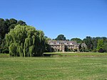 More images |
| The Manor House | Chipping Warden and Edgcote | Manor House | 16th century | 4 February 1969 | SP4995748779 52°08′06″N 1°16′18″W / 52.135061°N 1.271534°W / 52.135061; -1.271534 (The Manor House) | 1293906 | Upload Photo |
| Church of St Peter | Cogenhoe, Cogenhoe and Whiston | Church | 13th century | 3 May 1968 | SP8301961045 52°14′29″N 0°47′08″W / 52.241341°N 0.785585°W / 52.241341; -0.785585 (Church of St Peter) | 1041575 | 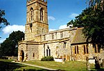 More images |
| Church of St Luke | Cold Higham | Parish Church | 13th century | 17 May 1960 | SP6627053513 52°10′33″N 1°01′56″W / 52.175903°N 1.032307°W / 52.175903; -1.032307 (Church of St Luke) | 1190319 |  More images |
| Bridge Number 65 | Grand Union Canal, Cosgrove | Canal Bridge | c. 1800 | 1 December 1951 | SP7928942742 52°04′39″N 0°50′40″W / 52.077372°N 0.844467°W / 52.077372; -0.844467 (Bridge Number 65) | 1190608 |  More images |
| Church of St Peter and St Paul | Courteenhall | Church | C13-C17 | 3 May 1968 | SP7644952928 52°10′10″N 0°53′01″W / 52.169331°N 0.883613°W / 52.169331; -0.883613 (Church of St Peter and St Paul) | 1040983 | 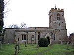 More images |
| Courteenhall House and attached Offices | Courteenhall | Country House | 1791-3 | 23 August 1955 | SP7614053132 52°10′16″N 0°53′17″W / 52.171207°N 0.888085°W / 52.171207; -0.888085 (Courteenhall House and attached Offices) | 1189193 |  More images |
| Courteenhall House Stable Block and attached Coach Houses, Stables and Barn | Courteenhall | Stables | Mid 18th century | 23 August 1955 | SP7609652966 52°10′11″N 0°53′20″W / 52.169721°N 0.888765°W / 52.169721; -0.888765 (Courteenhall House Stable Block and attached Coach Houses, Stables and Barn) | 1371591 | Upload Photo |
| The School and School House | Courteenhall | House | C20 | 3 May 1968 | SP7590353130 52°10′16″N 0°53′30″W / 52.171222°N 0.89155°W / 52.171222; -0.89155 (The School and School House) | 1040984 | Upload Photo |
| Church of St Mary | Culworth | Church | Early 13th century | 4 February 1969 | SP5443546940 52°07′05″N 1°12′23″W / 52.118107°N 1.206409°W / 52.118107; -1.206409 (Church of St Mary) | 1189875 | 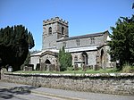 More images |
| Wall, Gatepiers and Gateway about 20m south of Church of St Mary | Culworth | Gate | C18/C19 | 4 July 1985 | SP5443646919 52°07′05″N 1°12′23″W / 52.117918°N 1.206398°W / 52.117918; -1.206398 (Wall, Gatepiers and Gateway about 20m south of Church of St Mary) | 1040493 | Upload Photo |
| Church of St Margaret of Antioch | Denton | Anchorite Cell | 13th century | 3 May 1968 | SP8379657983 52°12′49″N 0°46′30″W / 52.213702°N 0.774966°W / 52.213702; -0.774966 (Church of St Margaret of Antioch) | 1041584 | 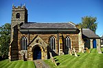 More images |
| Church of St Nicholas | Eydon | Church | 13th century | 4 February 1969 | SP5411249981 52°08′44″N 1°12′38″W / 52.145476°N 1.210643°W / 52.145476; -1.210643 (Church of St Nicholas) | 1040476 |  More images |
| Abbey Lodge | Farthinghoe | House | 15th century | 4 February 1969 | SP5358439791 52°03′14″N 1°13′12″W / 52.053922°N 1.219958°W / 52.053922; -1.219958 (Abbey Lodge) | 1286510 | Upload Photo |
| Church of St Mary the Virgin | Gayton | Parish Church | 14th century | 17 May 1960 | SP7060254791 52°11′13″N 0°58′07″W / 52.186855°N 0.968703°W / 52.186855; -0.968703 (Church of St Mary the Virgin) | 1041071 |  More images |
| Church of St Mary the Virgin | Grafton Regis | Church | Early 13th century | 17 May 1960 | SP7589246922 52°06′56″N 0°53′35″W / 52.115421°N 0.893095°W / 52.115421; -0.893095 (Church of St Mary the Virgin) | 1040819 | 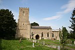 More images |
| The Chantry | Grafton Regis | House | 17th century | 1 December 1951 | SP7587046854 52°06′53″N 0°53′36″W / 52.114812°N 0.893431°W / 52.114812; -0.893431 (The Chantry) | 1040820 | Upload Photo |
| Church of St Peter | Greatworth | Parish Church | 13th century | 18 March 1985 | SP5523642382 52°04′37″N 1°11′44″W / 52.077053°N 1.195449°W / 52.077053; -1.195449 (Church of St Peter) | 1192679 | 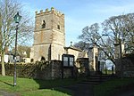 More images |
| Pair of Headstones about 5m south-west of South Porch of Church of St Peter | Greatworth | Gravestone | Late 18th century | 18 March 1985 | SP5523342372 52°04′37″N 1°11′44″W / 52.076963°N 1.195495°W / 52.076963; -1.195495 (Pair of Headstones about 5m south-west of South Porch of Church of St Peter) | 1371828 | Upload Photo |
| Church of St John the Baptist | Piddington, Hackleton | Church | 13th century | 3 May 1968 | SP8008954601 52°11′02″N 0°49′48″W / 52.183853°N 0.830008°W / 52.183853; -0.830008 (Church of St John the Baptist) | 1190138 |  More images |
| Church of St Mary | Horton, Hackleton | Church | 13th century | 3 May 1968 | SP8194154336 52°10′52″N 0°48′11″W / 52.181199°N 0.80299°W / 52.181199; -0.80299 (Church of St Mary) | 1190174 | 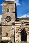 More images |
| Church of St Peter and St Paul | Preston Deanery, Hackleton | Church | 12th century | 3 May 1968 | SP7884255679 52°11′37″N 0°50′53″W / 52.193722°N 0.847993°W / 52.193722; -0.847993 (Church of St Peter and St Paul) | 1041557 |  More images |
| The Menagerie | Horton, Hackleton | Gate | Late 1750s | 3 May 1968 | SP8227053472 52°10′24″N 0°47′54″W / 52.173385°N 0.798389°W / 52.173385; -0.798389 (The Menagerie) | 1041554 |  More images |
| Church of All Saints | Harpole | Parish Church | C12-C15 | 3 May 1968 | SP6906160965 52°14′33″N 0°59′24″W / 52.242548°N 0.989982°W / 52.242548; -0.989982 (Church of All Saints) | 1041038 | 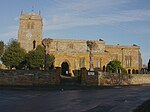 More images |
| Church of St John the Baptist | Hartwell | Church | Medieval | 3 May 1968 | SP7852650430 52°08′48″N 0°51′14″W / 52.146586°N 0.853828°W / 52.146586; -0.853828 (Church of St John the Baptist) | 1040826 |  More images |
| Astwell Castle | Helmdon | Manor House | 15th century | 11 September 1953 | SP6079444072 52°05′30″N 1°06′51″W / 52.091664°N 1.11406°W / 52.091664; -1.11406 (Astwell Castle) | 1041132 |  More images |
| Church of St Mary Magdalene | Helmdon | Church | 14th century | 9 February 1969 | SP5901143186 52°05′02″N 1°08′25″W / 52.083892°N 1.140235°W / 52.083892; -1.140235 (Church of St Mary Magdalene) | 1371508 |  More images |
| Astrop House | Astrop, Kings Sutton | House | c. 1740 | 31 August 1960 | SP5087836794 52°01′38″N 1°15′36″W / 52.027234°N 1.259862°W / 52.027234; -1.259862 (Astrop House) | 1226127 |  More images |
| Manor House | Kings Sutton | House | Early 17th century | 11 September 1953 | SP4979636051 52°01′14″N 1°16′33″W / 52.020653°N 1.275739°W / 52.020653; -1.275739 (Manor House) | 1226232 |  |
| The Courthouse | Kings Sutton | House | Late 16th century | 4 February 1969 | SP4986536065 52°01′15″N 1°16′29″W / 52.020772°N 1.274732°W / 52.020772; -1.274732 (The Courthouse) | 1226138 | Upload Photo |
| Church of St Martin | Litchborough | Parish Church | 13th century | 17 May 1960 | SP6326654257 52°10′59″N 1°04′34″W / 52.182943°N 1.076092°W / 52.182943; -1.076092 (Church of St Martin) | 1371572 |  More images |
| Church of St Mary the Virgin | Little Houghton | Church | C13-C15 | 3 May 1968 | SP8034059629 52°13′44″N 0°49′31″W / 52.229011°N 0.825147°W / 52.229011; -0.825147 (Church of St Mary the Virgin) | 1041558 |  More images |
| Little Houghton House and attached Office Wing | Little Houghton | House | c. 1825 | 6 September 1988 | SP8054659688 52°13′46″N 0°49′20″W / 52.229511°N 0.822117°W / 52.229511; -0.822117 (Little Houghton House and attached Office Wing) | 1190269 |  More images |
| Church of St Peter and St Paul | Maidford | Church | 13th century | 17 May 1960 | SP6097052539 52°10′04″N 1°06′36″W / 52.167758°N 1.109977°W / 52.167758; -1.109977 (Church of St Peter and St Paul) | 1371650 |  More images |
| Marston House | Marston St. Lawrence | Country House | C16-C17 | 11 September 1953 | SP5368342180 52°04′31″N 1°13′05″W / 52.075389°N 1.218139°W / 52.075389; -1.218139 (Marston House) | 1371491 | Upload Photo |
| Church of the Holy Cross | Milton Malsor | Church | Late 13th century to mid 14th century | 3 May 1968 | SP7366955558 52°11′36″N 0°55′25″W / 52.193349°N 0.923683°W / 52.193349; -0.923683 (Church of the Holy Cross) | 1040957 |  More images |
| Church of St Mary | Moreton Pinkney | Church | Late 12th century | 4 February 1969 | SP5740249052 52°08′12″N 1°09′46″W / 52.136793°N 1.162726°W / 52.136793; -1.162726 (Church of St Mary) | 1293734 | 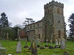 More images |
| Church of St Peter and St Paul | Nether Heyford | Parish Church | 13th century | 3 May 1968 | SP6596058714 52°13′22″N 1°02′09″W / 52.222693°N 1.035829°W / 52.222693; -1.035829 (Church of St Peter and St Paul) | 1041021 | 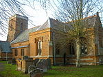 More images |
| Church of St James | Newbottle | Church | 1764 | 4 February 1969 | SP5236136915 52°01′41″N 1°14′18″W / 52.028184°N 1.238231°W / 52.028184; -1.238231 (Church of St James) | 1265911 | 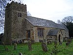 More images |
| Manor House | Great Purston, Newbottle | Manor House | 16th century | 4 February 1969 | SP5176139514 52°03′06″N 1°14′48″W / 52.051605°N 1.246583°W / 52.051605; -1.246583 (Manor House) | 1226244 |  |
| Manor House | Newbottle | Manor House | Early 16th century | 11 September 1953 | SP5237836961 52°01′43″N 1°14′17″W / 52.028596°N 1.237976°W / 52.028596; -1.237976 (Manor House) | 1226294 | Upload Photo |
| Church of Holy Cross | Pattishall | Parish Church | C11-C15 | 17 May 1960 | SP6711354295 52°10′58″N 1°01′11″W / 52.182831°N 1.019827°W / 52.182831; -1.019827 (Church of Holy Cross) | 1371539 | 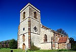 More images |
| Church of St James the Great | Paulerspury | Church | 13th century | 17 May 1960 | SP7156845496 52°06′11″N 0°57′24″W / 52.103178°N 0.95653°W / 52.103178; -0.95653 (Church of St James the Great) | 1041108 |  More images |
| Church of St Bartholomew | Furtho, Potterspury | Church | 12th century | 17 June 1960 | SP7734343088 52°04′51″N 0°52′22″W / 52.080757°N 0.872778°W / 52.080757; -0.872778 (Church of St Bartholomew) | 1191073 | 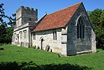 More images |
| Dovecote at Manor Farm | Furtho, Potterspury | Dovecote | Late 15th century | 18 May 1988 | SP7729943028 52°04′49″N 0°52′24″W / 52.080224°N 0.873434°W / 52.080224; -0.873434 (Dovecote at Manor Farm) | 1041652 | 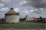 More images |
| Stable Block at Wakefield Lodge and attached Walls, Outbuildings and Gatepiers | Potterspury | House | Mid 18th century | 1 December 1951 | SP7384142506 52°04′34″N 0°55′26″W / 52.076003°N 0.923997°W / 52.076003; -0.923997 (Stable Block at Wakefield Lodge and attached Walls, Outbuildings and Gatepiers) | 1190683 | Upload Photo |
| Wakefield Lodge | Potterspury | Country House | 1748–1750 | 1 December 1951 | SP7375242550 52°04′35″N 0°55′31″W / 52.07641°N 0.925286°W / 52.07641; -0.925286 (Wakefield Lodge) | 1371656 |  More images |
| Church of St John the Baptist | Quinton | Church | Late Norman | 3 May 1968 | SP7767654330 52°10′54″N 0°51′55″W / 52.181762°N 0.865356°W / 52.181762; -0.865356 (Church of St John the Baptist) | 1371303 | 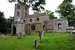 More images |
| Church of St Mary the Virgin | Roade | Church Hall | 1972 | 3 May 1968 | SP7573951867 52°09′36″N 0°53′39″W / 52.159891°N 0.894229°W / 52.159891; -0.894229 (Church of St Mary the Virgin) | 1294257 |  More images |
| Church of St Peter and St Paul | Rothersthorpe | Parish Church | 13th century | 3 May 1968 | SP7133456664 52°12′11″N 0°57′22″W / 52.2031°N 0.956°W / 52.2031; -0.956 (Church of St Peter and St Paul) | 1191724 |  More images |
| East Pavillion and attached Quadrant Colonnade | Stoke Park, Stoke Bruerne | House | c1629-35 | 1 December 1951 | SP7410948773 52°07′56″N 0°55′07″W / 52.132301°N 0.918726°W / 52.132301; -0.918726 (East Pavillion and attached Quadrant Colonnade) | 1040911 | 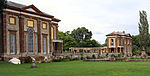 |
| West Pavillion and attached Quadrant Colonnade | Stoke Park, Shutlanger | Pavilion | c1629-35 | 1 December 1951 | SP7406648726 52°07′55″N 0°55′10″W / 52.131884°N 0.919364°W / 52.131884; -0.919364 (West Pavillion and attached Quadrant Colonnade) | 1371608 | |
| Church of St Mary the Virgin | Stoke Bruerne | Church | Late 12th century | 17 May 1960 | SP7406849838 52°08′31″N 0°55′09″W / 52.141879°N 0.919093°W / 52.141879; -0.919093 (Church of St Mary the Virgin) | 1040946 | 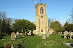 More images |
| Church of St James | Sulgrave | Church | Late Saxon | 4 February 1969 | SP5569045342 52°06′13″N 1°11′18″W / 52.103617°N 1.188343°W / 52.103617; -1.188343 (Church of St James) | 1040418 |  More images |
| Church of St James | Syresham | Church | 13th century | 4 February 1969 | SP6309041964 52°04′21″N 1°04′51″W / 52.072458°N 1.080942°W / 52.072458; -1.080942 (Church of St James) | 1190438 |  More images |
| Manor House | Thorpe Mandeville | Manor House | Early 18th century | 11 September 1953 | SP5331444965 52°06′02″N 1°13′23″W / 52.100461°N 1.223088°W / 52.100461; -1.223088 (Manor House) | 1041127 | Upload Photo |
| Church of St John the Baptist | Tiffield | Church | 13th century | 17 May 1960 | SP6991751629 52°09′31″N 0°58′46″W / 52.158519°N 0.979371°W / 52.158519; -0.979371 (Church of St John the Baptist) | 1040916 |  More images |
| No 88 Watling St East (the Chantry House) and attached Forecourt Walls and Gateway | Towcester | House | 15th century | 1 August 1979 | SP6935648684 52°07′56″N 0°59′17″W / 52.132117°N 0.988171°W / 52.132117; -0.988171 (No 88 Watling St East (the Chantry House) and attached Forecourt Walls and Gateway) | 1189997 |  More images |
| Park Farmhouse | Handley, Towcester | Farmhouse | 1601 | 19 August 1976 | SP6732447102 52°07′05″N 1°01′05″W / 52.118147°N 1.018165°W / 52.118147; -1.018165 (Park Farmhouse) | 1189876 | Upload Photo |
| 157 Watling Street West | Towcester | House | Mid 18th century | 1 December 1951 | SP6936248581 52°07′52″N 0°59′17″W / 52.13119°N 0.988104°W / 52.13119; -0.988104 (157 Watling Street West) | 1040834 | Upload Photo |
| Church of St Mary | Wappenham | Church | 13th century | 17 May 1960 | SP6250045666 52°06′21″N 1°05′20″W / 52.105803°N 1.088871°W / 52.105803; -1.088871 (Church of St Mary) | 1190507 |  More images |
| The Laurels | Wappenham | Farmhouse | Early 18th century | 1 December 1951 | SP6269145747 52°06′23″N 1°05′10″W / 52.10651°N 1.086068°W / 52.10651; -1.086068 (The Laurels) | 1293793 | Upload Photo |
| The Manor | Wappenham | Manor House | 1702 | 1 December 1951 | SP6246645682 52°06′21″N 1°05′22″W / 52.105951°N 1.089364°W / 52.105951; -1.089364 (The Manor) | 1190469 | Upload Photo |
| Church of St Mary | Warkworth | Church | 14th century | 4 February 1969 | SP4865140719 52°03′46″N 1°17′30″W / 52.062719°N 1.291761°W / 52.062719; -1.291761 (Church of St Mary) | 1226297 |  More images |
| Church of St Mary | Weedon Lois, Weston and Weedon | Church | c. 1100 | 17 May 1960 | SP6016046979 52°07′04″N 1°07′22″W / 52.117865°N 1.122801°W / 52.117865; -1.122801 (Church of St Mary) | 1371888 |  More images |
| Manor House Farmhouse, Outbuilding and Garden Wall | Plumpton, Weston and Weedon | Farmhouse | Early 17th century | 1 December 1951 | SP5991048433 52°07′51″N 1°07′34″W / 52.130963°N 1.126196°W / 52.130963; -1.126196 (Manor House Farmhouse, Outbuilding and Garden Wall) | 1293468 | Upload Photo |
| Weston Hall | Weston, Weston and Weedon | House | Late 17th century | 4 July 1985 | SP5913446916 52°07′03″N 1°08′16″W / 52.117409°N 1.137794°W / 52.117409; -1.137794 (Weston Hall) | 1040401 |  More images |
| Church of St Mary | Whittlebury | Church | 13th century | 17 May 1960 | SP6896044230 52°05′32″N 0°59′41″W / 52.092128°N 0.994856°W / 52.092128; -0.994856 (Church of St Mary) | 1371529 |  More images |
| Church of St John the Evangelist | Wicken | Church | Medieval | 17 May 1960 | SP7451139500 52°02′56″N 0°54′54″W / 52.048892°N 0.914878°W / 52.048892; -0.914878 (Church of St John the Evangelist) | 1371267 | 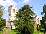 More images |
| Wicken Country Hotel | Wicken | Country House | 1703 | 1 December 1951 | SP7431539465 52°02′55″N 0°55′04″W / 52.048604°N 0.917743°W / 52.048604; -0.917743 (Wicken Country Hotel) | 1041624 | Upload Photo |
| Manor House and attached Walls | Woodend | Manor House | Late 17th century | 1 December 1951 | SP6158049311 52°08′19″N 1°06′06″W / 52.138673°N 1.101643°W / 52.138673; -1.101643 (Manor House and attached Walls) | 1190155 |  More images |
| Church of St Andrew | Yardley Hastings | Church | 13th century | 3 May 1968 | SP8661657063 52°12′18″N 0°44′02″W / 52.204997°N 0.733938°W / 52.204997; -0.733938 (Church of St Andrew) | 1041535 |  More images |
| The Old Rectory | Yardley Hastings | House | 1935 | 3 May 1968 | SP8642057323 52°12′27″N 0°44′12″W / 52.207365°N 0.736739°W / 52.207365; -0.736739 (The Old Rectory) | 1041541 | Upload Photo |
Notes
- ^ The date given is the date used by Historic England as significant for the initial building or that of an important part in the structure's description.
- ^ Sometimes known as OSGB36, the grid reference is based on the British national grid reference system used by the Ordnance Survey.
- ^ The "List Entry Number" is a unique number assigned to each listed building and scheduled monument by Historic England.
External links
- v
- t
- e
- Bedfordshire
- Berkshire
- Bristol
- Buckinghamshire
- Cambridgeshire
- Cheshire
- Cornwall
- Cumbria
- Derbyshire
- Devon
- Dorset
- Durham
- East Sussex
- East Riding of Yorkshire
- Essex
- Gloucestershire
- Greater London
- Greater Manchester
- Hampshire
- Herefordshire
- Hertfordshire
- Isle of Wight
- Kent
- Lancashire
- Leicestershire
- Lincolnshire
- Merseyside
- Norfolk
- North Yorkshire
- Northamptonshire
- Northumberland
- Nottinghamshire
- Oxfordshire
- Rutland
- Shropshire
- Somerset
- South Yorkshire
- Staffordshire
- Suffolk
- Surrey
- Tyne and Wear
- Warwickshire
- West Midlands
- West Sussex
- West Yorkshire
- Wiltshire
- Worcestershire
- Allerdale
- Amber Valley
- Ashford
- Babergh
- Barrow-in-Furness
- Basildon
- Basingstoke and Deane
- Bath and North East Somerset
- Bolsover
- Boston
- Bournemouth
- Bradford
- Braintree
- Breckland
- Brentwood
- Brighton and Hove
- Bristol
- Broadland
- Calderdale
- Cambridge
- Camden
- Canterbury
- Carlisle
- Castle Point
- Chelmsford
- Cheltenham
- Cherwell
- Cheshire East
- Cheshire West and Chester
- Chesterfield
- Chiltern
- Christchurch
- Colchester
- Copeland
- Corby
- Cotswold
- Dartford
- Daventry
- Dover
- East Cambridgeshire
- Exeter
- Mendip
- North Somerset
- North Yorkshire (district)
- Poole
- Sedgemoor
- South Somerset
- Stoke-on-Trent
- Taunton Deane
- West Somerset
- York


