Groais Island
You can help expand this article with text translated from the corresponding article in Dutch. Click [show] for important translation instructions.
- Machine translation, like DeepL or Google Translate, is a useful starting point for translations, but translators must revise errors as necessary and confirm that the translation is accurate, rather than simply copy-pasting machine-translated text into the English Wikipedia.
- Do not translate text that appears unreliable or low-quality. If possible, verify the text with references provided in the foreign-language article.
- You must provide copyright attribution in the edit summary accompanying your translation by providing an interlanguage link to the source of your translation. A model attribution edit summary is
Content in this edit is translated from the existing Dutch Wikipedia article at [[:nl:Groais Island]]; see its history for attribution. - You may also add the template
{{Translated|nl|Groais Island}}to the talk page. - For more guidance, see Wikipedia:Translation.
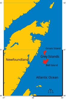
Groais Island is one of the Grey Islands, Bell Island being the other. It has an area of 41 km2 and is located off Newfoundland's Great Northern Peninsula to the east in the Atlantic Ocean in Canada.[1] The island is uninhabited, but was used earlier by fishermen.
The island is hilly, rising to over 100 metres. James Cook visited the island on 7 July 1754.[2] The northern coastline of Groais Island has high cliffs rising over 100 metres from the ocean. Although the ocean is mostly ice-covered in the region from January to April, the prevailing westerly winds often create open leads of water around the island.
Groais Island is important for birds during both the breeding and wintering season.
See also
Sources
- IBA, birds
- Cal Coish, The Hitch-Hiker, page 20
50°56′N 55°36′W / 50.933°N 55.600°W / 50.933; -55.600
- v
- t
- e


