Hatsi
Place
Hatsi Հացի | |
|---|---|
| Çörəkli | |
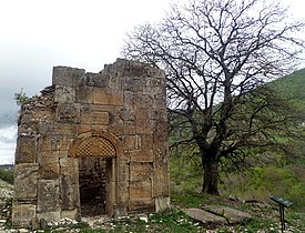
 Bri Yeghtsi monastic complex near Hatsi | |
| 39°50′41″N 46°57′27″E / 39.84472°N 46.95750°E / 39.84472; 46.95750 | |
| Country |  Azerbaijan Azerbaijan |
| • District | Khojavend |
| Population (2015)[1] | |
| • Total | 234 |
| Time zone | UTC+4 (AZT) |
Hatsi (Armenian: Հացի, also Gatsi) or Chorakli (Azerbaijani: Çörəkli) is a village located in the Khojavend District of Azerbaijan, in the region of Nagorno-Karabakh. The village had an ethnic Armenian-majority population before 2023 and in 1989.[2]
History
During the Soviet period, the village was a part of the Martuni District of the Nagorno-Karabakh Autonomous Oblast.
Historical heritage sites
Historical heritage sites in and around the village include the monastery complex of Bri Yeghtsi (Armenian: Բռի եղցի) from between the 7th and 17th centuries, and a 13th-century mural khachkar.[1]
Economy and culture
The population is mainly engaged in agriculture and animal husbandry. As of 2015, the village has a municipal building, a house of culture, a school, and a medical centre.[1]
Demographics
The village had 234 inhabitants in 2005,[3] and 234 inhabitants in 2015.[1]
Gallery
- Bri Yeghtsi monastic complex near Hatsi
-
-

-


References
- ^ a b c d Hakob Ghahramanyan. "Directory of socio-economic characteristics of NKR administrative-territorial units (2015)".
- ^ Андрей Зубов. "Андрей Зубов. Карабах: Мир и Война". drugoivzgliad.com. Archived from the original on 2020-10-20.
- ^ "The Results of the 2005 Census of the Nagorno-Karabakh Republic" (PDF). National Statistic Service of the Republic of Artsakh. Archived from the original (PDF) on 2011-03-02. Retrieved 2021-01-17.
External links
Wikimedia Commons has media related to Çörəkli.
- Hatsi at GEOnet Names Server
- v
- t
- e
Martuni Province
Capital: Martuni

- Zoravan (Nerkin Chartar)
- Jivani
- Sargsashen
- Shekher
- Vazgenashen
- Zardanashen

Portal:
 Geography

 | This Artsakh location article is a stub. You can help Wikipedia by expanding it. |
- v
- t
- e
 | This Khojavend District location article is a stub. You can help Wikipedia by expanding it. |
- v
- t
- e


