Hiawatha, Minneapolis
Neighborhood of Longfellow, Minneapolis
Neighborhood in Hennepin, Minnesota, United States
Hiawatha | |
|---|---|
Neighborhood | |
 Location of Hiawatha within the U.S. city of Minneapolis | |
| Country | United States |
| State | Minnesota |
| County | Hennepin |
| City | Minneapolis |
| Community | Longfellow |
| City Council Ward | 12 |
| Government | |
| • Council Member | Aurin Chowdhury |
| Area [1] | |
| • Total | 1.316 sq mi (3.41 km2) |
| Population (2020)[2] | |
| • Total | 6,298 |
| • Density | 4,800/sq mi (1,800/km2) |
| Time zone | UTC-6 (CST) |
| • Summer (DST) | UTC-5 (CDT) |
| ZIP code | 55406, 55417 |
| Area code | 612 |
| Census | Pop. | Note | %± |
|---|---|---|---|
| 1980 | 5,627 | — | |
| 1990 | 5,759 | 2.3% | |
| 2000 | 5,304 | −7.9% | |
| 2010 | 5,461 | 3.0% | |
| 2020 | 6,298 | 15.3% |
Hiawatha is a neighborhood within the larger Longfellow community in Minneapolis. It is bordered by 40th Street to the north, the Mississippi River to the east, 54th Street East to the south, and Hiawatha Avenue to the west. Its neighbors are Howe to the north, the Mississippi River to the east, Minnehaha Park and the Minnehaha neighborhood to the south, and Ericsson and Standish to the west.
Hiawatha is in City Council Ward 12,[3] represented by Aurin Chowdhury. 44°55′12″N 93°12′38″W / 44.9200°N 93.2106°W / 44.9200; -93.2106[4]
Landmarks and Amenities
Significant locations in Hiawatha include:
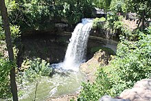
- Minnehaha Regional Park, a MPRB property featuring Minnehaha Falls, the restaurant Sea Salt, and the Minnehaha Dog Park,[5] designated as the Minnehaha Historic District[6]
- Hiawatha Elementary School,[7] a K-2 public school
- Minnehaha Academy, a private college preparatory school, has their elementary and middle school campus on 42nd Street and West River Parkway.[8]
- John H. Stevens House on 4901 Minnehaha Avenue[9]
- The 46th Street Station and the 50th/Minnehaha Station on the Metro Blue Line[10]
- The Hiawatha Avenue Mural, designed by Sara Rotholz Weiner to be painted on a grain elevator at the corner of Hiawatha Avenue and East 41st Street[11] [12]
| Hiawatha Avenue Mural | |
|---|---|
 | |
| Artist | Sara Rotholz Weiner |
| Year | 1990 (1990)-1992 (1992) |
| Type | Mural |
| Location | Minneapolis |
| Coordinates | 44°55′41″N 93°13′23″W / 44.92797°N 93.22311°W / 44.92797; -93.22311 |
References
- ^ "Hiawatha neighborhood in Minneapolis, Minnesota (MN), 55406, 55417 detailed profile". City-Data. 2011. Retrieved 2013-11-12.
- ^ "Hiawatha neighborhood data". Minnesota Compass. Retrieved 2023-02-19.
- ^ "Find My Ward". City of Minneapolis. Retrieved 19 April 2024.
- ^ Hiawatha, Minneapolis, MN. Google Earth. Retrieved 2011-03-09.
- ^ "Minnehaha Regional Park". Minneapolis Park and Recreation Board. Retrieved 23 April 2024.
- ^ "Minnehaha Historic District". City of Minneapolis. Retrieved 23 April 2024.
- ^ "About Hiawatha". Hiawatha Elementary School. Minneapolis Public Schools. Retrieved 23 April 2024.
- ^ "About Us". Minnehaha Academy. Retrieved 23 April 2024.
- ^ "John H. Stevens House". Minneapolis Park and Recreation Board. Retrieved 23 April 2024.
- ^ "Blue Line Map". Metro Transit. Retrieved 23 April 2024.
- ^ "After 22 years, Hiawatha Avenue grain elevator mural often goes unnoticed". Twin Cities Daily Planet. 4 February 2014. Archived from the original on 2 March 2014.
- ^ Longfellow/Nokomis Messenger. June 1992. http://www.longfellownokomismessenger.com/
- v
- t
- e
- Harrison
- Hawthorne
- Jordan
- Near North
- Sumner-Glenwood
- Willard-Hay
- 38th Street
- Cedar Avenue
- Central Avenue
- Franklin Avenue East
- East Lake Street
- Lowry Avenue North
- West Broadway
For a more comprehensive list, List of neighborhoods in Minneapolis.
Places adjacent to Hiawatha, Minneapolis | |
|---|---|


This article about a location in Hennepin County, Minnesota is a stub. You can help Wikipedia by expanding it. |
- v
- t
- e


