Hume County
Map all coordinates using OpenStreetMap
Download coordinates as:
- KML
- GPX (all coordinates)
- GPX (primary coordinates)
- GPX (secondary coordinates)
Cadastral in New South Wales, Australia
| Hume New South Wales | |||||||||||||||
|---|---|---|---|---|---|---|---|---|---|---|---|---|---|---|---|
 Location in New South Wales | |||||||||||||||
| |||||||||||||||

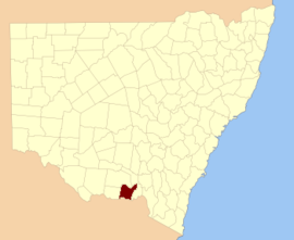
Hume County is one of the 141 cadastral divisions of New South Wales. It contains the town of Culcairn.
Hume County was named in honour of the explorer Hamilton Hume (1797-1873).[1]
Parishes within this county
A full list of parishes found within this county; their current LGA and mapping coordinates to the approximate centre of each location is as follows:
| Parish | LGA | Coordinates |
|---|---|---|
| Billabong Forest | Federation Council | 35°44′54″S 146°18′04″E / 35.74833°S 146.30111°E / -35.74833; 146.30111 (Billabong Forest) |
| Brocklesby | Greater Hume Shire Council | 35°47′54″S 146°39′04″E / 35.79833°S 146.65111°E / -35.79833; 146.65111 (Brocklesby) |
| Buckargingah | Greater Hume Shire Council | 35°29′54″S 147°09′04″E / 35.49833°S 147.15111°E / -35.49833; 147.15111 (Buckargingah) |
| Bulgandry | Greater Hume Shire Council | 35°35′12″S 146°38′19″E / 35.58667°S 146.63861°E / -35.58667; 146.63861 (Bulgandry) |
| Bungowannah | Greater Hume Shire Council | 36°00′54″S 146°48′04″E / 36.01500°S 146.80111°E / -36.01500; 146.80111 (Bungowannah) |
| Buraja | Federation Council | 35°52′54″S 146°24′04″E / 35.88167°S 146.40111°E / -35.88167; 146.40111 (Buraja) |
| Burrangong | Federation Council | 35°27′54″S 146°22′04″E / 35.46500°S 146.36778°E / -35.46500; 146.36778 (Burrangong) |
| Burrangong | Federation Council | 35°29′54″S 146°22′04″E / 35.49833°S 146.36778°E / -35.49833; 146.36778 (Burrangong) |
| Burrumbuttock | Greater Hume Shire Council | 35°48′54″S 146°47′04″E / 35.81500°S 146.78444°E / -35.81500; 146.78444 (Burrumbuttock) |
| Castlestead | Greater Hume Shire Council | 35°48′54″S 146°54′04″E / 35.81500°S 146.90111°E / -35.81500; 146.90111 (Castlestead) |
| Collendina | Federation Council | 35°58′54″S 146°14′04″E / 35.98167°S 146.23444°E / -35.98167; 146.23444 (Collendina) |
| Comer | Greater Hume Shire Council | 35°29′54″S 147°01′04″E / 35.49833°S 147.01778°E / -35.49833; 147.01778 (Comer) |
| Comer | Greater Hume Shire Council | 35°32′54″S 146°59′04″E / 35.54833°S 146.98444°E / -35.54833; 146.98444 (Comer) |
| Corowa | Federation Council | 35°57′44″S 146°21′44″E / 35.96222°S 146.36222°E / -35.96222; 146.36222 (Corowa) |
| Creighton | Greater Hume Shire Council | 35°42′54″S 147°01′04″E / 35.71500°S 147.01778°E / -35.71500; 147.01778 (Creighton) |
| Gibson | Greater Hume Shire Council | 35°39′54″S 146°37′04″E / 35.66500°S 146.61778°E / -35.66500; 146.61778 (Gibson) |
| Goombargana | Greater Hume Shire Council | 35°42′54″S 146°37′04″E / 35.71500°S 146.61778°E / -35.71500; 146.61778 (Goombargana) |
| Gordon | Federation Council | 35°38′54″S 146°19′04″E / 35.64833°S 146.31778°E / -35.64833; 146.31778 (Gordon) |
| Granville | Federation Council | 35°39′54″S 146°25′34″E / 35.66500°S 146.42611°E / -35.66500; 146.42611 (Granville) |
| Gray | Federation Council | 35°50′54″S 146°16′04″E / 35.84833°S 146.26778°E / -35.84833; 146.26778 (Gray) |
| Henty | Greater Hume Shire Council | 35°29′54″S 147°04′04″E / 35.49833°S 147.06778°E / -35.49833; 147.06778 (Henty) |
| Henty | Greater Hume Shire Council | 35°35′54″S 147°00′04″E / 35.59833°S 147.00111°E / -35.59833; 147.00111 (Henty) |
| Hindmarsh | Greater Hume Shire Council | 35°42′54″S 146°43′04″E / 35.71500°S 146.71778°E / -35.71500; 146.71778 (Hindmarsh) |
| Hovell | Greater Hume Shire Council | 35°52′54″S 146°45′04″E / 35.88167°S 146.75111°E / -35.88167; 146.75111 (Hovell) |
| Howlong | Federation Council | 35°57′54″S 146°39′04″E / 35.96500°S 146.65111°E / -35.96500; 146.65111 (Howlong) |
| Kentucky | Federation Council | 35°51′54″S 146°32′04″E / 35.86500°S 146.53444°E / -35.86500; 146.53444 (Kentucky) |
| Lowes | Federation Council | 35°46′54″S 146°25′04″E / 35.78167°S 146.41778°E / -35.78167; 146.41778 (Lowes) |
| Mahonga Forest | Federation Council | 35°31′54″S 146°29′04″E / 35.53167°S 146.48444°E / -35.53167; 146.48444 (Mahonga Forest) |
| Mahonga | Federation Council | 35°31′54″S 146°33′04″E / 35.53167°S 146.55111°E / -35.53167; 146.55111 (Mahonga) |
| Moorwatha | Greater Hume Shire Council | 35°55′00″S 146°44′59″E / 35.91667°S 146.74972°E / -35.91667; 146.74972 (Moorwatha) |
| Morebringer | Greater Hume Shire Council | 35°53′54″S 146°37′04″E / 35.89833°S 146.61778°E / -35.89833; 146.61778 (Morebringer) |
| Morven | Greater Hume Shire Council | 35°44′54″S 147°04′04″E / 35.74833°S 147.06778°E / -35.74833; 147.06778 (Morven) |
| Osborne | Federation Council | 35°37′54″S 146°31′04″E / 35.63167°S 146.51778°E / -35.63167; 146.51778 (Osborne) |
| Piney Range | Greater Hume Shire Council | 35°44′54″S 146°49′04″E / 35.74833°S 146.81778°E / -35.74833; 146.81778 (Piney Range) |
| Quat Quatta | Federation Council | 35°56′54″S 146°33′04″E / 35.94833°S 146.55111°E / -35.94833; 146.55111 (Quat Quatta) |
| Rand | Federation Council | 35°29′54″S 146°27′04″E / 35.49833°S 146.45111°E / -35.49833; 146.45111 (Rand) |
| Richmond | Federation Council | 35°46′54″S 146°32′04″E / 35.78167°S 146.53444°E / -35.78167; 146.53444 (Richmond) |
| Richmond | Federation Council | 35°44′54″S 146°30′04″E / 35.74833°S 146.50111°E / -35.74833; 146.50111 (Richmond) |
| Round Hill | Greater Hume Shire Council | 35°37′54″S 147°01′04″E / 35.63167°S 147.01778°E / -35.63167; 147.01778 (Round Hill) |
| Ryan | Greater Hume Shire Council | 35°35′54″S 146°44′04″E / 35.59833°S 146.73444°E / -35.59833; 146.73444 (Ryan) |
| Sandy Ridges | Federation Council | 35°53′54″S 146°16′04″E / 35.89833°S 146.26778°E / -35.89833; 146.26778 (Sandy Ridges) |
| Sherwyn | Greater Hume Shire Council | 35°38′54″S 146°50′04″E / 35.64833°S 146.83444°E / -35.64833; 146.83444 (Sherwyn) |
| Stitt | Greater Hume Shire Council | 35°37′54″S 146°56′04″E / 35.63167°S 146.93444°E / -35.63167; 146.93444 (Stitt) |
| Thugga | Greater Hume Shire Council | 35°05′54″S 147°07′04″E / 35.09833°S 147.11778°E / -35.09833; 147.11778 (Thugga) |
| Walbundrie | Greater Hume Shire Council | 35°39′54″S 146°44′04″E / 35.66500°S 146.73444°E / -35.66500; 146.73444 (Walbundrie) |
| Walla Walla | Greater Hume Shire Council | 35°43′54″S 146°54′04″E / 35.73167°S 146.90111°E / -35.73167; 146.90111 (Walla Walla) |
| Wilson | Federation Council | 35°32′54″S 146°19′04″E / 35.54833°S 146.31778°E / -35.54833; 146.31778 (Wilson) |
References
- ^ "Hume County". Geographical Names Register (GNR) of NSW. Geographical Names Board of New South Wales.


