Indalsälven
You can help expand this article with text translated from the corresponding article in Swedish. (March 2022) Click [show] for important translation instructions.
- Machine translation, like DeepL or Google Translate, is a useful starting point for translations, but translators must revise errors as necessary and confirm that the translation is accurate, rather than simply copy-pasting machine-translated text into the English Wikipedia.
- Do not translate text that appears unreliable or low-quality. If possible, verify the text with references provided in the foreign-language article.
- You must provide copyright attribution in the edit summary accompanying your translation by providing an interlanguage link to the source of your translation. A model attribution edit summary is
Content in this edit is translated from the existing Swedish Wikipedia article at [[:sv:Indalsälven]]; see its history for attribution. - You may also add the template
{{Translated|sv|Indalsälven}}to the talk page. - For more guidance, see Wikipedia:Translation.
River in Sweden
| Indalsälven Jämtlandsälven, Litsälven, Storsjöälven | |
|---|---|
 One of the many hydropower plants of Indalsälven. | |
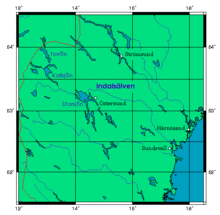 Location of Indalsälven | |
| Location | |
| Country | Sweden |
| County | Jämtland, Västernorrland |
| Physical characteristics | |
| Source | Åreälven |
| 2nd source | Järpströmmen |
| Mouth | Klingerfjärden, near Sundsvall. |
• location | Bothnian Sea, Västernorrland County |
• elevation | 0 m (0 ft) |
| Length | 420 km (260 mi)[1] |
| Basin size | 26,726.5 km2 (10,319.2 sq mi)[2] |
| Discharge | |
| • average | 460 m3/s (16,000 cu ft/s)[1] |
Indalsälven is one of Sweden's longest rivers with a total length of 430 kilometers. Among its tributaries are Kallströmmen, Långan, Hårkan and Ammerån. A total of 26 hydropower plants are placed along its course, making it the third most power producing river of Sweden.
The Indalsälven drains the Storsjön and culminates in the Bothnian Sea.
See also
References
- ^ a b "Indalsälven". Nationalencyklopedin (in Swedish). Retrieved 14 July 2010. (subscription required)
- ^ "Län och huvudavrinningsområden i Sverige" (PDF) (in Swedish). Swedish Meteorological and Hydrological Institute. Archived from the original (PDF) on 28 September 2018. Retrieved 14 July 2010.
62°30′N 17°26′E / 62.500°N 17.433°E / 62.500; 17.433
Authority control databases | |
|---|---|
| International |
|
| National |
|
- v
- t
- e


