Jericho Village Historic District
Historic district in Vermont, United States
United States historic place
Jericho Village Historic District | |
 | |
44°30′15″N 72°59′53″W / 44.50417°N 72.99806°W / 44.50417; -72.99806 | |
| Area | 96 acres (39 ha) |
|---|---|
| Built | 1858 (1858) |
| Architectural style | Greek Revival, Italianate, Federal |
| NRHP reference No. | 92001533[1] |
| Added to NRHP | November 5, 1992 |
The Jericho Village Historic District encompasses the historic industrial and commercial center of the village of Jericho, Vermont. Stretched along Vermont Route 15 south of Browns River, which powered the village's industries for many years, the village center includes a well-preserved array of 19th and early 20th-century buildings. The district was listed on the National Register of Historic Places in 1992.[1]
Description and history
The village of Jericho was established in the early 19th century around a series of mill privileges on the Browns River, which in the first half of the 19th century were mainly populate by saw and grist mills. Beginning in the 1820s the mills expanded to include woolen textile processing, and in the later 19th century the water power was harnessed for a variety of manufacturing operations, established to capitalize on the areas natural resources. The water-powered industries declined in the early decades of the 20th century, and most of the industrial buildings were torn down or destroyed by fire or flood. Fires also occasionally swept through the built-up areas of the village, but significant elements of its 19th-century form still predominate.[2]
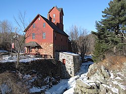
The historic district stretches along Vermont Route 15, which is known as Main Street in the western portion and Church Street in the eastern portion of the district. These two roads meet at a small triangular green, from which Lee River Road and Plains Road extend south. The western boundary of the district is roughly Lawrence Heights, and its eastern boundary roughly Griswold Street. In addition to buildings lining Church and Main Streets, the district includes properties on Lee River Road, Plains Road, and Old Pump Road, and it includes the archaeological remains of the mill complexes on either side of the Browns River, which roughly parallels VT 15. Most of the buildings are wood frame structures, with the brick Congregational Church (1826) and Galusha House (1790) as prominent exceptions. The village's industrial past remains visible in the Old Red Mill and Mill House (aka the Chittenden Mill), located at the western end of the historic district and now a museum property of the local historical society.[2]
See also
References
- ^ a b "National Register Information System". National Register of Historic Places. National Park Service. July 9, 2010.
- ^ a b Thomas Visser and Suzanne Jamele (1992). "NRHP nomination for Jericho Village Historic District". National Park Service. Retrieved October 26, 2016. with photos from 1992
- v
- t
- e
National Register of Historic Places in Chittenden County, Vermont
Historic
Landmarks
- Round Church
- Shelburne Farms
- Ticonderoga

- Martin M. Bates Farmstead
- Battery Street Historic District
- Buell Street–Bradley Street Historic District
- Charlotte Center Historic District
- Giles Chittenden Farmstead
- Church Street Historic District
- City Hall Park Historic District
- Downtown Essex Junction Commercial Historic District
- Fort Ethan Allen Historic District
- Gray Rocks
- Head of Church Street Historic District
- Hinesburg Town Forest
- Honey Hollow Camp
- Jericho Center Historic District
- Jericho Village Historic District
- Dan Johnson Farmstead
- Lakeside Development
- LeClair Avenue Historic District
- Mad River Glen Ski Area Historic District ‡
- Main Street–College Street Historic District
- Mount Philo State Park
- Murray–Isham Farm
- North Street Historic District
- Pearl Street Historic District
- Pine Street Industrial Historic District
- Preston–Lafreniere Farm
- Redstone Historic District
- Remington–Williamson Farm
- Sand Bar State Park
- Shelburne Village Historic District
- South Union Street Historic District
- South Willard Street Historic District
- Sutton Farm
- Underhill State Park
- University Green Historic District
- Wells-Richardson Complex
- M. S. Whitcomb Farm
- Williston Village Historic District
- Winooski Falls Mill District
- Burlington Bay Horse Ferry
- General Butler (shipwreck)
- O.J. Walker (shipwreck)
- Phoenix (shipwreck)
- Winooski Archeological Site
† This entry has been removed from the registry.
‡ This historic property also has portions in an adjacent county.
‡ This historic property also has portions in an adjacent county.


