Khirbet et-Tibbaneh
An ancient ruin in the Judean mountains
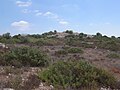
31°41′36″N 35°02′44″E / 31.69333°N 35.04556°E / 31.69333; 35.04556Khirbet et-Tibbâneh (Hurvat Tibneh / Kh. Tibna)(Arabic: خربة التبانة),[1] sometimes referred to by historical geographers as the Timnah of Judah (Hebrew: תמנה), is a small ruin situated on a high ridge in the Judaean mountains, in the Sansan Nature Reserve, 622 metres (2,041 ft) above sea level, about 3 kilometers east of Aviezer and ca. 7 kilometers southeast of Bayt Nattif.
The site is thought to have formerly borne the name Timnath (distinct from the Tel Batash-Timnah site associated with the biblical story of Samson in the lower foothills of Judea along the Sorek valley).[2] Khirbet et-Tibbaneh or Timnah is perched upon a high mountain ridge rising up from the Elah valley and is where the episode of Judah and Tamar is thought to have taken place.[2][3][4]
Etymology
Orientalists, Clermont-Ganneau and Edward Robinson, have made a point in showing the etymological Hebrew origins of certain Arabic place-names, saying that the Hebrew place-name Timnah was to be recognised in the Arabic corruption, Tibneh or Tibna.[5][6] John William McGarvey (1829–1911) who quotes Conder on the linguistic evidence of the name says that, in Arabic, "the substitution of B for M is so common (as in Tibneh for Timnah)..."[7][8] Both names have been preserved in the respective sites.
Site and identification
In ancient Jewish classical literature, two distinct sites in the land of Judah bore the name Timnath (Timnah).[9][10] The Book of Joshua records the names of two towns, both in the tribal inheritance of Judah and having the identical name of Timnath; the one Timnath (Josh. 15:10) being transcribed alongside the name of Beit Shemesh, while the other Timnath (Josh. 15:57) being transcribed alongside the name of Gibeah (of Judah), a town said to be Jab'a.[11][12] The Jerusalem Talmud (Sotah 1:8) relates the following tradition: "Rav has said: There were two Timnaths; one mentioned in connection with Judah, and the other mentioned in connection with Samson."[13] The Talmudic exegetes have explained that Samson, who lived in the hilltop town of Zorah near Beit Shemesh, is said to have 'gone down' to Timnath,[14] but Judah is said to have 'gone up' to Timnath.[15] Kh. et-Tibbâneh is thought to be the Timnath (Timnah) mentioned in connection with Judah and Tamar (Genesis 38: 13, 14),[16][17][18][19] although this view remains inconclusive.[10][20]
Khirbet et Tibbaneh (Tibna) was visited by Palestine Exploration Fund explorers, Conder and Kitchener, in the late 19th-century, where they described the ruin as follows: "Timnah - A town of Judah (Josh. XV. 57), mentioned with Gibeah. There is a ruin called Tibna near Jeb'a, in the higher hills of ʾArkûb, distinct from Tibneh (Sheet XVI), which represents the Timnah of Joshua XV.10."[21]
Others are unsure of its identification, since the site has yet to be fully excavated.[22][23]
Site's description
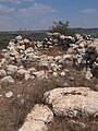
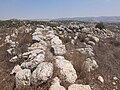
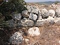
The ancient ruin sits on a high mountain ridge about 2 kilometers west of Khirbet Sanasin. The site lies 7 kilometres (4.3 mi) northeast of Adullam.[4] On its site is found the remnant of a square Iron Age fortress which apparently offered security along the route from the valley of Elah to Betar and to Jerusalem.[24] The area of the fortress is 30 x 30 meters (98 x 98 feet), where two walls made of fieldstones and ashlar masonry still remain, whose hollowed spaces were filled-in with smaller stones.[24] Amihai Mazar suggests that the structure served as either a fortress or an administrative center, and most likely manned by a garrison to secure the roads between the major towns of the Shephelah and the string of settlements along the edge of the hill region.[25]
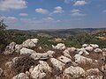
The mound is almost entirely strewn with razed boulders, and ancillary walls, partially standing, are to be seen on the ruin. On its eastern side is a steep declivity, descending down into the valley below, Wadi Tibbaneh (Wadi Tibna), where it joins Etzion Valley (Wady el Jindy) to its south at a drop of about 200 metres (660 ft). The valley seemed to have been used for horticulture in ages past. Sherds dot the landscape, with occasional carob trees, oaks and buckthorns. Near the site is a modern-day quarry and two ancient cisterns.[24] In close proximity to Khirbet et-Tibbaneh is the old military patrol road, leading from Tzur Hadassah to Aviezer.
History
Khirbet et-Tibbaneh (Tibna) is thought to be the "Tapuna" mentioned in the list of Thutmose III.[26]
Israeli archaeologist Michael Avi-Yonah also thinks the site to have been the Timnah (Thamnatha) mentioned in 1 Maccabees (9:50–52) and later mentioned by Josephus in Antiquities of the Jews 13.1.3, one of several places fortified by Bacchides in ca. 160 BCE after the death of Judas Maccabeus.[27] Others suggest that the account in Maccabees may refer to another Timna (Thamnatha), that called Khirbet Tibnah in southwestern Samaria at Mount Ephraim, about 14 kilometers (9 miles) northwest of Bethel.[28][29]
It is generally accepted that the Mishnaic scholar Simeon the Yemenite was born and raised in one of the two Timnahs during the waning years of the Second Temple period based on the vowels assigned to his name (Hebrew: שמעון התִּימְנִי, romanized: Šimʿon hat-Tîmnî). He is noted for saying: "A mamzer is anyone who is born from an [illegal] union for which his parents are liable to kareth." (Mishnah, Yebamot 4:13;[30] Babylonian Talmud, Yebamot 49a)[31], and which teaching comes to exclude a single parent who gave birth to a child outside of wedlock, and whose child is often wrongly called "bastard" under common law.[32]
Archaeological finds
As of 2018, the site at Khirbet Tibbaneh has yet to be excavated.[33] The site was surveyed by Dani Weiss, Boaz Zissu and Gideon Solimany of the Israel Antiquities Authority, who discovered a segment of an ancient road that was 200 m. long, 2.5 m. wide.[34] A cursory review of the site has revealed late Iron II sherds.[35]
Gallery
-
 Khirbet et-Tibbâneh
 -
 Walls of Timnah
 -
 General ruins
 -
 Timnath of Judah
 -
 Khirbet et-Tibbâneh
 -
 Remains of thick wall at Khirbet et-Tibbâneh
 -
 Ruin of Timnath (Tibbaneh)
 -
 Site at Khirbet et-Tibbâneh
 -
 Stone at Khirbet et-Tibbâneh
 -
 Thick wall at Timnath ruin
 -
 Three foundation stones
 -
 View looking north from ruin
 -
 View looking south
 -
 Walled structure


References
- ^ In the 1928–1947 Survey of Palestine map published by the National Library of Israel, Map no. 15-12 (at Grid number 154/122) is called Kh. et Tabbâna, but in the SWP Map number 17 published by the Palestine Exploration Fund, the same site is called Tibna.
- ^ a b Clermont-Ganneau (1875), p. 169
- ^ Rainey (1983), p. 5
- ^ a b Emerton (1975), p. 344
- ^ Clermont-Ganneau (1896), pp. 67–68, 214, where he wrote: (p. 214) "Tibneh, 'chopped straw', one would swear was Arabic, but it is beyond a doubt that it is the name of the town Timnah, brought into that shape by one of those popular etymologies which are as dear to the peasantry of Palestine as to those of our European countries." On pp. 67–68 he wrote: "One has to beware, however, of these appellations that appear to be of purely Arabic origin, they are often ancient Hebrew names converted by a process of popular etymology into words familiar to the Arabs. In many cases slight phonetic changes assist the process. These , by the bye, are not arbitrary, but are subject to real laws. Thus, for instance, the name of the Bible town of Thimnah has become in fellâh speech Tibneh, 'chopped straw'."
- ^ Robinson, E. (1860), p. 17
- ^ McGarvey, 2002, pp. 246-247
- ^ Palmer, E.H. (1881), p. 330, s.v. Tibna
- ^ Neubauer, A. (1868), pp. 102–103; Press, I. (1955), p. 974 (s.v. תמנה א)
- ^ a b Encyclopaedia Judaica (vol. 15), Jerusalem 1971, p. 1147 (s.v. Timnah)
- ^ An opinion expressed by historical geographer Klein, S. (1939), p. 198, and by PEF explorers Conder and Kitchener (SWP, III, 53). Jab'a, southeast of Bayt Nattif, is not far situated from Khirbet et-Tibbaneh.
- ^ Robinson (1841), p. 343 (note 4)
- ^ Same quote cited in Midrash Rabba (Genesis Rabba § 85 and Numbers Rabba 9:24) and in the Babylonian Talmud (Sotah 10a). The 14th-century Midrash Hagadol brings down this tradition under a variant name: "Rebbe has said," etc., instead of "Rav has said."
- ^ Judges 14:1
- ^ Genesis 38:13
- ^ Kelm & Mazar (1984), p. 58
- ^ Abel, F.M. (1938), p. 481, s.v. Thimna (1), citing Conder & Kitchener's SWP, III, p. 53.
- ^ Klein, S. (1922), p. 42
- ^ Avi-Yonah (1976), p. 100
- ^ Tristram, H.B. (1897), p. 66, who thought that it was one and the same place, where Samson had gone to take his wife, near the Sorek Valley.
- ^ Conder & Kitchener (1883), p. 53
- ^ Gibson & Negev (2001), p. 509 [s.v. Timnah (c)]
- ^ Schürer, 1891, p. 158–159, note 438.
- ^ a b c Meltzer, M. (2000), p. 213
- ^ Mazar, A. (1993), p. 16
- ^ Tristram, Henry Baker (1897), p. 83
- ^ Avi-Yonah, Michael (1963), p. 37 (note 7); Avi-Yonah, M. (1977), p. 53. (I. Roll agrees to this view. See: I Roll, "Bacchides' Fortifications and the Arteries of Traffic to Jerusalem in the Hellenistic Period", Eretz-Israel 25 (1996, pp. 509–514 [Hebrew]); Avi-Yonah, M. (1976), p. 100.
- ^ Kallai, Z. (1960), p. 96
- ^ Freedman, D.N. et al. (2000), p. 1312
- ^ "Mishnah Yevamot 4:13". www.sefaria.org.
- ^ "Yevamot 49a". www.sefaria.org.
- ^ Cohen, Shaye J. D. (1999). "The Beginnings of Jewishness: Boundaries, Varieties, Uncertainties". University of California Press.
- ^ Israeli archaeologist, Ze'ev Safrai, Correspondence
- ^ The Archaeological Survey of Israel; Site No.: 186, Kh. et-Tabbana
- ^ Mazar, Amihai (1981), p. 246
Bibliography
- Abel, F.M. (1938). Géographie de la Palestine (in French). Vol. 2. Paris: Gabalda.
- Avi-Yonah, M. (1963). Historical Geography of Palestine (in Hebrew). Jerusalem: Bialik Institute.
- Avi-Yonah, M. (1976). Gazetteer of Roman Palestine, Qedem - Monographs of the Institute of Archaeology [5]. Vol. 2. Jerusalem: Hebrew University of Jerusalem.
- Avi-Yonah, M. (1977). The Holy Land from the Persian to the Arab Conquests (536 B.C. to A.D. 640) – A Historical Geography. Grand Rapids. ISBN 978-0801000102.
{{cite book}}: CS1 maint: location missing publisher (link) - Clermont-Ganneau, C. (1875), The Site of the City of Adullam, Palestine Exploration Fund Quarterly Statement 7.3 (July), pp. 168–177
- Clermont-Ganneau, C.S. (1896). Archaeological Researches in Palestine During the Years 1873–1874. Vol. 2. London: Palestine Exploration Fund.
- Conder, C.R.; Kitchener, H.H. (1883). The Survey of Western Palestine: Memoirs of the Topography, Orography, Hydrography, and Archaeology. Vol. 3. London: Committee of the Palestine Exploration Fund.
- Emerton, J.A. (1975). "Some Problems in Genesis XXXVIII". Vetus Testamentum. 25 (2): 338–361. doi:10.2307/1516950. JSTOR 1516950.
- Freedman, D.N.; Myers, Allen C. (31 December 2000). Eerdmans Dictionary of the Bible. Amsterdam University Press. ISBN 978-90-5356-503-2.
- Gibson, S.; Negev, Avraham, eds. (2001), Archaeological Encyclopedia of the Holy Land, New York / London, ISBN 0-8264-1316-1
{{citation}}: CS1 maint: location missing publisher (link) - Guérin, V. (1869). Description Géographique Historique et Archéologique de la Palestine (in French). Vol. 1: Judee, pt. 2. Paris: L'Imprimerie Nationale.
- Kallai, Zechariah (1960). Northern Boundaries of Judah, from the Settlement of the Tribes Until the Beginning of the Hasmonaean Period (in Hebrew). Jerusalem.
{{cite book}}: CS1 maint: location missing publisher (link) - Kelm, G.L.; Mazar, A. (1984). "Timnah: A Biblical City in the Sorek Valley". Archaeology. 37 (3): 58–59, 78–79. JSTOR 41729127.
- Klein, S. (1922). Eretz Yisrael: Geography of Israel for High Schools and for the People (in Hebrew). Vienna: Menorah.
- Klein, S. (1939). Eretz Yehudah (The Land of Judah). Tel-Aviv.
{{cite book}}: CS1 maint: location missing publisher (link) (Hebrew) - Mazar, A. (1981). "The Excavations of Khirbet Abu et-Twain and the System of Iron Age Fortresses in Judah". Eretz-Israel (in Hebrew). 15.
- Mazar, A. (1993), "Abu Tuwein, Khirbet", in Stern, E. (ed.), The New Encyclopedia of Archaeological Excavations in the Holy Land, vol. 1, Jerusalem: Israel Exploration Society, ISBN 965-220-209-6
- McGarvey, J.W. (2002). Lands of the Bible: A Geographical and Topographical Description of Palestine, with Letters of Travel in Egypt, Syria, Asia Minor, and Greece. Adamant Media Corporation. ISBN 978-1-4021-9277-7.
- Meltzer, Muli, ed. (2000), Encyclopaedia Mapa - A Comprehensive Gazetteer of Israel Today, vol. 7, Tel-Aviv, ISBN 965-7009-92-8
{{citation}}: CS1 maint: location missing publisher (link) (OCLC 174742987) (Hebrew) - Neubauer, A. (1868). Géographie du Talmud (in French). Paris: Michel Lévy Frères.
- Palmer, E. H. (1881). The Survey of Western Palestine: Arabic and English Name Lists Collected During the Survey by Lieutenants Conder and Kitchener, R. E. Transliterated and Explained by E.H. Palmer. Committee of the Palestine Exploration Fund.
- Press, I., ed. (1955), "תמנה א", A Topographical-Historical Encyclopaedia of Palestine, vol. 4, Jerusalem: Rubin Mass, p. 974
- Rainey, A.F. (1983). "The Biblical Shephelah of Judah". Bulletin of the American Schools of Oriental Research. 251 (251). The University of Chicago Press on behalf of The American Schools of Oriental Research: 1–22. doi:10.2307/1356823. JSTOR 1356823. S2CID 163604987.
- Robinson, Edward; Smith, Eli (1841). Biblical Researches in Palestine, Mount Sinai and Arabia Petraea: A Journal of Travels in the year 1838. Vol. 2. Boston: Crocker & Brewster.
- Robinson, E.; Smith, E. (1860). Biblical Researches in Palestine and in the Adjacent Regions: A Journal of Travels in the year 1838. Vol. 2. Boston: Crocker & Brewster.
- Schürer, E. (1891). Geschichte des jüdischen Volkes im Zeitalter Jesu Christi [A History of the Jewish People in the Time of Jesus Christ]. Vol. 1. Translated by Miss Taylor. New York: Charles Scribner's Sons. pp. 158–159 (note 438).
- Tristram, H.B. (1897). Bible Places: Or, The Topography of the Holy Land: a Succinct Account of All the Places, Rivers, and Mountains of the Land of Israel. London.
{{cite book}}: CS1 maint: location missing publisher (link)
External links
- Survey of Western Palestine, 1880 Map, Map 17: IAA, Wikimedia commons


