Klapperhorn Mountain
Mountain in British Columbia, Canada


Klapperhorn Mountain
Location in British Columbia
Show map of British Columbia
Klapperhorn Mountain
Klapperhorn Mountain (Canada)
Show map of CanadaCanadian Rockies
Klapperhorn Mountain is a summit in British Columbia, Canada.
Description
Klapperhorn Mountain, elevation 2,301-meters (7,549-feet), is located in Mount Robson Provincial Park, just south and within view of the park's visitor centre. It is the northernmost peak of the Selwyn Range,[1] which is a subrange of the Canadian Rockies. Precipitation runoff from the peak drains north into the Fraser River. Topographic relief is significant as the summit rises 1,400 meters (4,600 ft) above the Robson Valley in 2 km (1.2 mi). The Yellowhead Highway (Highway 16) and Canadian National Railway traverse the northern base of the mountain. The nearest neighbor is line parent Overlander Mountain, 2.0 km (1.2 mi) to the southeast.
Etymology
The mountain was named by BC Parks on March 13, 1972,[2][4] and the toponym was officially adopted December 19, 1978, by the Geographical Names Board of Canada.[3] The mountain is a classic horn-shaped summit, which is notable for the frequency of its rockslides which are audible to campers and are a source of much curiosity and interest.[4]
Climate
Based on the Köppen climate classification, Klapperhorn Mountain is located in a subarctic climate zone with cold, snowy winters, and mild summers.[5] Winter temperatures can drop below −20 °C with wind chill factors below −30 °C.
See also
 Mountains portal
- Geography of British Columbia

Gallery
-
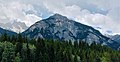 Klapperhorn Mountain from north
 -
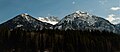 Overlander and Klapperhorn mountains
 -
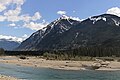 Klapperhorn Mountain viewed from the west along Highway 16


References
- ^ a b c d e "Klapperhorn Mountain, Peakvisor.com". Retrieved 2022-12-22.
- ^ a b "Klapperhorn Mountain". cdnrockiesdatabases.ca. Retrieved 2022-12-22.
- ^ a b c "Klapperhorn Mountain". Geographical Names Data Base. Natural Resources Canada. Retrieved 2022-12-22.
- ^ a b "Klapperhorn Mountain". BC Geographical Names. Retrieved 2022-12-22.
- ^ Peel, M. C.; Finlayson, B. L.; McMahon, T. A. (2007). "Updated world map of the Köppen−Geiger climate classification". Hydrol. Earth Syst. Sci. 11: 1633–1644. ISSN 1027-5606.
External links
- Mount Robson Provincial Park website—BC Parks
- Klapperhorn Mountain: weather forecast
- v
- t
- e
- Ball
- Bare
- Beaverfoot
- Blue
- Bow
- Crowsnest
- Elk
- Fairholme
- Fiddle
- Flathead
- Foothills
- High Rock
- Kananaskis
- Livingstone
- Lizard
- Maligne
- Massive
- Misty
- Morrissey
- Palliser
- President
- Queen Elizabeth
- Rainbow
- Ram
- Sawback
- Sentinel
- Slate
- South Jasper
- Sundance
- Terminal
- Tower of London
- Vermilion
- Victoria Cross
- Waputik
- Winston Churchill
- Continental Ranges
- Hart Ranges
- Muskwa Ranges
- Alberta
- Andromeda
- Assiniboine
- Athabasca
- Brazeau
- Bryce
- Cascade
- Castle
- Castleguard
- Clemenceau
- Columbia
- Cory
- Edith Cavell
- Forbes
- Hector
- Hosmer
- Hungabee
- Joffre
- Kitchener
- Lyell
- Heart
- Pilot
- Pyramid
- Resplendent
- Robson
- Rundle
- Sarbach
- Saskatchewan
- Smythe
- Snow Dome
- Stanley Peak
- Sulphur
- Temple
- Three Sisters
- Trinity
- Twin
- Ulysses
- Unnamed Alberta–BC mountain (formerly Mount Pétain)
- Whymper
see List of rivers of the Canadian Rockies and Category:Rivers of the Canadian Rockies
- Mountain Stoney
- Mountain Metis
| International | |
|---|---|
| National |
|
| Provincial (AB) |
|
| Provincial (BC) |
- See also
- Geography portal
- Canada portal
Places adjacent to Klapperhorn Mountain | ||||||||||||||||
|---|---|---|---|---|---|---|---|---|---|---|---|---|---|---|---|---|
| ||||||||||||||||


