Kohtla-Nõmme
Borough in Estonia
Borough with a municipality status in Ida-Viru County, Estonia

Flag

Coat of arms
(01.01.2009)
Kohtla-Nõmme is a borough (Estonian: alev) in Toila Parish, in Ida-Viru County, in northeastern Estonia. It had a population of 1,047 (as of 1 January 2009) and an area of 4.64 km².[1]
In the 1930s, New Consolidated Gold Fields opened a shale oil extraction complex at Kohtla-Nõmme. In 1937, the company opened the Kohtla underground mine. After the occupation of Estonia by the Soviet Union, the company was nationalized in 1940. The Kohtla-Nõmme shale oil extraction complex continued to operate until 1961. The underground mine stayed operational until 2001.[2] After that the Estonian Mining Museum was opened at the site.
-
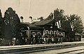 Kohtla railway station, destroyed in WWII
 -
 Kohtla mine in 1994
 -
 360° panorama of the Estonian Mining Museum


See also
References
- ^ "Population figure and composition". stat.ee – Statistics Estonia. Retrieved 29 January 2010.
- ^ Karu, Veiko; Valgma, Ingo; Kolats, Margit (2013). "Mine water as a potential source of energy from underground mined area in Estonian oil shale deposit" (PDF). Oil Shale. A Scientific-Technical Journal. 30 (2S). Estonian Academy Publishers: 336–362. doi:10.3176/oil.2013.2S.12. ISSN 0208-189X. Retrieved 2014-04-12.
External links
- Kohtla-Nõmme TV Mast
- v
- t
- e
- Kohtla-Nõmme


 | This Ida-Viru County location article is a stub. You can help Wikipedia by expanding it. |
- v
- t
- e


