La Guajira Terrane
Geological province in Colombia
| La Guajira Terrane | |
|---|---|
| Stratigraphic range: Late Cretaceous (emplaced) ~100–65 Ma PreꞒ Ꞓ O S D C P T J K Pg N | |
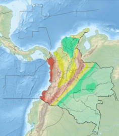
 La Guajira Terrane is enclosed by the Bucaramanga-Santa Marta Fault (orange) and northernmost Oca Fault (white) | |
| Type | Terrane |
| Unit of | North Andes Plate |
| Sub-units | Subunits |
| Overlies | Tahamí & Chibcha Terranes |
| Lithology | |
| Primary | Complexes, basins |
| Other | Volcanoes |
| Location | |
| Location | La Guajira, Magdalena departments |
| Coordinates |   La Guajira Terrane (Colombia) Show map of Colombia La Guajira Terrane (La Guajira Department) Show map of La Guajira Department |
La Guajira Terrane (Spanish: Terreno de La Guajira, TLG) is one of the geological provinces (terranes) of Colombia. The terrane, dating to the Late Cretaceous, is situated on the North Andes Plate and borders the Caribbean, Tahamí and Chibcha Terranes along the Bucaramanga-Santa Marta Fault.[1] The southern boundary is formed by the Oca Fault with the Chibcha Terrane.[2][3]
Subdivision
Complexes
- Alto Guajira
- Macuira
- Etpana
- Macuira Tahamí Terrane
- Sierra Nevada de Santa Marta
- Taganga (Taganga)[5]
- Rodadero[5]
- Gaira (Gaira)[5]
- Ciénaga
- Santa Marta Batholith[5]
- Bolívar Batholith
- Socorro Stock
- Latal Pluton
- Los Clavos
- Río Sevilla
- San Lorenzo
- San Pedro de la Sierra
- Buritacá
- Río Oríhueca
- Los Mangos - basement[6]
Ranges
Basins
- La Guajira
Faults
bounding faults in bold
- Bucaramanga-Santa Marta (BSF)[1]
- Oca[2]
- Cuisa
Gallery
-
 North Andes Plate
 -
 Seismic activity map
 -
 Geologic map (Codazzi, 1890)
 -
 Paleogeography of the Late Cretaceous (Blakey)


See also
 Colombia portal
 Geology portal


- List of earthquakes in Colombia
- List of fossiliferous stratigraphic units in Colombia
- List of mining areas in Colombia
- Geology of the Eastern Hills of Bogotá
- Basin history of the Cesar-Ranchería Basin
- Basin history of the Cocinetas Basin
- Middle Magdalena Valley (VMM)
References
Bibliography
Terranes
- Gómez Tapias, Jorge; Montes Ramírez, Nohora E.; Almanza Meléndez, María F.; Alcárcel Gutiérrez, Fernando A.; Madrid Montoya, César A.; Diederix, Hans (2015), Geological Map of Colombia, Servicio Geológico Colombiano, pp. 1–212, retrieved 2019-10-29
- Restrepo, Jorge Julián; Ordóñez Carmona, Oswaldo; Martens, Uwe; Correa, Ana María (2009), "Terrenos, complejos y provincias en la Cordillera Central de Colombia (Terrains, complexes and provinces in the central cordillera of Colombia)", Ingeniería Investigación y Desarrollo, 9: 49–56, retrieved 2019-10-31
- Cordani, U.G.; Cardona, A.; Jiménez, D.M.; Dunyl, L.; Nutman, A.P. (2003), Geochronology of Proterozoic basement from the Colombian Andes: Tectonic history of remnants from a fragmented Grenville Belt, 10o Congreso Geológico Chileno, pp. 1–10
- Restrepo, Jorge Julian; Toussaint, Jean F. (1988), "Terranes and continental accretion in the Colombian Andes", Episodes, 11 (3): 189–193, doi:10.18814/epiiugs/1988/v11i3/006, retrieved 2019-10-31
La Guajira Terrane
- Mora Bohórquez, Josué Alejandro; Ibánez Mejía, Mauricio; Oncken, Onno; de Freitas, Mario; Vélez, Vickye; Mesa, Andrés; Serna, Lina (2017), "Structure and age of the Lower Magdalena Valley basin basement, northern Colombia: New reflection-seismic and U-Pb-Hf insights into the termination of the central andes against the Caribbean basin", Journal of South American Earth Sciences, 74: 1–26, Bibcode:2017JSAES..74....1M, doi:10.1016/j.jsames.2017.01.001, retrieved 2019-10-29
- Pastor Chacón, Andrés; Reyes Abril, Jaime; Cáceres Guevara, Carlos; Sarmiento, Gustavo; Cramer, Thomas (2013), "Análisis estratigráfico de la sucesión del Devónico-Pérmico al oriente de Manaure y San José de Oriente (Serranía del Perijá, Colombia)", Geología Colombiana, 38: 5–24, retrieved 2019-10-31
- Fuck, Reinhardt A.; Brito Neves, Benjamim Bley; Schobbenhaus, Carlos (2008), "Rodinia descendants in South America", Precambrian Research, 160 (1–2): 108–126, Bibcode:2008PreR..160..108F, doi:10.1016/j.precamres.2007.04.018, retrieved 2019-10-29
- Paris, Gabriel; Machette, Michael N.; Dart, Richard L.; Haller, Kathleen M. (2000), Map and Database of Quaternary Faults and Folds in Colombia and its Offshore Regions (PDF), USGS, pp. 1–66, retrieved 2017-06-20
- Paris, Gabriel; Machette, Michael N.; Dart, Richard L.; Haller, Kathleen M. (2000b), Map of Quaternary Faults and Folds of Colombia and Its Offshore Regions (PDF), USGS, p. 1, retrieved 2017-09-18
Reports
- Rodríguez, Gabriel; Londoño, Ana Cristina (2002), Mapa geológico del Departamento de La Guajira - 1:250,000, INGEOMINAS, pp. 1–259, retrieved 2017-08-08
Maps
- Zuluaga, Carlos A.; Ochoa, Alberto; Muñoz, Carlos A.; Dorado, Camilo E.; Guerrero, Nathalia M.; Martínez, Ana M.; Medina, Paula A.; Ocampo, Edgar F.; Pinilla and Paula A. Ríos, Bibiana P. Rodríguez, Edward A. Salazar, Vladimir L. Zapata, Alejandro (2008), Plancha 3 - Puerto Estrella - 1:100,000, INGEOMINAS, p. 1, retrieved 2017-06-06
{{citation}}: CS1 maint: multiple names: authors list (link) - Zuluaga, Carlos A.; Ochoa, Alberto; Muñoz, Carlos A.; Dorado, Camilo E.; Guerrero, Nathalia M.; Martínez, Ana M.; Medina, Paula A.; Ocampo, Edgar F.; Pinilla and Paula A. Ríos, Bibiana P. Rodríguez, Edward A. Salazar, Vladimir L. Zapata, Alejandro (2008), Plancha 10bis - Rancho Grande - 1:100,000, INGEOMINAS, p. 1, retrieved 2017-06-06
{{citation}}: CS1 maint: multiple names: authors list (link) - Hernández, Marina; Clavijo, Jairo (1998), Plancha 11 - Santa Marta - 1:100,000, INGEOMINAS, p. 1, retrieved 2017-06-06
- Colmenares, Fabio; Mesa, Milena; Roncancio, Jairo; Arciniegas, Edgar; Pedraza, Pablo; Cardona, Agustín; Silva, César; Romero, Jhoamna; Alvarado and Oscar Romero, Felipe Vargas, Carlos Santamaría, Sonia (2007), Plancha 12 - Don Diego - 1:100,000, INGEOMINAS, p. 1, retrieved 2017-06-06
{{citation}}: CS1 maint: multiple names: authors list (link) - Hernández, Marina; Maldonado, Iván (1999), Plancha 18 - Ciénaga - 1:100,000, INGEOMINAS, p. 1, retrieved 2017-06-06
- Colmenares, Fabio; Mesa, Milena; Roncancio, Jairo; Arciniegas, Edgar; Pedraza, Pablo; Cardona, Agustín; Silva, César; Romero, Jhoamna; Alvarado and Oscar Romero, Felipe Vargas, Carlos Santamaría, Sonia (2007), Plancha 19 - Sierra Nevada de Santa Marta - 1:100,000, INGEOMINAS, p. 1, retrieved 2017-06-06
{{citation}}: CS1 maint: multiple names: authors list (link)
- v
- t
- e


- Chibcha
- Tahamí
- Caribe
- La Guajira
- Arquía
- Quebradagrande
- Anacona
- Amazonian Craton
- Río Negro-Juruena
fault systems
- Bagre Norte
- Bucaramanga-Santa Marta (BSF)
- Cimitarra
- Cucuana
- Eastern Frontal (EFS)
- Afiladores
- Algeciras
- Garzón-Pitalito
- Guaicáramo
- Guayuriba
- Mocoa
- San Pedro-Cumaral
- Servitá-Santa María
- Sibundoy
- Suazá
- Yopal
- Boconó
- Mulato-Getudo
- Oca
- Otú Norte
- Palestina
- Romeral (RFS)
faults
| Chibcha |
|
|---|---|
| Tahamí |
|
| Caribe | |
| La Guajira |
|
| Other terranes |
|
earthquakes
- Andean
- Famatinian
- Sunsás
- Rondônia-Juruá
- Tapajós
- Transamazonian
- Carajas-Imataca
Paris, Gabriel; Machette, Michael N.; Dart, Richard L.; Haller, Kathleen M. (2000). Map and Database of Quaternary Faults and Folds in Colombia and its Offshore Regions (PDF). USGS. pp. 1–66. Retrieved 2017-06-20.
Gómez Tapias, Jorge; Montes Ramírez, Nohora E.; Almanza Meléndez, María F.; Alcárcel Gutiérrez, Fernando A.; Madrid Montoya, César A.; Diederix, Hans (2015). Geological Map of Colombia. Servicio Geológico Colombiano. pp. 1–212. Retrieved 2019-10-29.
Various authors (2014). Enciclopedia de desastres naturales históricos de Colombia (PDF). Universidad del Quindío. pp. 1–21. Retrieved 2017-06-20. Category • Images


