Lawrence Weston, Bristol
Human settlement in England
- Bristol
- Bristol
- South West
- Bristol North West
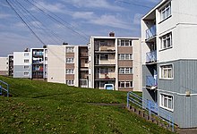
Lawrence Weston is a post-war housing estate in northwest Bristol, England, between Henbury and Shirehampton. The estate is bounded in the east by the Blaise Castle estate and woods. It is at the edge of the Severn flood plain, directly beneath the wooded Kingsweston Hill. The industrial complex and port of Avonmouth is a mile or so west, across the flood plain. Lawrence Weston forms part of the electoral ward of Avonmouth and Lawrence Weston.
Lawrence Weston was originally a hamlet, a tything of the parish of Henbury.[1] It was transformed in the late 1940s and early 1950s, when the estate was built, absorbing both the original hamlet and the neighbouring hamlet of Kings Weston. Originally council owned, much of the housing stock is now in private hands.
There are two youth centres, a BMX track, a young people's shop called Juicy Blitz and a Youth Inclusion project. It has a community farm and a range of clubs and groups for young people.
Kings Weston House and Kings Weston Roman Villa both lie near the western end of the estate.
Lawrence Weston Moor
Lawrence Weston Moor is an 11.9 hectare local nature reserve leased from Bristol City Council and managed by the Avon Wildlife Trust. The drier fields are hay meadows where plants such as meadowsweet and pepper-saxifrage are common. The wetter meadows have ragged robin, marsh marigold and creeping forget-me-not. The fields and old pollarded willows support birds such as reed buntings, snipe, reed and sedge warblers, little owls and kestrels. The rhynes (drainage ditches) are rich in water plants and provide homes for common frogs and many insects, such as dragonflies.[2][3][4]
See also
References
- ^ Extract from National Gazetteer, 1868
- ^ "Lawrence Weston Moor". Reserves. Avon Wildlife Trust. Retrieved 19 December 2010.
- ^ "Lawrence Western Moor". Local Nature Reserves. Natural England. Retrieved 4 August 2013.
- ^ "Map of Lawrence Western Moor". Local Nature Reserves. Natural England. Retrieved 4 August 2013.
- v
- t
- e
- Bristol Central
- Bristol East
- Bristol North East
- Bristol North West
- Bristol South
- Ashley
- Avonmouth and Lawrence Weston
- Bedminster
- Bishopston and Ashley Down
- Bishopsworth
- Brislington East
- Brislington West
- Central
- Clifton
- Clifton Down
- Cotham
- Easton
- Eastville
- Filwood
- Frome Vale
- Hartcliffe and Withywood
- Henbury and Brentry
- Hengrove and Whitchurch Park
- Hillfields
- Horfield
- Hotwells and Harbourside
- Knowle
- Lawrence Hill
- Lockleaze
- Redland
- Southmead
- Southville
- St George Central
- St George Troopers Hill
- St George West
- Stockwood
- Stoke Bishop
- Westbury-on-Trym and Henleaze
- Windmill Hill
- City centre
- Arnos Vale
- Ashley Down
- Ashton Gate
- Ashton Vale
- Avonmouth
- Baptist Mills
- Barton Hill
- Bedminster
- Bedminster Down
- Bishopston
- Bishopsworth
- Blaise Hamlet
- Bower Ashton
- Brentry
- Brislington
- Broadmead
- Broom Hill near Brislington
- Broomhill near Fishponds
- Canon's Marsh
- Chester Park
- Chittening
- Clifton
- Cliftonwood
- Coombe Dingle
- Cotham
- Crew's Hole
- Crofts End
- Easton
- Eastville
- Filwood Park
- Fishponds
- Golden Hill
- Greenbank
- Hartcliffe
- Headley Park
- Henbury
- Hengrove
- Henleaze
- Hillfields
- Horfield
- Hotwells
- Kensington Park
- Kingsdown
- Knowle
- Knowle West
- Lawrence Hill
- Lawrence Weston
- Lockleaze
- Lodge Hill
- Mayfield Park
- Monks Park
- Montpelier
- Old City
- Redcliffe
- Redfield
- Redland
- Sea Mills
- Shirehampton
- Sneyd Park
- Southmead
- Southville
- Speedwell
- Spike Island
- St Andrew's
- St Anne's
- St. George
- St. Jude's
- St. Paul's
- St Philip's Marsh
- St. Werburgh's
- Stapleton
- Stockwood
- Stoke Bishop
- Totterdown
- Tyndall's Park
- Upper Knowle
- Westbury-on-Trym
- Westbury Park
- Whitehall
- Windmill Hill
- Withywood
The following suburbs are in the same urban area, but lie in South Gloucestershire or North Somerset:
 | This Bristol location article is a stub. You can help Wikipedia by expanding it. |
- v
- t
- e


