Lempa River
River that flows through Guatemala, El Salvador and Honduras
14°41′33″N 89°18′18″W / 14.69250°N 89.30500°W / 14.69250; -89.30500 • location
• coordinates
• elevation
The Lempa River (Spanish: Río Lempa) is a 422-kilometre-long (262 mi) river in Central America.[2]
Geography
Its sources are located in between the Sierra Madre and the Sierra del Merendón mountain ranges in southern Guatemala, near the town of Olopa.[2] In Guatemala, the river is called Río Olopa and flows southwards for 30.4 kilometres (18.9 mi) before entering Honduras and changing its name to Lempa River at 14°32′52″N 89°15′50″W / 14.547700°N 89.264002°W / 14.547700; -89.264002. In Honduras, it flows through Ocotepeque Department for 31.4 kilometres (19.5 mi), and crosses the border with El Salvador at the town of Citalá (14°22′19″N 89°12′45″W / 14.371857°N 89.212439°W / 14.371857; -89.212439) in the department of Chalatenango. The river continues its course for another 360 kilometres (220 mi) in El Salvador, flowing in a generally southwards direction until it reaches the Pacific Ocean in the department of San Vicente.[2][3] The river forms a small part of the international boundary between El Salvador and Honduras.
The river's watershed covers 18,246 km2 (7,045 sq ml) of which 10,255 km2 (3,959 sq ml), of which 56.56% lie in El Salvador, 5,696 km2 (2,199 sq ml) in Honduras and 2,295 km2 (886 sq ml) in Guatemala.[1] Forty-nine percent of El Salvador's territory is covered by the Lempa river basin,[1] and 77.5 percent of the Salvadoran population lives in cities, towns, and villages that are in its basin, including the capital city of San Salvador.[3]
Hydroelectricity
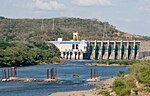
There are several hydroelectric dams along the river. In El Salvador, there is the Guayojo dam, the Cerrón Grande Hydroelectric Dam, the 5 de Noviembre dam, and the 15 de Septiembre dam, which can be easily seen from the Pan-American highway.
See also
- List of rivers of Guatemala
- List of rivers of Honduras
- List of rivers of El Salvador
- List of rivers of the Americas by coastline
References
- ^ a b c "Water Resources Assessment of El Salvador" (PDF). United States Army Corps of Engineers (USACE). 1998. Archived from the original (pdf) on 2009-01-09. Retrieved 2009-05-04.
- ^ a b c Hernández, Walter (2005). "Nacimiento y Desarrollo del río Lempa" (pdf). San Salvador: Servicio Nacional de Estudios Territoriales (SNET). Retrieved 2009-05-03.
- ^ a b "Mapas de Recursos Hídricos". San Salvador: Servicio Nacional de Estudios Territoriales (SNET). Archived from the original on April 22, 2009. Retrieved 2009-05-03.
| Authority control databases |
|
|---|


