Letterklip
30°33′20″S 17°58′33″E / 30.55556°S 17.97583°E / -30.55556; 17.97583
 South Africa
the public
- v
- t
- e
Second Boer War
- Kraaipan
- Mafeking
- Kimberley
- Talana Hill
- Elandslaagte
- 1st Ladysmith
- 2nd Ladysmith
- Chieveley
- Willow Grange
- Belmont
- Graspan
- Modder River
- Stormberg
- Magersfontein
- Colenso
- Spion Kop
- Vaal Krantz
- Paardeberg
- Bloody Sunday
- Tugela Heights
- 3rd Ladysmith
- Poplar Grove
- Driefontein
- Sanna's Post
- Boshof
- Pretoria Offensive
- Doornkop
- Faber's Put
- Diamond Hill
- Witpoort
- 1st Elands River
- Bergendal
- Bothaville
- Rhenosterkop
- Leliefontein
- Nooitgedacht
- Helvetia
- Middelfontein
- Hartbeesfontein
- Groenkloof
- Duivelskloof
- 2nd Elands River
- Blood River Poort
- Bakenlaagte
- Groenkop
- Tweebosch
- Hart's River
- Rooiwal
The Letterklip, Afrikaans for "lettered rock", is a provincial heritage site in Namaqualand in the Northern Cape province of South Africa. The unique rock formation was fortified by dry stone walling; it was occupied from 1901 to 1902 by British forces during the Anglo-Boer War. Various regimental badges and officers' names are engraved in the rockface.[1]
History
In 1980, it was described in the Government Gazette of South Africa:
This unique rock formation was fortified and occupied from 1901 to 1902 by the British forces during the Anglo-Boer War. Various regimental badges and officers' names are engraved in the rockface.
-
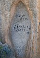 Engravings on the rocks

See also
 South Africa portal

- List of Castles and Fortifications in South Africa
- Military history of South Africa
- List of castles in Africa
- History of South Africa
- List of castles
- List of forts
- Second Boer War
- List of heritage sites in Northern Cape
References
- ^ "SAHRA - Home Page". Archived from the original on 31 December 2008. Retrieved 31 December 2008. South African Heritage Resource Agency database
- South African Heritage Resource Agency database
 | This Northern Cape location article is a stub. You can help Wikipedia by expanding it. |
- v
- t
- e


