Lime Point Light
Lighthouse in California, United States
Lighthouse
37°49′32″N 122°28′42″W / 37.825447°N 122.478321°W / 37.825447; -122.4783211900 (first)
post with beacon (current)
F W (first)
Lime Point Lighthouse is a lighthouse in California, on the northern side of the narrowest part of Golden Gate strait.[1][2] The lighthouse sits at the base of a steep cliff, very near the North anchorage of the Golden Gate Bridge. It is built on a 100-foot (30 m) long rock spur named Lime Point.
History

The brick structure for the Lime Point Lighthouse was built in 1883[3] as a fog-bell signaling station. It was eventually fitted with coal powered 12-inch (300 mm) steam whistles. During operation, the facility included the fog signal building, a coal shed, water tank and a two-story keeper's quarters. The keeper's building was later upgraded to include a third floor.[4]
In 1900, a lens lantern was hung on the south-east corner of the fog signal building, at a height of 20 feet (6.1 m) above the water. In 1902, the coal-powered steam horn was modified to use crude oil to reduce operating costs and smoke pollution.[4]
On June 3, 1960, the cargo ship India Bear rammed the lighthouse station in heavy fog.[5] The ship's captain only realized at the last minute that the India Bear was about 180 meters off course. Despite an immediate reverse maneuver initiated, the bow of the ship ran aground on the ledge. The Lime Point Light Station sustained $7,500 in damage (most notably the facility's toilet was completely destroyed) in the accident, while damage to the freighter was $60,000.[6] A subsequent investigation into the incident identified high winds, which rendered the foghorn signal ineffective, and currents in the strait as causes of the accident.
Lime Point Lighthouse continued to operate after the completion of the Golden Gate Bridge since it remained an effective position for a light and fog horn, even though Fort Point Light, at the South end of the bridge was decommissioned. Lime Point was automated by the United States Coast Guard in 1961, and the three-story dwelling and other buildings were torn down, leaving only the fog signal building, which remains.[4]
Gallery
-
 Side view of Lime Point Light
 -
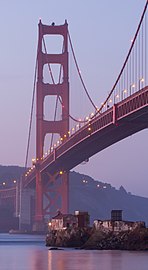 Lime Point Light with Golden Gate Bridge in the background
 -
 The freighter India Bear after ramming Lime Point Light in June 1960


See also
 California portal
 Engineering portal

References
- ^ Rowlett, Russ. "Lighthouses of the United States: Northern California". The Lighthouse Directory. University of North Carolina at Chapel Hill. Retrieved 2016-06-10.
- ^ California Historic Light Station Information & Photography United States Coast Guard. Retrieved 10 June 2016
- ^ "Marin County Points of Interest". noehill.com. NoeHill. Retrieved 7 December 2017.
- ^ a b c "Lime Point Lighthouse". LighthouseFriends. Lighthousefriends.com. Retrieved 7 December 2017.
- ^ Shanks / Shanks, Guardians of the Golden Gate, S. 157f.
- ^ Shanks / Shanks, Guardians of the Golden Gate, S. 158.
External links
- Lime Point Lighthouse Page at www.us-lighthouses.com
- U.S. Geological Survey Geographic Names Information System: Lime Point Lighthouse
Wikimedia Commons has media related to Lime Point Light.
- v
- t
- e
Lighthouses of California
- Alcatraz Island
- Anacapa Island
- Ballast Point
- Battery Point
- Cape Mendocino
- Carquinez Strait
- East Brother Island
- Farallon Island
- Fort Point
- Humboldt Harbor
- Lime Point
- Long Beach
- Los Angeles Harbor
- Mare Island
- Mile Rocks
- Oakland Harbor
- Piedras Blancas
- Pigeon Point
- Point Arena
- Point Arguello
- Point Blunt
- Point Bonita
- Point Cabrillo
- Point Conception
- Point Diablo
- Point Fermin
- Point Hueneme
- Point Loma (new)
- Point Loma (old)
- Point Montara
- Point Pinos
- Point Reyes
- Point San Luis
- Point Sur
- Point Vicente
- Punta Gorda
- Roe Island
- Rubicon Point
- Santa Barbara
- Santa Cruz Light
- Santa Cruz Breakwater
- Southampton Shoal
- St. George Reef
- Sugar Pine Point
- Table Bluff
- Trinidad Head
- Yerba Buena

 California portal
| Authority control databases: Geographic |
|
|---|
This article relating to a United States lighthouse is a stub. You can help Wikipedia by expanding it. |
- v
- t
- e
This Marin County, California building and structure-related article is a stub. You can help Wikipedia by expanding it. |
- v
- t
- e


