List of Monuments of National Importance in Andhra Pradesh
This is a list of Monuments of National Importance officially recognized by and available through the website of the Archaeological Survey of India (ASI) in the Indian state Andhra Pradesh.[1][2] The monument identifier is a combination of the abbreviation of the subdivision of the list (state, ASI circle) and the numbering as published on the website of the ASI. As of August 2021[update], there are 135 Monuments of National Importance in Andhra Pradesh.[3]
List of monuments of national importance
| SL. No. | Description | Location | Address | District | Coordinates | Image |
|---|---|---|---|---|---|---|
| N-AP-1 | Hill Fort and buildings therein and the fortifications at the foot of the hill | Gooty | Anantapur | 15°07′N 77°38′E / 15.12°N 77.63°E / 15.12; 77.63 (SL. No. N-AP-1) |   | |
| N-AP-2 | Madhavaraya temple (old Vishnu temple) | Gorantla | Sri Sathya Sai | 13°59′03″N 77°46′01″E / 13.9841531°N 77.7670462°E / 13.9841531; 77.7670462 (SL. No. N-AP-2) |  Upload Photo | |
| N-AP-3 | Outer wall of the Mahalakshmi temple | Gorripalli | Sri Sathya Sai | 13°51′13″N 77°27′10″E / 13.8535994°N 77.4527828°E / 13.8535994; 77.4527828 (SL. No. N-AP-3) | Upload Photo | |
| N-AP-4 | Group of sculptures – Ancient Site | Hemavati | Sri Sathya Sai | 14°01′39″N 76°59′46″E / 14.0274533°N 76.9960673°E / 14.0274533; 76.9960673 (SL. No. N-AP-4) | Upload Photo | |
| N-AP-5 | Group of old temples together with adjacent land | Hemavati | Sri Sathya Sai | 14°01′38″N 76°59′44″E / 14.0272637°N 76.9955037°E / 14.0272637; 76.9955037 (SL. No. N-AP-5) | Upload Photo | |
| N-AP-6 | Large dolmen on a rocky hillock | Kalyandurg | Anantapur | 14°34′15″N 77°07′34″E / 14.5708670°N 77.1261109°E / 14.5708670; 77.1261109 (SL. No. N-AP-6) | 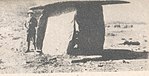 | |
| N-AP-7 | Sri Kamala Malleswara Swamy Temple, Mallikarjuna (Siva) temple | Kambaduru | Anantapur | 14°21′05″N 77°13′59″E / 14.3515084°N 77.2331380°E / 14.3515084; 77.2331380 (SL. No. N-AP-7) | Upload Photo | |
| N-AP-8 | Virabhadra temple | Lepakshi | Sri Sathya Sai | 13°48′07″N 77°36′34″E / 13.8018218°N 77.6094878°E / 13.8018218; 77.6094878 (SL. No. N-AP-8) |  | |
| N-AP-9 | Basavannah temple | Lepakshi | Sri Sathya Sai | 13°48′12″N 77°36′45″E / 13.8033059°N 77.6124547°E / 13.8033059; 77.6124547 (SL. No. N-AP-9) |  | |
| N-AP-10 | Hill fort | Madakasira | Sri Sathya Sai | 13°56′38″N 77°16′07″E / 13.9440268°N 77.2687232°E / 13.9440268; 77.2687232 (SL. No. N-AP-10) | 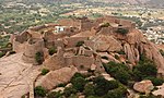 | |
| N-AP-11 | Large bastion and an old gateway | Madakasira | Sri Sathya Sai | 13°56′23″N 77°16′10″E / 13.9396603°N 77.2695299°E / 13.9396603; 77.2695299 (SL. No. N-AP-11) | 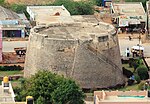 | |
| N-AP-12 | Old gopuram | Penukonda | Sri Sathya Sai | 14°04′08″N 77°34′56″E / 14.0687580°N 77.5822483°E / 14.0687580; 77.5822483 (SL. No. N-AP-12) | Upload Photo | |
| N-AP-13 | Old stamba or lamp pillar in the sub collector's office compound | Penukonda | Sri Sathya Sai | 14°05′15″N 77°35′45″E / 14.0875337°N 77.5957238°E / 14.0875337; 77.5957238 (SL. No. N-AP-13) | Upload Photo | |
| N-AP-14 | Seethatheertham stepped well with entrance in the form of a bull | Penukonda | Sri Sathya Sai | 14°04′46″N 77°35′44″E / 14.0795283°N 77.5956862°E / 14.0795283; 77.5956862 (SL. No. N-AP-14) | 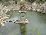 | |
| N-AP-15 | Small pavilion and ruined water tower in a field | Penukonda | Sri Sathya Sai | 14°04′39″N 77°35′46″E / 14.0774327°N 77.5959846°E / 14.0774327; 77.5959846 (SL. No. N-AP-15) | Upload Photo | |
| N-AP-16 | The citadel and ruined buildings on the hill | Penukonda | Sri Sathya Sai | 14°04′39″N 77°35′11″E / 14.0774025°N 77.5864993°E / 14.0774025; 77.5864993 (SL. No. N-AP-16) | Upload Photo | |
| N-AP-17 | The Hill fort and northern gateway with inscriptions | Penukonda | Sri Sathya Sai | 14°05′05″N 77°35′42″E / 14.0847871°N 77.5951253°E / 14.0847871; 77.5951253 (SL. No. N-AP-17) |  | |
| N-AP-18 | Watch tower known as Rama's bastion | Penukonda | Sri Sathya Sai | 14°05′08″N 77°35′30″E / 14.0856437°N 77.5915683°E / 14.0856437; 77.5915683 (SL. No. N-AP-18) | Upload Photo | |
| N-AP-19 | Hill fortress and a large well | Ratnagiri | Sri Sathya Sai | 13°48′57″N 77°07′34″E / 13.8157657°N 77.1259935°E / 13.8157657; 77.1259935 (SL. No. N-AP-19) |  | |
| N-AP-20 | Extensive hill-fortress with outlying fortification excluding the fort gate | Rayadurg | Anantapur | 14°42′24″N 76°50′24″E / 14.7066440°N 76.8400311°E / 14.7066440; 76.8400311 (SL. No. N-AP-20) | Upload Photo | |
| N-AP-21 | Palace and two temples of Rama and Krishna | Rayadurg | Anantapur | 14°42′10″N 76°50′12″E / 14.7026623°N 76.8367706°E / 14.7026623; 76.8367706 (SL. No. N-AP-21) | Upload Photo | |
| N-AP-22 | Chintala Venkataramana Temple | Tadipatri | Anantapur | 14°54′40″N 78°00′38″E / 14.9110644°N 78.0104851°E / 14.9110644; 78.0104851 (SL. No. N-AP-22) |  | |
| N-AP-23 | Rameswaraswami temple | Tadipatri | Anantapur | 14°55′05″N 78°00′37″E / 14.9181729°N 78.0101478°E / 14.9181729; 78.0101478 (SL. No. N-AP-23) | 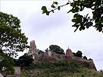 | |
| N-AP-24 | Lower Fort and structure | Chandragiri | Tirupati | 13°34′57″N 79°18′18″E / 13.5825642°N 79.3049343°E / 13.5825642; 79.3049343 (SL. No. N-AP-24) | 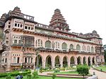 | |
| N-AP-25 | Upper Fort | Chandragiri | Tirupati | 13°35′15″N 79°17′41″E / 13.5875547°N 79.2945917°E / 13.5875547; 79.2945917 (SL. No. N-AP-25) |  | |
| N-AP-26 | Parasuramesvara temple | Gudimallam, Tirupati | Tirupati | 13°36′13″N 79°34′39″E / 13.6035812°N 79.5774769°E / 13.6035812; 79.5774769 (SL. No. N-AP-26) |  | |
| N-AP-27 | Fort | Gurramkonda | Annamayya | 13°46′17″N 78°35′18″E / 13.7713841°N 78.5884707°E / 13.7713841; 78.5884707 (SL. No. N-AP-27) |  | |
| N-AP-28 | Lower Fort, Center Fort wall, moat, old fort gateway, old hanuman temple, old mandapam | Gurramkonda | Annamayya | 13°46′32″N 78°35′10″E / 13.7754761°N 78.5859933°E / 13.7754761; 78.5859933 (SL. No. N-AP-28) | Upload Photo | |
| N-AP-29 | Mahal | Gurramkonda | Annamayya | 13°46′36″N 78°35′11″E / 13.7767994°N 78.5862833°E / 13.7767994; 78.5862833 (SL. No. N-AP-29) |  | |
| N-AP-30 | Palliswara Mudaiya Madeya temple | Kalakada | Annamayya | 13°50′N 78°47′E / 13.83°N 78.78°E / 13.83; 78.78 (SL. No. N-AP-30) | Upload Photo | |
| N-AP-31 | Venkateswara Vishnu temple | Mangapuram, Tirupati | Tirupati | 13°36′39″N 79°19′39″E / 13.6108923°N 79.3275775°E / 13.6108923; 79.3275775 (SL. No. N-AP-31) | 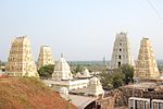 | |
| N-AP-32 | Megalithic cairns with bounding stone circles | Pandur | Chittoor | Upload Photo | ||
| N-AP-33 | Chennakeswaraswami temple | Sompalle | Annamayya | 13°50′13″N 78°17′53″E / 13.8370766°N 78.2979495°E / 13.8370766; 78.2979495 (SL. No. N-AP-33) |  More images | |
| N-AP-34 | Megalithic cists and cairns | Virakuppam (Birakuppam) | Chittoor | Upload Photo | ||
| N-AP-35 | Mounds containing Buddhist remains such as stupas | Adurru | Konaseema | 16°28′43″N 81°57′18″E / 16.4785590°N 81.9549836°E / 16.4785590; 81.9549836 (SL. No. N-AP-35) |  | |
| N-AP-36 | Gollingeswara group of temples | Biccavolu | East Godavari | 16°57′34″N 82°02′55″E / 16.9594830°N 82.0486661°E / 16.9594830; 82.0486661 (SL. No. N-AP-36) | 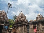 More images | |
| N-AP-37 | Kanchragudi | Biccavolu | East Godavari | 16°57′34″N 82°03′13″E / 16.9594660°N 82.0536711°E / 16.9594660; 82.0536711 (SL. No. N-AP-37) |  | |
| N-AP-38 | Monolithic Ganesa Image | Biccavolu | East Godavari | 16°57′42″N 82°03′14″E / 16.9615345°N 82.0537687°E / 16.9615345; 82.0537687 (SL. No. N-AP-38) |  | |
| N-AP-39 | Nakkalagudi | Biccavolu | East Godavari | 16°57′22″N 82°02′54″E / 16.9561439°N 82.0484308°E / 16.9561439; 82.0484308 (SL. No. N-AP-39) |  | |
| N-AP-40 | Veerabhadra temple | Biccavolu | East Godavari | 16°57′43″N 82°03′07″E / 16.9620113°N 82.0519076°E / 16.9620113; 82.0519076 (SL. No. N-AP-40) | 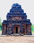 | |
| N-AP-41 | Bhimeswara temple | Draksharama | Konaseema | 16°47′35″N 82°03′49″E / 16.7929599°N 82.0636104°E / 16.7929599; 82.0636104 (SL. No. N-AP-41) |  | |
| N-AP-42 | Rock-cut caves, cisterns and remains of Buddhist monasteries, Stupas on the hill pandavulakonda or pandavakonda | Kapavaram | East Godavari | 17°10′05″N 81°48′44″E / 17.1680890°N 81.8123280°E / 17.1680890; 81.8123280 (SL. No. N-AP-42) | 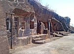 More images | |
| N-AP-43 | Buddhist remains at Kodavali | Kodavali | Kakinada | 17°14′26″N 82°16′20″E / 17.2406625°N 82.2723567°E / 17.2406625; 82.2723567 (SL. No. N-AP-43) |  | |
| N-AP-44 | Kumara Bhimeswara temple | Samalkota | Kakinada | 17°02′32″N 82°10′17″E / 17.0423202°N 82.1714362°E / 17.0423202; 82.1714362 (SL. No. N-AP-44) |  More images | |
| N-AP-45 | Ruined Buddhist stupa and other remains | Amaravati | Palnadu | 16°34′33″N 80°21′25″E / 16.5757281°N 80.3568088°E / 16.5757281; 80.3568088 (SL. No. N-AP-45) |  | |
| N-AP-46 | Ancient Siva temple with inscription | Ayyangaripalam (Hamlet of Pondugula) | Palnadu | 16°38′16″N 79°39′09″E / 16.637868°N 79.652559°E / 16.637868; 79.652559 (SL. No. N-AP-46) | Upload Photo | |
| N-AP-47 | Sri Bhavanarayanaswami temple | Bapatla | Bapalta | 15°54′21″N 80°28′04″E / 15.905912°N 80.467719°E / 15.905912; 80.467719 (SL. No. N-AP-47) | Upload Photo | |
| N-AP-48 | Ruined Buddhist stupa | Bhattiprolu | Bapalta | 16°06′N 80°47′E / 16.1°N 80.78°E / 16.1; 80.78 (SL. No. N-AP-48) |  | |
| N-AP-49 | The Sculptures, carvings, images or other like objects discovered within the revenue limit | Buddam | Bapalta | Upload Photo | ||
| N-AP-50 | Kapoteswara temple with the inscriptional monuments within the temple site(slabs in the temple site) | Chejerla | Palnadu | 16°18′59″N 79°50′58″E / 16.316389°N 79.849444°E / 16.316389; 79.849444 (SL. No. N-AP-50) |  | |
| N-AP-51 | Inscribed rock to the west of Dharanikota | Amaravati | Palnadu | Upload Photo | ||
| N-AP-52 | Fort in ruins | Dharanikota | Palnadu | Upload Photo | ||
| N-AP-53 | Mounds with ancient remains on them | Grandhasiri | Palnadu | 16°34′36″N 80°09′08″E / 16.576667°N 80.152222°E / 16.576667; 80.152222 (SL. No. N-AP-53) |  More images | |
| N-AP-54 | Inscribed marble pillar near the Gopala temple | Ipuru | Palnadu | Upload Photo | ||
| N-AP-55 | Ancient Buddhist remains and Brahmi inscriptions on the mound | Manchikallu | Palnadu | Upload Photo | ||
| N-AP-56 | Reconstructed monuments at Anupu and Nagarjunklonda hilltop | Nagarjunakonda | Palnadu | 16°30′13″N 79°16′35″E / 16.5037152°N 79.2764221°E / 16.5037152; 79.2764221 (SL. No. N-AP-56) | Upload Photo | |
| N-AP-57 | Mounds within the limit of Nagulavaram | Nagulavaram | Palnadu | Upload Photo | ||
| N-AP-58 | The Sculptures, carvings, images on the ancient mound | Pullareddigudem | Palnadu | Upload Photo | ||
| N-AP-59 | 1. The mounds with remains of ancient building between the hillock of Nagarjuna Konda and the village of Pullareddigudem, 2. Mounds adjacent to the hillock reddigudem, 3. Hill of Nagarjunakonda with the ancient remains | Pullareddigudem (Agarharam) | Palnadu |  | ||
| N-AP-60 | Fort-storeyed rock-cut Hindu temple | Undavalli | Guntur District | 16°29′49″N 80°34′54″E / 16.49687°N 80.58178°E / 16.49687; 80.58178 (SL. No. N-AP-60) |  | |
| N-AP-61 | Mounds with ancient remains | Velpur | Palnadu | 16°34′48″N 80°07′39″E / 16.5800395°N 80.1273985°E / 16.5800395; 80.1273985 (SL. No. N-AP-61) | 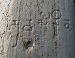 | |
| N-AP-62 | Vigneswara swamy temple | Chilamakuru | Kadapa YSR | 14°38′44″N 78°28′13″E / 14.6454334°N 78.4703878°E / 14.6454334; 78.4703878 (SL. No. N-AP-62) | Upload Photo | |
| N-AP-63 | Agastheswar Swamy Temple | Chilamkur | Kadapa YSR | 14°38′44″N 78°28′13″E / 14.6454334°N 78.4703878°E / 14.6454334; 78.4703878 (SL. No. N-AP-63) | Upload Photo | |
| N-AP-64 | Remains of the buried Jain temple | Daanavulapadu | Kadapa YSR | 14°47′13″N 78°26′18″E / 14.7868263°N 78.4383739°E / 14.7868263; 78.4383739 (SL. No. N-AP-64) | Upload Photo | |
| N-AP-65 | Fort with enclosed ancient buildings, Madhavaperumal temple and tower known as Madarsala | Gandikota | Kadapa YSR | 14°48′47″N 78°17′04″E / 14.8130856°N 78.2845110°E / 14.8130856; 78.2845110 (SL. No. N-AP-65) | 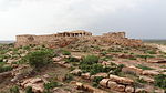 More images | |
| N-AP-66 | Saumyanatha temple | Nandalur | Annamayya | 14°16′03″N 79°07′14″E / 14.2675749°N 79.1206246°E / 14.2675749; 79.1206246 (SL. No. N-AP-66) |  | |
| N-AP-67 | Ancient Village sites | Peddamudiyam | Kadapa YSR | Upload Photo | ||
| N-AP-68 | Kothandaramaswami Temple | Peddamudiyam | Kadapa YSR | Upload Photo | ||
| N-AP-69 | Mukundesvara temple with inscriptions | Peddamudiyam | Kadapa YSR | 15°00′51″N 78°26′59″E / 15.0142581°N 78.4497539°E / 15.0142581; 78.4497539 (SL. No. N-AP-69) | Upload Photo | |
| N-AP-70 | Narasimha temple | Peddamudiyam | Kadapa YSR | 15°00′46″N 78°26′55″E / 15.0127344°N 78.4487179°E / 15.0127344; 78.4487179 (SL. No. N-AP-70) | Upload Photo | |
| N-AP-71 | Old Vishnu temples with inscriptions | Peddanudiyam | Kadapa YSR | 15°00′51″N 78°26′59″E / 15.0142581°N 78.4497539°E / 15.0142581; 78.4497539 (SL. No. N-AP-71) | Upload Photo | |
| N-AP-72 | Athirala Parasurama temple | Poli | Annamayya | 14°14′39″N 79°09′49″E / 14.244128°N 79.163709°E / 14.244128; 79.163709 (SL. No. N-AP-72) | Upload Photo | |
| N-AP-73 | Bheemeshwara swami temple | Pushpagiri (hamlet of Kotluru) | Kadapa YSR | 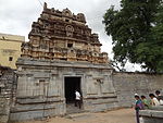 | ||
| N-AP-74 | Indranadheshwara swami temple | Pushpagiri (hamlet of Kotluru) | Kadapa YSR | 14°36′05″N 78°45′22″E / 14.6015196°N 78.7562449°E / 14.6015196; 78.7562449 (SL. No. N-AP-74) |  | |
| N-AP-75 | Kamalasambheshwara swamy temple | Pushpagiri (hamlet of Kotluru) | Kadapa YSR | 14°35′42″N 78°45′39″E / 14.5950546°N 78.7608053°E / 14.5950546; 78.7608053 (SL. No. N-AP-75) | Upload Photo | |
| N-AP-76 | Raghaveswara swamy temple | Pushpagiri (hamlet of Kotluru) | Kadapa YSR | Upload Photo | ||
| N-AP-77 | Sivakesavaswami temple | Pushpagiri (hamlet of Kotluru) | Kadapa YSR | 14°35′40″N 78°45′38″E / 14.5945579°N 78.7606142°E / 14.5945579; 78.7606142 (SL. No. N-AP-77) | Upload Photo | |
| N-AP-78 | Trikoteswara swami temple | Pushpagiri (hamlet of Kotluru) | Kadapa YSR | 14°35′44″N 78°45′25″E / 14.5956026°N 78.7568175°E / 14.5956026; 78.7568175 (SL. No. N-AP-78) | Upload Photo | |
| N-AP-79 | Vaidhyanadha swamy temple | Pushpagiri (hamlet of Kotluru) | Kadapa YSR | 14°35′45″N 78°45′24″E / 14.5958969°N 78.7567032°E / 14.5958969; 78.7567032 (SL. No. N-AP-79) | 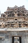 | |
| N-AP-80 | Fort with ancient buildings therein | Siddhout | Kadapa YSR | 14°27′59″N 78°58′03″E / 14.466349°N 78.96762°E / 14.466349; 78.96762 (SL. No. N-AP-80) |  | |
| N-AP-81 | Visvanatha swamy temple | Sivalpalle (Pushpagiri) | Kadapa YSR | 14°34′52″N 78°45′49″E / 14.5810957°N 78.7636876°E / 14.5810957; 78.7636876 (SL. No. N-AP-81) | Upload Photo | |
| N-AP-82 | Sri Kodandarma swamy temple and adjoining buildings | Vontimitta | Kadapa YSR | 14°23′38″N 79°01′35″E / 14.393785°N 79.026436°E / 14.393785; 79.026436 (SL. No. N-AP-82) | 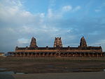 More images | |
| N-AP-83 | Ancient site with the mound marking the Buddhist Stupas in it | Alluru | NTR District | 16°46′18″N 80°26′17″E / 16.7716396°N 80.4380637°E / 16.7716396; 80.4380637 (SL. No. N-AP-83) | Upload Photo | |
| N-AP-84 | Buddhist remains in a mound | Ghantasala | Krishna | 16°10′12″N 80°56′56″E / 16.1699254°N 80.9489118°E / 16.1699254; 80.9489118 (SL. No. N-AP-84) | 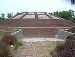 | |
| N-AP-85 | Mound containing Buddhist remains and ancient village site | Gudivada | Krishna | 16°25′56″N 81°00′11″E / 16.4323098°N 81.0031116°E / 16.4323098; 81.0031116 (SL. No. N-AP-85) | Upload Photo | |
| N-AP-86 | Sculptures, carvings, images other like objects found in the vicinity of the old Mosque | Gudur | Krishna | 16°12′54″N 81°04′56″E / 16.2151092°N 81.0823474°E / 16.2151092; 81.0823474 (SL. No. N-AP-86) | Upload Photo | |
| N-AP-87 | Hillock containing the mound marking the ancient remains of Buddhist stupas situated on it | Gummadiduru | NTR District | 16°51′41″N 80°19′04″E / 16.861382°N 80.317704°E / 16.861382; 80.317704 (SL. No. N-AP-87) | Upload Photo | |
| N-AP-88 | Buddhist remains of a Stupa on the hill | Jaggayyapeta | NTR District | 16°53′13″N 80°06′23″E / 16.887005°N 80.106482°E / 16.887005; 80.106482 (SL. No. N-AP-88) |  | |
| N-AP-89 | Bandar Fort: 1) Armoury known as Fort and customs office, Bandar Fort customs office, 2) Belfry | Masulipatnam | Krishna | 16°09′08″N 81°09′10″E / 16.1521485°N 81.1527597°E / 16.1521485; 81.1527597 (SL. No. N-AP-89) | Upload Photo | |
| N-AP-90 | Dutch cemetery (D.No. 308) | Masulipatnam | Krishna | 16°11′56″N 81°08′36″E / 16.1988233°N 81.1433022°E / 16.1988233; 81.1433022 (SL. No. N-AP-90) | Upload Photo | |
| N-AP-91 | Rock-cut cave temples on the Hill | Mogalrajapuram | NTR District | 16°30′22″N 80°38′49″E / 16.506111°N 80.646944°E / 16.506111; 80.646944 (SL. No. N-AP-91) |  | |
| N-AP-92 | Ancient site and remains comprised in survey plot No. 37 | Munagacherla | NTR District | Upload Photo | ||
| N-AP-93 | Four pillars in the ruined mandapam in Jammidoddi | Vijayawada | NTR District | 16°30′58″N 80°36′30″E / 16.5161113°N 80.6082458°E / 16.5161113; 80.6082458 (SL. No. N-AP-93) | Upload Photo | |
| N-AP-94 | Inscribed Pillar and slab in Mallesvarasvami temple | Vijayawada | NTR District | 16°30′58″N 80°36′27″E / 16.5161133°N 80.6074978°E / 16.5161133; 80.6074978 (SL. No. N-AP-94) | Upload Photo | |
| N-AP-95 | Kiratharjuna Pillar on the Indrakilla Hill | Vijayawada | NTR District | 16°30′50″N 80°36′24″E / 16.5138317°N 80.6065563°E / 16.5138317; 80.6065563 (SL. No. N-AP-95) |  | |
| N-AP-96 | Two rock-cut cave temples on the Indrakila hill known as Akkana Madanna cave | Vijayawada | NTR District | 16°30′50″N 80°36′24″E / 16.513889°N 80.606667°E / 16.513889; 80.606667 (SL. No. N-AP-96) | 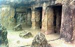 | |
| N-AP-97 | Ruined fort and buildings therein except Ramazan masjid | Adoni | Kurnool | 15°38′49″N 77°16′38″E / 15.6469651°N 77.2773130°E / 15.6469651; 77.2773130 (SL. No. N-AP-97) |  More images | |
| N-AP-98 | Inscribed boulder bearing Andhra records of 150 A.D. | Chinnakadaburu | Kurnool | Upload Photo | ||
| N-AP-99 | A prominent granite hillock bearing Asokan inscriptions | Jonnagiri | Kurnool | 15°12′36″N 77°34′38″E / 15.2100561°N 77.5773215°E / 15.2100561; 77.5773215 (SL. No. N-AP-99) |  | |
| N-AP-100 | Gateways and the bastions of the old fort, viz 1) Bastion No.1 Beach Ghantki Buruzu 2) Bastion No.2 Lal Bangalow Buruzu 3) Gateway to Gopala Darwaja 4) Gateway to Panikiddi | Kurnool | Kurnool | 15°50′02″N 78°02′55″E / 15.8337848°N 78.0486560°E / 15.8337848; 78.0486560 (SL. No. N-AP-100) | 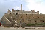 More images | |
| N-AP-101 | Mausoleum known as Abdul Wahab Khan's Tomb and adjoining buildings | Kurnool | Kurnool | 15°49′38″N 78°02′48″E / 15.8272843°N 78.0467154°E / 15.8272843; 78.0467154 (SL. No. N-AP-101) |  | |
| N-AP-102 | Nandavaram Temple including the sculpture of Subrahamanya | Nandavaram | Kurnool | 15°51′00″N 77°28′56″E / 15.8500845°N 77.4823029°E / 15.8500845; 77.4823029 (SL. No. N-AP-102) | Upload Photo | |
| N-AP-103 | The Asokan inscription, Two early Chalukya inscriptions and One late Chalukya inscriptions. | Rajulamandagiri (Hamlet of Jutur) | Kurnool | 15°26′06″N 77°28′18″E / 15.4350589°N 77.4717205°E / 15.4350589; 77.4717205 (SL. No. N-AP-103) | Upload Photo | |
| N-AP-104 | Inscribed stone lying to the east of Siva temple | Rayachoti | Kurnool | Upload Photo | ||
| N-AP-105 | Old Cave Temple | Yaganti | Nandyal | 15°21′04″N 78°08′19″E / 15.3510672°N 78.1387430°E / 15.3510672; 78.1387430 (SL. No. N-AP-105) |  | |
| N-AP-106 | Uma-Mahesvaraswami Temple | Yaganti | Nandyal | 15°21′03″N 78°08′18″E / 15.3507963°N 78.1383611°E / 15.3507963; 78.1383611 (SL. No. N-AP-106) |  | |
| N-AP-107 | Ancient Mounds | Kanuparti | Prakasam | Upload Photo | ||
| N-AP-108 | A group of eight rock-cut temples in Bhairavakonda hill | Kottapalli | Prakasam | 15°05′21″N 79°12′02″E / 15.089223°N 79.200652°E / 15.089223; 79.200652 (SL. No. N-AP-108) | Upload Photo | |
| N-AP-109 | Chola Temple | Motupalle | Prakasam | 15°43′16″N 80°17′35″E / 15.721205°N 80.293029°E / 15.721205; 80.293029 (SL. No. N-AP-109) | Upload Photo | |
| N-AP-110 | Ancient Mound | Pedaganjam | Prakasam | Upload Photo | ||
| N-AP-111 | Pitikeswara group of temples including Approach road | Pittikayagulla | Prakasam | 15°28′45″N 79°07′18″E / 15.479280°N 79.121782°E / 15.479280; 79.121782 (SL. No. N-AP-111) | Upload Photo | |
| N-AP-112 | Ancient Site | Pusalapadu | Prakasam | Upload Photo | ||
| N-AP-113 | Ramalingeswara group of temples | Satiavel (Satyavolu) | Prakasam | 15°24′11″N 78°58′49″E / 15.4031317°N 78.9803243°E / 15.4031317; 78.9803243 (SL. No. N-AP-113) | Upload Photo | |
| N-AP-114 | Mound known as 'Bodipati Dibba' | Ramatirtham (Hamlet of Varini) | SPSR Nellore | Upload Photo | ||
| N-AP-115 | Ancient Mound in part of S.No. 855 A | Ramatirtham | SPSR Nellore | Upload Photo | ||
| N-AP-116 | Hill Fort with Ancient buildings therein | Udayagiri | SPSR Nellore | 14°52′47″N 79°16′12″E / 14.8796167°N 79.2700173°E / 14.8796167; 79.2700173 (SL. No. N-AP-116) |  More images | |
| N-AP-117 | Krishna Temple in a part of Donka with Gopuram, Kalyanamandapam and Masonry built Tank | Udayagiri | SPSR Nellore | 14°51′55″N 79°16′31″E / 14.8652392°N 79.2753247°E / 14.8652392; 79.2753247 (SL. No. N-AP-117) | Upload Photo | |
| N-AP-118 | Ranganayakula Temple | Udayagiri | SPSR Nellore | 14°52′41″N 79°17′46″E / 14.877995°N 79.296235°E / 14.877995; 79.296235 (SL. No. N-AP-118) |  More images | |
| N-AP-119 | Ancient Mound | Kalingapatnam | Srikakulam | 18°19′50″N 84°06′39″E / 18.330605°N 84.110767°E / 18.330605; 84.110767 (SL. No. N-AP-119) | 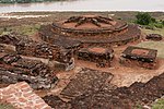 | |
| N-AP-120 | Sri Somesvara temple | Mukhalingam | Srikakulam | 18°35′30″N 83°57′53″E / 18.591637°N 83.964861°E / 18.591637; 83.964861 (SL. No. N-AP-120) |  | |
| N-AP-121 | Bhimesvara temple | Mukhalingesvara | Srikakulam | 18°35′39″N 83°57′52″E / 18.594191°N 83.964379°E / 18.594191; 83.964379 (SL. No. N-AP-121) | Upload Photo | |
| N-AP-122 | Mukhalingesvara temple | Mukhalingesvara | Srikakulam | 18°35′42″N 83°57′49″E / 18.595021°N 83.963547°E / 18.595021; 83.963547 (SL. No. N-AP-122) | 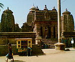 | |
| N-AP-123 | Buddhist remains: 1) Six Images 2) Three images and some more images on the hill 3) One image 4) Three images | Salihundam | Srikakulam | 18°20′02″N 84°02′34″E / 18.33387°N 84.042662°E / 18.33387; 84.042662 (SL. No. N-AP-123) | | |
| N-AP-124 | Eastern portion of Salihundam hill containing Buddhist remains (A Chaitya and four stupas) | Salihundam | Srikakulam |  | ||
| N-AP-125 | Ancient Buddhist Mounds locally known as 'Dhana Dibbalu' | Kotturu (near Gokivada forest) | Anakapalli |  More images | ||
| N-AP-126 | Buddhist rock-cut stupas, Dagabas and caves and the ruins of a structural Chaitya with its outbuilding and other Ancient remains on twoadjoining hills known as Bojjanna Konda. | Sankaram | Anakapalli | 17°42′37″N 83°00′58″E / 17.710316°N 83.016001°E / 17.710316; 83.016001 (SL. No. N-AP-126) | 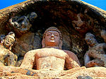 More images | |
| N-AP-127 | Durga Bhairavakonda having an ancient monument called Durga | Nilavati | Vizianagaram District | 18°10′29″N 83°19′23″E / 18.174703°N 83.322989°E / 18.174703; 83.322989 (SL. No. N-AP-127) | Upload Photo | |
| N-AP-128 | Ruined Buddhist Monastery at Gurubhaktulakonda | Ramatheertham | Vizianagaram District | 18°10′34″N 83°29′12″E / 18.1761240°N 83.4867449°E / 18.1761240; 83.4867449 (SL. No. N-AP-128) | 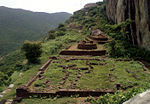 More images | |
| N-AP-129 | The old temple (Dibbesvarasvami temple) | Sarapalli (Sarapalle) | Vizianagaram | 18°08′03″N 83°28′01″E / 18.134223°N 83.467003°E / 18.134223; 83.467003 (SL. No. N-AP-129) |  More images | |
| N-AP-130 | Mounds containing Buddhist remains | Arugolanu | West Godavari | Upload Photo | ||
| N-AP-131 | Mounds locally known as Bhimalingadibba | Denduluru | Eluru | 16°45′41″N 81°09′57″E / 16.7612944°N 81.1659250°E / 16.7612944; 81.1659250 (SL. No. N-AP-131) | Upload Photo | |
| N-AP-132 | Buddhist monuments: 1) Rock-cut temple 2) Large Monastery 3) Small Monastery 4) Brick Chaitya 5) Ruined Mandapa 6) Stone built Stupa and Large group of stupas. | Guntupalli | Eluru | 17°01′12″N 81°07′50″E / 17.0199381°N 81.1306516°E / 17.0199381; 81.1306516 (SL. No. N-AP-132) |  | |
| N-AP-132-a | Buddhist monuments: 1) Rock-cut temple | Guntupalli | Eluru | 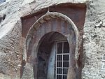 | ||
| N-AP-132-b | Buddhist monuments: 2) Large Monastery | Guntupalli | Eluru |  | ||
| N-AP-132-c | Buddhist monuments: 3) Small Monastery | Guntupalli | Eluru |  | ||
| N-AP-132-d | Buddhist monuments: 4) Brick Chaitya | Guntupalli | Eluru |  | ||
| N-AP-132-e | Buddhist monuments: 5) Ruined Mandapa | Guntupalli | Eluru | 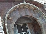 | ||
| N-AP-132-f | Buddhist monuments: 6) Stone built Stupa and Large group of stupas. | Guntupalli | Eluru | | ||
| N-AP-133 | The caves and structural stupa of Archaeological interest on Dharmalingesvarasvami hill | Jilakarragudem (Hamlet of Guntupalli) | Eluru |  | ||
| N-AP-134 | Ancient Mounds in S.No. 501-1 | Pedavegi | Eluru | 16°48′51″N 81°06′23″E / 16.8140396°N 81.1063484°E / 16.8140396; 81.1063484 (SL. No. N-AP-134) |  | |
| N-AP-135 | The mounds of Pedavegi : Dibba No.1 Dibba No.2, Dibba No. 3, Dibba No. 4, Dibba No. 5. | Pedavegi | Eluru |  |
See also
- List of Monuments of National Importance in India for other Monuments of National Importance in India
- List of State Protected Monuments in Andhra Pradesh
- List of Monuments of National Importance in Telangana (a state formed in 2014)
Notes and references
- ^ List of Monuments of National Importance as published by the Archaeological Survey of India Archived 27 June 2014 at the Wayback Machine.
- ^ "ASI Hyderabad Circle". Archived from the original on 5 January 2015. Retrieved 16 February 2015.
- ^ "Alphabetical List of Monuments – Andhra Pradesh « Archaeological Survey of India". asi.nic.in. Retrieved 11 May 2023.
Wikimedia Commons has media related to Monuments of National Importance in Andhra Pradesh.
- v
- t
- e
Monuments in India
Importance
| States | |
|---|---|
| Union territories |
Protected
| States | |
|---|---|
| Union territories |


