List of historic places in Central Ontario
This is a list of historic places in Central Ontario, containing heritage sites listed on the Canadian Register of Historic Places (CRHP), all of which are designated as historic places either locally, provincially, territorially, nationally, or by more than one level of government.
Map all coordinates using OpenStreetMap
Download coordinates as:
- KML
- GPX (all coordinates)
- GPX (primary coordinates)
- GPX (secondary coordinates)
List of historic places
Dufferin County
| Name | Address | Coordinates | Government recognition (CRHP №) | Image | |
|---|---|---|---|---|---|
| Dufferin County Court House | 51 Zina Street Orangeville ON | 43°55′21″N 80°39′48″W / 43.9224°N 80.6633°W / 43.9224; -80.6633 (Dufferin County Court House) | Ontario (10426) | 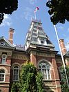 More images |
Haliburton County
| Name | Address | Coordinates | Government recognition (CRHP №) | Image | |
|---|---|---|---|---|---|
| Wilberforce Red Cross Outpost National Historic Site of Canada | 2314 Loop Road (Highway 648) Highlands East ON | 45°02′17″N 78°13′24″W / 45.038°N 78.2232°W / 45.038; -78.2232 (Wilberforce Red Cross Outpost National Historic Site of Canada) | Federal (7740) | 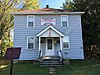 |
Hastings County
| Name | Address | Coordinates | Government recognition (CRHP №) | Image | |
|---|---|---|---|---|---|
| Armoury | Bridge and Pinnacle Streets Belleville ON | 44°09′49″N 77°22′54″W / 44.1637°N 77.3818°W / 44.1637; -77.3818 (Armoury) | Federal (9706) |  More images | |
| Belleville Railway Station (Grand Trunk) National Historic Site of Canada | 240 Station Street Belleville ON | 44°10′44″N 77°22′27″W / 44.1789°N 77.3741°W / 44.1789; -77.3741 (Belleville Railway Station (Grand Trunk) National Historic Site of Canada) | Federal (7368, (4552) | 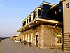 More images | |
| Government of Canada Building | 11 Station Street Belleville ON | 44°10′12″N 77°23′05″W / 44.1701°N 77.3846°W / 44.1701; -77.3846 (Government of Canada Building) | Federal (16123) |  Upload Photo | |
| Bellevue Terrace | 10 Patterson Street Belleville ON | 44°09′59″N 77°23′00″W / 44.1663°N 77.3832°W / 44.1663; -77.3832 (Bellevue Terrace) | Ontario (6302) | Upload Photo | |
| Glanmore / Phillips-Faulkner House National Historic Site of Canada | 257 Bridge Street East Belleville ON | 44°06′00″N 77°13′13″W / 44.1001°N 77.2203°W / 44.1001; -77.2203 (Glanmore / Phillips-Faulkner House National Historic Site of Canada) | Federal (12079) | 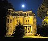 More images | |
| 9 Hangar | 84 North Star Drive, CFB Trenton Quinte West ON | 44°06′54″N 77°32′21″W / 44.1151°N 77.5392°W / 44.1151; -77.5392 (9 Hangar) | Federal (11619) | Upload Photo | |
| 10 Hangar | 52 North Star Drive, CFB Trenton Quinte West ON | 44°06′54″N 77°32′21″W / 44.1151°N 77.5392°W / 44.1151; -77.5392 (10 Hangar) | Federal (11508) | Upload Photo | |
| Building 21 | CFB Trenton Quinte West ON | 44°06′49″N 77°32′39″W / 44.1137°N 77.5441°W / 44.1137; -77.5441 (Building 21) | Federal (11470) | Upload Photo | |
| Building 22 | CFB Trenton Quinte West ON | 44°06′51″N 77°32′55″W / 44.1141°N 77.5486°W / 44.1141; -77.5486 (Building 22) | Federal (11472) | Upload Photo | |
| Building 23 | CFB Trenton Quinte West ON | 44°06′54″N 77°32′20″W / 44.115°N 77.539°W / 44.115; -77.539 (Building 23) | Federal (11509) |  | |
| Building 29 | CFB Trenton Quinte West ON | 44°07′00″N 77°32′59″W / 44.1166°N 77.5498°W / 44.1166; -77.5498 (Building 29) | Federal (10856) | Upload Photo | |
| Building 49 | CFB Trenton Quinte West ON | 44°06′35″N 77°31′55″W / 44.1098°N 77.5320°W / 44.1098; -77.5320 (Building 49) | Federal (11454) | Upload Photo | |
| Building 56 | CFB Trenton Quinte West ON | 44°06′36″N 77°31′45″W / 44.1101°N 77.5291°W / 44.1101; -77.5291 (Building 56) | Federal (11232, (16104) | Upload Photo | |
| Hangar 77 | CFB Trenton Quinte West ON | 44°04′12″N 77°19′59″W / 44.07°N 77.333°W / 44.07; -77.333 (Hangar 77) | Federal (10151) | Upload Photo | |
| Hangar 78 | CFB Trenton Quinte West ON | 44°04′14″N 77°19′56″W / 44.0705°N 77.3322°W / 44.0705; -77.3322 (Hangar 78) | Federal (10155) | Upload Photo | |
| Hangar 80 | CFB Trenton Quinte West ON | 44°04′18″N 77°19′49″W / 44.0718°N 77.3302°W / 44.0718; -77.3302 (Hangar 80) | Federal (10156) | Upload Photo | |
| Hangar 81 | CFB Trenton Quinte West ON | 44°04′18″N 77°19′49″W / 44.0718°N 77.3302°W / 44.0718; -77.3302 (Hangar 81) | Federal (10157) | Upload Photo | |
| Hangar 82 | CFB Trenton Quinte West ON | 44°04′10″N 77°19′54″W / 44.0695°N 77.3316°W / 44.0695; -77.3316 (Hangar 82) | Federal (10159) | Upload Photo | |
| VIP Private Married Quarters | 18 Caribou Crescent, CFB Trenton Quinte West ON | 44°06′31″N 77°31′32″W / 44.1086°N 77.5255°W / 44.1086; -77.5255 (VIP Private Married Quarters) | Federal (11621) | Upload Photo | |
| Lockmaster's House | Sidney ON | 44°07′46″N 77°35′17″W / 44.1294°N 77.5881°W / 44.1294; -77.5881 (Lockmaster's House (Sidney Locks)) | Federal (10517) | 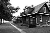 More images | |
| Officers' Mess | CFB Trenton Quinte West ON | 44°06′55″N 77°32′21″W / 44.1152°N 77.5392°W / 44.1152; -77.5392 (Officers' Mess) | Federal (11511) |  | |
| Officer's Quarters | CFB Trenton Quinte West ON | 44°06′55″N 77°32′21″W / 44.1152°N 77.5392°W / 44.1152; -77.5392 (Officer's Quarters) | Federal (11102) | Upload Photo | |
| Trent–Severn Waterway National Historic Site of Canada | Trenton to Severn Quinte West (Trenton) ON | 44°23′09″N 78°27′21″W / 44.3857°N 78.4558°W / 44.3857; -78.4558 (Trent–Severn Waterway National Historic Site of Canada (Quinte West)) | Federal (4507) |  More images | |
| Christ Church, Her Majesty's Chapel Royal of the Mohawk National Historic Site of Canada | South Church Lane Tyendinaga Mohawk Territory ON | 44°11′07″N 77°04′26″W / 44.1854°N 77.0739°W / 44.1854; -77.0739 | Federal (13573) |  More images |
| Name | Address | Coordinates | Government recognition (CRHP №) | Image | |
|---|---|---|---|---|---|
| Canal Lake Concrete Arch Bridge National Historic Site of Canada | Centennial Park Road over the Trent-Severn Waterway Kawartha Lakes ON | 44°33′29″N 79°02′45″W / 44.558°N 79.0459°W / 44.558; -79.0459 (Canal Lake Concrete Arch Bridge) | Federal (13085) |  More images |
| Name | Address | Coordinates | Government recognition (CRHP №) | Image | |
|---|---|---|---|---|---|
| Beausoleil Island National Historic Site of Canada | Georgian Bay Honey Harbour ON | 44°51′58″N 79°52′14″W / 44.8660°N 79.8705°W / 44.8660; -79.8705 (Beausoleil Island National Historic Site of Canada) | Federal (19642) |  More images | |
| Woodchester Villa | 15 King Street Bracebridge ON | 45°02′22″N 79°18′19″W / 45.0394°N 79.3052°W / 45.0394; -79.3052 (Woodchester Villa) | Ontario (8206), Bracebridge municipality (8568) |  More images | |
| Bethune House | 235 John Street Gravenhurst ON | 44°55′14″N 79°22′34″W / 44.9205°N 79.376°W / 44.9205; -79.376 (Bethune House) | Federal (9727) | 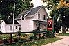 More images | |
| Bethune Memorial House National Historic Site of Canada | 235 John Street North Gravenhurst ON | 44°55′14″N 79°22′34″W / 44.9205°N 79.3761°W / 44.9205; -79.3761 (Bethune Memorial House National Historic Site of Canada) | Federal (7765) | More images | |
| Huntsville CNR Station | 1 Station Road Huntsville ON | 45°19′25″N 79°13′34″W / 45.3237°N 79.2262°W / 45.3237; -79.2262 (Huntsville CNR Station) | Federal (6811), Ontario (10507) |  More images | |
| Western Islands Lighthouse | Double Top Island District Municipality of Muskoka ON | 45°02′12″N 80°21′16″W / 45.0367°N 80.3544°W / 45.0367; -80.3544 (Western Islands Lighthouse) | Federal (21074) |  |
| Name | Address | Coordinates | Government recognition (CRHP №) | Image | |
|---|---|---|---|---|---|
| Barnum House | Alnwick/Haldimand ON | 43°59′26.9″N 78°2′37.0″W / 43.990806°N 78.043611°W / 43.990806; -78.043611 (Barnum House) | Federal (4027), Ontario (19799) | Q4409745 |  More images |
| Former Canadian National Railways (VIA Rail) Station | 201 Third Street Cobourg ON | 43°58′03″N 78°10′17″W / 43.9676°N 78.1714°W / 43.9676; -78.1714 (Former Canadian National Railways (VIA Rail) Station (Cobourg)) | Federal (4617) |  More images | |
| Old Market Building | 201 Third Street Cobourg ON | 43°57′34″N 78°10′04″W / 43.9595°N 78.1679°W / 43.9595; -78.1679 (Old Market Building) | Ontario (8184) | 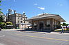 More images | |
| Poplars | 18 Spencer Street East Cobourg ON | 43°57′54″N 78°10′09″W / 43.9651°N 78.1691°W / 43.9651; -78.1691 (Poplars) | Ontario (8897) | 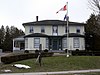 | |
| Second Street Fire Hall | 213 Second Street Cobourg ON | 43°57′34″N 78°10′04″W / 43.9595°N 78.1679°W / 43.9595; -78.1679 (Second Street Fire Hall) | Ontario (10570) |  More images | |
| Victoria College | 100 University Street East Cobourg ON | 43°57′55″N 78°09′53″W / 43.9654°N 78.1646°W / 43.9654; -78.1646 (Victoria College) | Ontario (8208) | Upload Photo | |
| Victoria Hall / Cobourg Town Hall National Historic Site of Canada | 55 King Street Cobourg ON | 43°57′34″N 78°10′04″W / 43.9595°N 78.1679°W / 43.9595; -78.1679 (Victoria Hall / Cobourg Town Hall National Historic Site of Canada) | Federal (7550), Ontario (8201) | 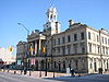 More images | |
| 26 Barrett Street | 26 Barrett Street Port Hope ON | 43°57′15″N 78°17′43″W / 43.9541°N 78.2954°W / 43.9541; -78.2954 (26 Barrett Street) | Port Hope municipality (9329) | 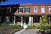 | |
| 34-46 Walton Street, Port Hope | 34 Walton Street Port Hope ON | 43°57′05″N 78°17′35″W / 43.9513°N 78.2931°W / 43.9513; -78.2931 (34-46 Walton Street, Port Hope) | Ontario (8836) |  More images | |
| 50 John Street | 50 John Street Port Hope ON | 43°57′03″N 78°17′42″W / 43.9508°N 78.2949°W / 43.9508; -78.2949 (50 John Street) | Ontario (8266) |  More images | |
| Armstrong Cottage | 239 Ridout Street Port Hope ON | 43°57′05″N 78°18′13″W / 43.9515°N 78.3035°W / 43.9515; -78.3035 (Armstrong Cottage) | Port Hope municipality (9327) |  | |
| Bank of Upper Canada | 86 John Street Port Hope ON | 43°56′59″N 78°17′43″W / 43.9496°N 78.2952°W / 43.9496; -78.2952 (Bank of Upper Canada) | Port Hope municipality (9328) |  More images | |
| Blackham's Hotel | 4345 Dorset Street West Port Hope ON | 43°56′54″N 78°17′45″W / 43.9483°N 78.2957°W / 43.9483; -78.2957 (Blackham's Hotel) | Port Hope municipality (8945) |  | |
| Bluestone House a.k.a. John David Smith House | 21 Dorset Street East Port Hope ON | 43°56′59″N 78°17′23″W / 43.9498°N 78.2898°W / 43.9498; -78.2898 (Bluestone House a.k.a. John David Smith House) | Ontario (19801), Port Hope municipality (8343) |  | |
| Cassie Cottage | 15 Julia Street Port Hope ON | 43°57′09″N 78°18′15″W / 43.9525°N 78.3043°W / 43.9525; -78.3043 (Cassie Cottage) | Port Hope municipality (8946) |  | |
| Chalk Carriage Works | 46 Cavan Street Port Hope ON | 43°57′13″N 78°17′44″W / 43.9537°N 78.2956°W / 43.9537; -78.2956 (Chalk Carriage Works) | Port Hope municipality (9331) |  More images | |
| Charles Clemes Duplex | 57 King Street Port Hope ON | 43°57′03″N 78°17′25″W / 43.9507°N 78.2902°W / 43.9507; -78.2902 (Charles Clemes Duplex) | Port Hope municipality (9332) | 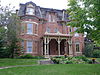 More images | |
| Charles Wickett House | 55 King Street Port Hope ON | 43°57′03″N 78°17′25″W / 43.9508°N 78.2902°W / 43.9508; -78.2902 (Charles Wickett House) | Port Hope municipality (9993) | 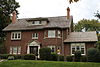 More images | |
| Crawley House | 28 Bedford Street Port Hope ON | 43°57′22″N 78°17′54″W / 43.9562°N 78.2984°W / 43.9562; -78.2984 (Crawley House) | Port Hope municipality (9994) | 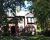 | |
| David Smart House | 175 Dorset Street West Port Hope ON | 43°56′47″N 78°18′08″W / 43.9463°N 78.3021°W / 43.9463; -78.3021 (David Smart House) | Port Hope municipality (7789) | 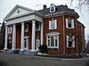 | |
| Elias Smith House | 168 King Street Port Hope ON | 43°56′42″N 78°17′24″W / 43.9449°N 78.290°W / 43.9449; -78.290 (Elias Smith House) | Port Hope municipality (9995) | Upload Photo | |
| Fairmont: The David Smith House | 172 Dorset Street Port Hope ON | 43°57′09″N 78°16′48″W / 43.9524°N 78.28°W / 43.9524; -78.28 (Fairmont: The David Smith House) | Port Hope municipality (9997) | 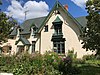 | |
| George Manning Furby House | 61 Bramley Street North Port Hope ON | 43°57′14″N 78°18′26″W / 43.9539°N 78.3073°W / 43.9539; -78.3073 (George Manning Furby House) | Port Hope municipality (9998) |  More images | |
| Henry Howard Meredith House | 47 Pine Street South Port Hope ON | 43°57′01″N 78°17′46″W / 43.9502°N 78.2961°W / 43.9502; -78.2961 (Henry Howard Meredith House) | Port Hope municipality (10002) | 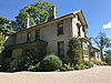 | |
| Hooey Cottage | 20 Ward Street (accessed from 31A Harcourt St.) Port Hope ON | 43°57′14″N 78°17′28″W / 43.9539°N 78.2911°W / 43.9539; -78.2911 (Hooey Cottage) | Port Hope municipality (10003) |  | |
| James Leslie Cottage | 118 Bruton Street Port Hope ON | 43°57′13″N 78°18′21″W / 43.9535°N 78.3057°W / 43.9535; -78.3057 (James Leslie Cottage) | Port Hope municipality (10004) | 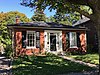 | |
| James Sculthorp Townhouse | 200 Walton Street Port Hope ON | 43°57′08″N 78°18′03″W / 43.9523°N 78.3007°W / 43.9523; -78.3007 (James Sculthorp Townhouse) | Port Hope municipality (10006) |  | |
| John, Ontario and Queen Street Heritage Conservation District | John, Ontario and Queen Street Heritage Conservation District Port Hope ON | 43°57′04″N 78°17′35″W / 43.9512°N 78.2931°W / 43.9512; -78.2931 (John, Ontario and Queen Street Heritage Conservation District) | Port Hope municipality (10001) | Upload Photo | |
| John Tucker Williams House: Penryn Homestead | 82 Victoria Street South Port Hope ON | 43°56′46″N 78°18′21″W / 43.9461°N 78.3058°W / 43.9461; -78.3058 (John Tucker Williams House: Penryn Homestead) | Port Hope municipality (9999) | Upload Photo | |
| Joseph Clarke House | 13 King Street Port Hope ON | 43°57′12″N 78°17′25″W / 43.9534°N 78.2904°W / 43.9534; -78.2904 (Joseph Clarke House) | Port Hope municipality (10007) |  | |
| Judson A. Brown House | 82 Augusta Street Port Hope ON | 43°56′58″N 78°17′52″W / 43.9494°N 78.2979°W / 43.9494; -78.2979 (Judson A. Brown House) | Port Hope municipality (10008) |  | |
| Little Bluestone | 117 King Street Port Hope ON | 43°56′50″N 78°17′24″W / 43.9473°N 78.29°W / 43.9473; -78.29 (Little Bluestone) | Port Hope municipality (8318) |  More images | |
| Little Station | 10 Hayward Street Port Hope ON | 43°56′45″N 78°17′42″W / 43.9459°N 78.2949°W / 43.9459; -78.2949 (Little Station) | Port Hope municipality (10009) | Upload Photo | |
| Margaret and Charles Stuart House | 180 Dorset Street East Port Hope ON | 43°57′13″N 78°16′32″W / 43.9535°N 78.2755°W / 43.9535; -78.2755 (Margaret and Charles Stuart House) | Port Hope municipality (15583) | 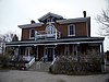 | |
| Penstowe | 98 Ontario Street Port Hope ON | 43°57′22″N 78°17′34″W / 43.9561°N 78.2928°W / 43.9561; -78.2928 (Penstowe) | Port Hope municipality (8342) |  More images | |
| Pinehurst | 44 Pine Street North Port Hope ON | 43°57′15″N 78°17′56″W / 43.9542°N 78.2990°W / 43.9542; -78.2990 (Pinehurst) | Port Hope municipality (10010) | Upload Photo | |
| Port Hope Capitol Theatre | 14 Queen Street Port Hope ON | 43°57′02″N 78°17′35″W / 43.9506°N 78.2931°W / 43.9506; -78.2931 (Port Hope Capitol Theatre) | Port Hope municipality (7788) |  More images | |
| Port Hope CNR Station | 20 Hayward Street Port Hope ON | 43°56′39″N 78°17′52″W / 43.9442°N 78.2979°W / 43.9442; -78.2979 (Port Hope CNR Station) | Federal (4553), Ontario (8898) |  More images | |
| Port Hope Registry Office | 17 Mill Street North Port Hope ON | 43°57′04″N 78°17′31″W / 43.9512°N 78.2919°W / 43.9512; -78.2919 (Port Hope Registry Office) | Port Hope municipality (10011) |  More images | |
| Port Hope Town Hall | 56 Queen Street Port Hope ON | 43°56′57″N 78°17′35″W / 43.9491°N 78.293°W / 43.9491; -78.293 (Port Hope Town Hall) | Port Hope municipality (10012) |  More images | |
| Richard Trick Cottage | 254 Ridout Street Port Hope ON | 43°57′05″N 78°18′15″W / 43.9515°N 78.3043°W / 43.9515; -78.3043 (Richard Trick Cottage) | Port Hope municipality (10013) | 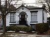 | |
| Robert Mitchell House | 8 King Street Port Hope ON | 43°57′13″N 78°17′27″W / 43.9537°N 78.2907°W / 43.9537; -78.2907 (Robert Mitchell House) | Port Hope municipality (10014) | 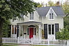 More images | |
| Robert Youdan Terrace | 46 Baldwin Street Port Hope ON | 43°57′12″N 78°18′05″W / 43.9532°N 78.3014°W / 43.9532; -78.3014 (Robert Youdan Terrace) | Port Hope municipality (10015) | Upload Photo | |
| St. Lawrence Hall Block | 87 Walton Street Port Hope ON | 43°57′06″N 78°17′41″W / 43.9516°N 78.2948°W / 43.9516; -78.2948 (St. Lawrence Hall Block) | Ontario (8274) | 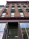 More images | |
| St. Mark's Anglican Church | 51 King Street Port Hope ON | 43°57′05″N 78°17′25″W / 43.9515°N 78.2904°W / 43.9515; -78.2904 (St. Mark's Anglican Church) | Port Hope municipality (9964) |  More images | |
| Smith Cottage | 72 Augusta Street Port Hope ON | 43°56′58″N 78°17′50″W / 43.9495°N 78.2973°W / 43.9495; -78.2973 (Smith Cottage) | Port Hope municipality (9961) | 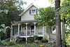 More images | |
| Smith House | 92 King Street Port Hope ON | 43°56′56″N 78°17′25″W / 43.9489°N 78.2902°W / 43.9489; -78.2902 (Smith House) | Port Hope municipality (9962) |  | |
| Thomas B. Chalk House | 48 Bloomsgrove Avenue Port Hope ON | 43°57′26″N 78°17′29″W / 43.9572°N 78.2915°W / 43.9572; -78.2915 (Thomas B. Chalk House) | Port Hope municipality (9966) | Upload Photo | |
| Thomas Clarke House: The Cone | 115 Dorset Street West Port Hope ON | 43°56′50″N 78°17′58″W / 43.9473°N 78.2995°W / 43.9473; -78.2995 (Thomas Clarke House: The Cone) | Port Hope municipality (9967) | 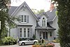 More images | |
| Thomas McCreery House | 78 Augusta Street Port Hope ON | 43°56′58″N 78°17′52″W / 43.9494°N 78.2977°W / 43.9494; -78.2977 (Thomas McCreery House) | Port Hope municipality (9968) | 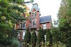 More images | |
| Thomas White House | 22 Shortt Street Port Hope ON | 43°56′59″N 78°18′42″W / 43.9497°N 78.3116°W / 43.9497; -78.3116 (Thomas White House) | Port Hope municipality (9969) | Upload Photo | |
| Turner House | 73 Mill Street South Port Hope ON | 43°56′52″N 78°17′29″W / 43.9478°N 78.2914°W / 43.9478; -78.2914 (Turner House) | Port Hope municipality (9971) | Upload Photo | |
| Union Cemetery Chapel | 114 Toronto Road Port Hope ON | 43°57′21″N 78°19′01″W / 43.9559°N 78.317°W / 43.9559; -78.317 (Union Cemetery Chapel) | Port Hope municipality (8317) | Upload Photo | |
| Waddell Block | 1 Waddell Street Port Hope ON | 43°57′02″N 78°17′31″W / 43.9505°N 78.2919°W / 43.9505; -78.2919 (Waddell Block) | Port Hope municipality (9973) |  More images | |
| Walton Street Heritage Conservation District, Downtown Port Hope | Walton Street, between Pine Street and Mill Street Port Hope ON | 43°57′02″N 78°17′31″W / 43.9505°N 78.2919°W / 43.9505; -78.2919 (Walton Street Heritage Conservation District, Downtown Port Hope) | Port Hope municipality (7792) | Upload Photo | |
| William B. Cawthorne House | 64 Augusta Street Port Hope ON | 43°56′59″N 78°17′48″W / 43.9496°N 78.2968°W / 43.9496; -78.2968 (William B. Cawthorne House) | Port Hope municipality (9974) |  More images | |
| William Bellamy Cottage | 64 Charles Street Port Hope ON | 43°57′09″N 78°18′18″W / 43.9525°N 78.3051°W / 43.9525; -78.3051 (William Bellamy Cottage) | Port Hope municipality (9975) | Upload Photo | |
| William Craig House | 42 Bedford Street Port Hope ON | 43°57′22″N 78°17′58″W / 43.956°N 78.2995°W / 43.956; -78.2995 (William Craig House) | Port Hope municipality (9976) | Upload Photo | |
| William Sisson House: Wimbourne | 89 Dorset Street West Port Hope ON | 43°56′52″N 78°17′52″W / 43.9477°N 78.2979°W / 43.9477; -78.2979 (William Sisson House: Wimbourne) | Port Hope municipality (9972) | 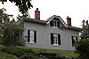 More images | |
| William Skitch Cottage | 159 Bruton Street Port Hope ON | 43°57′10″N 78°18′31″W / 43.9528°N 78.3086°W / 43.9528; -78.3086 (William Skitch Cottage) | Port Hope municipality (9977) | Upload Photo | |
| William Trick Cottage | 9 Church Street Port Hope ON | 43°57′08″N 78°18′07″W / 43.9523°N 78.302°W / 43.9523; -78.302 (William Trick Cottage) | Port Hope municipality (9978) | Upload Photo |
| Name | Address | Coordinates | Government recognition (CRHP №) | Image | |
|---|---|---|---|---|---|
| Pointe-au-Baril Lighthouse | The Archipelago (Pointe au Baril) ON | Federal (9821) |  More images | ||
| Lighttower; Jones Island Front Range | Gordon Rock Carling ON | 45°18′54″N 80°16′50″W / 45.3151°N 80.2806°W / 45.3151; -80.2806 (Lighttower; Jones Island Front Range) | Federal (21065) | Upload Photo | |
| Lighttower; Jones Island Rear Range | West side of Jones Island Carling ON | 45°18′02″N 80°15′21″W / 45.3006°N 80.2557°W / 45.3006; -80.2557 (Lighttower; Jones Island Rear Range) | Federal (21066) | Upload Photo | |
| Snug Harbour Rear Range Light Tower | southern tip of Snug Island Carling ON | 45°22′26″N 80°18′40″W / 45.374°N 80.311°W / 45.374; -80.311 (Snug Harbour Rear Range Light Tower) | Federal (15955) |  | |
| Commanda General Store | 4077 Highway 522 Nipissing (Commanda) ON | 45°57′06″N 79°36′19″W / 45.9516°N 79.6053°W / 45.9516; -79.6053 (Commanda General Store) | Ontario (10425) | Upload Photo | |
| Belvedere Heights Lookout | Belvedere Parry Sound ON | 45°20′33″N 80°02′23″W / 45.3426°N 80.0397°W / 45.3426; -80.0397 (Belvedere Heights Lookout) | Parry Sound municipality (18530) | Upload Photo | |
| Canadian Pacific Railway Station | 1 Avenue Road Parry Sound ON | Federal (7094) | Upload Photo | ||
| Lighttower; Byng Inlet Front Range | Parry Sound ON | 45°45′08″N 80°38′41″W / 45.7521°N 80.6447°W / 45.7521; -80.6447 (Lighttower; Byng Inlet Front Range) | Federal (21068) | Upload Photo | |
| Rear Range Light Tower | Badgeley Island Parry Sound ON | 45°33′21″N 80°29′08″W / 45.5558°N 80.4856°W / 45.5558; -80.4856 (Rear Range Light Tower) | Federal (13216, (13059) | Upload Photo | |
| Lighttower: Lighthouse Shoal | On a shoal in northern Lake Rousseau Seguin ON | 45°14′46″N 79°38′13″W / 45.2460°N 79.6370°W / 45.2460; -79.6370 (Lighttower: Lighthouse Shoal) | Federal (19681) | Upload Photo | |
| Lighthouse and Dwelling | Gereaux Island Unorganized Centre Parry Sound District ON | 45°44′40″N 80°39′33″W / 45.7444°N 80.6591°W / 45.7444; -80.6591 (Lighthouse and Dwelling) | Federal (9678) | 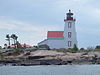 More images | |
| Red Rock Light Tower | Red Rock Island Unorganized Centre Parry Sound District ON | 45°21′39″N 80°23′50″W / 45.3608°N 80.3971°W / 45.3608; -80.3971 (Red Rock Light Tower) | Federal (13214) |  |
| Name | Address | Coordinates | Government recognition (CRHP №) | Image | |
|---|---|---|---|---|---|
| Canadian Pacific Railway Station | Ottawa Street (Hwy No. 7 at Orange St.) Havelock ON | 44°26′00″N 77°52′58″W / 44.4332°N 77.8828°W / 44.4332; -77.8828 (Canadian Pacific Railway Station) | Federal (6701) |  More images | |
| Peterborough Petroglyphs National Historic Site of Canada | Petroglyphs Provincial Park Otonabee–South Monaghan ON | 44°36′46″N 78°02′34″W / 44.6128°N 78.0427°W / 44.6128; -78.0427 (Peterborough Petroglyphs National Historic Site of Canada) | Federal (11705) |  More images | |
| Serpent Mounds National Historic Site of Canada | Roach's Point and East Sugar Island in Rice Lake Otonabee–South Monaghan ON | 44°12′57″N 78°08′34″W / 44.2157°N 78.1428°W / 44.2157; -78.1428 (Serpent Mounds National Historic Site of Canada) | Federal (14407) |  | |
| Absalom Ingram House | 309 Engleburn Avenue Peterborough ON | 44°18′12″N 78°18′45″W / 44.3032°N 78.3126°W / 44.3032; -78.3126 (Absalom Ingram House) | Peterborough municipality (2155) |  More images | |
| Auburn Mills Cottage | 205 Lisburn Street Peterborough ON | 44°19′27″N 78°18′41″W / 44.3242°N 78.3114°W / 44.3242; -78.3114 (Auburn Mills Cottage) | Peterborough municipality (6378) |  More images | |
| Bonner Worth Mill Administration Building | 544 McDonnel Street Peterborough ON | 44°18′30″N 78°20′11″W / 44.3083°N 78.3365°W / 44.3083; -78.3365 (Bonner Worth Mill Administration Building) | Peterborough municipality (4054) |  More images | |
| Burnham Mansion | 760 Lansdowne Street East Peterborough ON | 44°17′46″N 78°16′39″W / 44.296°N 78.2774°W / 44.296; -78.2774 (Burnham Mansion) | Peterborough municipality (1386) | Upload Photo | |
| Cathedral of St. Peter-in-Chains | 316 Hunter Street West Peterborough ON | 44°18′20″N 78°19′39″W / 44.3056°N 78.3276°W / 44.3056; -78.3276 (Cathedral of St. Peter-in-Chains) | Peterborough municipality (1566) |  More images | |
| Central School | 90 Murray Street Peterborough ON | 44°18′31″N 78°19′04″W / 44.3085°N 78.3177°W / 44.3085; -78.3177 (Central School) | Peterborough municipality (7607) | Upload Photo | |
| Confederation Park | 501 George Street North Peterborough ON | 44°18′31″N 78°19′15″W / 44.3086°N 78.3208°W / 44.3086; -78.3208 (Confederation Park) | Peterborough municipality (1664) |  More images | |
| Cox Terrace National Historic Site of Canada | 332-344 Rubidge Street Peterborough ON | 44°18′13″N 78°19′35″W / 44.3036°N 78.3265°W / 44.3036; -78.3265 (Cox Terrace National Historic Site of Canada) | Federal (1188) |  More images | |
| The Dixon-Stevenson-Bradburn Building | 379 George Street North Peterborough ON | 44°18′19″N 78°19′13″W / 44.3052°N 78.3203°W / 44.3052; -78.3203 (The Dixon-Stevenson-Bradburn Building) | Peterborough municipality (6388) | 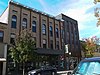 More images | |
| Dumble-Hinton House | 607 Stewart Street Peterborough ON | 44°18′44″N 78°19′35″W / 44.3123°N 78.3264°W / 44.3123; -78.3264 (Dumble-Hinton House) | Peterborough municipality (1558) | Upload Photo | |
| Eastland House | 273 Hunter Street West Peterborough ON | 44°18′21″N 78°19′30″W / 44.3057°N 78.3251°W / 44.3057; -78.3251 (Eastland House) | Peterborough municipality (7609) | 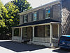 More images | |
| Engleburn House | 260 Engleburn Avenue Peterborough ON | 44°18′08″N 78°18′47″W / 44.3023°N 78.3131°W / 44.3023; -78.3131 (Engleburn House) | Peterborough municipality (1334) |  More images | |
| Fair-Bierk Building | 383 George Street North Peterborough ON | 44°18′19″N 78°19′13″W / 44.3054°N 78.3203°W / 44.3054; -78.3203 (Fair-Bierk Building) | Peterborough municipality (1391) |  More images | |
| Former Peterborough Post Office and Customs Building | 191 201 Charlotte Street Peterborough ON | 44°18′11″N 78°19′19″W / 44.303°N 78.3219°W / 44.303; -78.3219 (Former Peterborough Post Office and Customs Building) | Peterborough municipality (5531) |  More images | |
| George Street United Church | 534 George Street Peterborough ON | 44°18′36″N 78°19′11″W / 44.3099°N 78.3197°W / 44.3099; -78.3197 (George Street United Church) | Peterborough municipality (1564) |  More images | |
| Grover-Nicholls House | 415 Rubidge Street Peterborough ON | 44°18′22″N 78°19′39″W / 44.3062°N 78.3275°W / 44.3062; -78.3275 (Grover-Nicholls House) | Peterborough municipality (1552) |  More images | |
| Hamilton Carriage House | 478 Downie Street Peterborough ON | 44°18′28″N 78°19′44″W / 44.3078°N 78.329°W / 44.3078; -78.329 (Hamilton Carriage House) | Peterborough municipality (6389) | Upload Photo | |
| Harstone House | 565 Water Street Peterborough ON | 44°18′40″N 78°19′11″W / 44.3111°N 78.3196°W / 44.3111; -78.3196 (Harstone House) | Peterborough municipality (1326) |  More images | |
| Hay-Smit House | 155 Hunter Street East Peterborough ON | 44°18′24″N 78°18′26″W / 44.3068°N 78.3071°W / 44.3068; -78.3071 (Hay-Smit House) | Peterborough municipality (5549) |  More images | |
| Henry Calcutt House | 73 Robinson Street Peterborough ON | 44°18′15″N 78°18′37″W / 44.3042°N 78.3103°W / 44.3042; -78.3103 (Henry Calcutt House) | Peterborough municipality (1369) |  More images | |
| Henry Myers Cottage | 538 Harvey Street Peterborough ON | 44°18′37″N 78°19′04″W / 44.3102°N 78.3178°W / 44.3102; -78.3178 (Henry Myers Cottage) | Peterborough municipality (1547) |  More images | |
| Hutchison House | 270 Brock Street Peterborough ON | 44°18′26″N 78°19′31″W / 44.3072°N 78.3252°W / 44.3072; -78.3252 (Hutchison House) | Peterborough municipality (1329) | 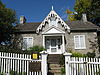 More images | |
| James Menzies House | 279 Sherbrooke Street Peterborough ON | 44°18′01″N 78°19′30″W / 44.3004°N 78.3251°W / 44.3004; -78.3251 (James Menzies House) | Peterborough municipality (3021) | 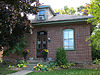 More images | |
| James Miller House | 565-569 Harvey Street Peterborough ON | 44°18′40″N 78°19′06″W / 44.3112°N 78.3184°W / 44.3112; -78.3184 (James Miller House) | Peterborough municipality (1348) |  More images | |
| James Reid House | 1154 Armour Road Peterborough ON | 44°20′21″N 78°18′26″W / 44.3392°N 78.3073°W / 44.3392; -78.3073 (James Reid House) | Peterborough municipality (1557) | Upload Photo | |
| John Britton House | 533 Harvey Street Peterborough ON | 44°18′36″N 78°19′06″W / 44.3101°N 78.3183°W / 44.3101; -78.3183 (John Britton House) | Peterborough municipality (3020) | Upload Photo | |
| The Lundy Building | 285 George Street North Peterborough ON | 44°18′08″N 78°19′12″W / 44.3023°N 78.32°W / 44.3023; -78.32 (The Lundy Building) | Peterborough municipality (6387) |  More images | |
| Malcolm House | 488 Aylmer Street Peterborough ON | 44°18′31″N 78°19′24″W / 44.3085°N 78.3233°W / 44.3085; -78.3233 (Malcolm House) | Peterborough municipality (2145) | Upload Photo | |
| Malone | 62 Dunlop Street Peterborough ON | 44°19′13″N 78°18′45″W / 44.3204°N 78.3124°W / 44.3204; -78.3124 (Malone) | Peterborough municipality (1580) |  More images | |
| Marchbanks | 361 Park Street North Peterborough ON | 44°18′15″N 78°19′48″W / 44.3041°N 78.3301°W / 44.3041; -78.3301 (Marchbanks) | Peterborough municipality (1498) | 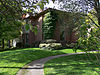 More images | |
| Market Hall and Clock Tower | 360 George Street Peterborough ON | 44°18′15″N 78°19′11″W / 44.3042°N 78.3196°W / 44.3042; -78.3196 (Market Hall and Clock Tower) | Peterborough municipality (1345) |  More images | |
| Merino | 17 Merino Road Peterborough ON | 44°18′14″N 78°21′23″W / 44.3038°N 78.3563°W / 44.3038; -78.3563 (Merino) | Peterborough municipality (8436) | Upload Photo | |
| Morrow Building | 442-448 George Street North Peterborough ON | 44°18′26″N 78°19′12″W / 44.3073°N 78.3199°W / 44.3073; -78.3199 (Morrow Building) | Peterborough municipality (1546) |  More images | |
| Old Pump House | 1230 Water Street Peterborough ON | 44°20′31″N 78°18′42″W / 44.3419°N 78.3117°W / 44.3419; -78.3117 (Old Pump House) | Peterborough municipality (1389) | 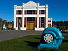 More images | |
| Pagoda Bridge | 610 Parkhill Road West Peterborough ON | 44°18′39″N 78°20′28″W / 44.3109°N 78.341°W / 44.3109; -78.341 (Pagoda Bridge) | Peterborough municipality (1645) |  More images | |
| Pappas Building | 407-409 George Street North Peterborough ON | 44°18′22″N 78°19′13″W / 44.3061°N 78.3203°W / 44.3061; -78.3203 (Pappas Building) | Peterborough municipality (7793) | 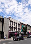 More images | |
| Peck House | 183 Mark Street Peterborough ON | 44°18′01″N 78°18′33″W / 44.3003°N 78.3093°W / 44.3003; -78.3093 (Peck House) | Peterborough municipality (1548) | 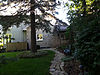 More images | |
| Peterborough CPR Station | 175 George Street North Peterborough ON | 44°17′55″N 78°19′12″W / 44.2987°N 78.3201°W / 44.2987; -78.3201 (Peterborough CPR Station) | Federal (4400), Ontario (8883) |  More images | |
| Peterborough Drill Hall / Armoury | 220 Murray Street Peterborough ON | 44°18′30″N 78°19′14″W / 44.3083°N 78.3206°W / 44.3083; -78.3206 (Peterborough Drill Hall / Armoury) | Federal (4340, (7647) |  More images | |
| Peterborough Family YMCA | 475 George Street North Peterborough ON | 44°18′29″N 78°19′14″W / 44.308°N 78.3206°W / 44.308; -78.3206 (Peterborough Family YMCA) | Peterborough municipality (1556) | 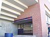 More images | |
| Peterborough Lift Lock National Historic Site of Canada | Otonabee River near Ashburnham Memorial Park Peterborough ON | 44°18′27″N 78°18′01″W / 44.3076°N 78.3004°W / 44.3076; -78.3004 (Peterborough Lift Lock National Historic Site of Canada) | Federal (11449) | 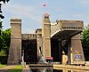 More images | |
| The Pines | 266 Burnham Street Peterborough ON | 44°18′09″N 78°18′41″W / 44.3024°N 78.3115°W / 44.3024; -78.3115 (The Pines) | Peterborough municipality (1394) |  More images | |
| Pioneer Park | 51 Hilliard Street Peterborough ON | 44°19′19″N 78°19′05″W / 44.322°N 78.318°W / 44.322; -78.318 (Pioneer Park) | Peterborough municipality (1587) | 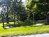 More images | |
| Robert Graham House | 547 Water Street Peterborough ON | 44°18′38″N 78°19′10″W / 44.3105°N 78.3195°W / 44.3105; -78.3195 (Robert Graham House) | Peterborough municipality (1371) |  More images | |
| Sadleir House | 751 George Street North Peterborough ON | 44°18′42″N 78°05′41″W / 44.3118°N 78.0947°W / 44.3118; -78.0947 (Sadleir House) | Peterborough municipality (6377) |  More images | |
| St. John the Evangelist Anglican Church | 118 Hunter Street Peterborough ON | 44°18′24″N 78°19′05″W / 44.3068°N 78.3181°W / 44.3068; -78.3181 (St. John the Evangelist Anglican Church) | Ontario (10580), Peterborough municipality (1346) | 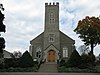 More images | |
| St. Peter's Bishop's Palace | 350 Hunter Street West Peterborough ON | 44°18′21″N 78°19′43″W / 44.3058°N 78.3287°W / 44.3058; -78.3287 (St. Peter's Bishop's Palace) | Peterborough municipality (1579) |  More images | |
| St. Peter's Cathedral Centre | 317 Hunter Street West Peterborough ON | 44°18′20″N 78°19′39″W / 44.3056°N 78.3276°W / 44.3056; -78.3276 (St. Peter's Cathedral Centre) | Peterborough municipality (1559) | 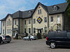 More images | |
| St. Peter's Rectory | 411 Reid Street Peterborough ON | 44°18′21″N 78°19′42″W / 44.3059°N 78.3283°W / 44.3059; -78.3283 (St. Peter's Rectory) | Peterborough municipality (1581) | 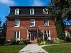 More images | |
| Smithtown Hill House | 269 Edinburgh Street Peterborough ON | 44°18′46″N 78°19′31″W / 44.3129°N 78.3254°W / 44.3129; -78.3254 (Smithtown Hill House) | Peterborough municipality (1565) |  More images | |
| Sutton-Deyman House | 82 Dublin Street Peterborough ON | 44°18′45″N 78°19′03″W / 44.3124°N 78.3176°W / 44.3124; -78.3176 (Sutton-Deyman House) | Peterborough municipality (1554) |  More images | |
| Verulam | 236 Burnham Street Peterborough ON | 44°18′05″N 78°18′41″W / 44.3015°N 78.3115°W / 44.3015; -78.3115 (Verulam) | Peterborough municipality (1555) | 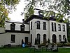 More images | |
| Weller-Boucher House | 548 Weller Street Peterborough ON | 44°18′19″N 78°20′08″W / 44.3052°N 78.3355°W / 44.3052; -78.3355 (Weller-Boucher House) | Peterborough municipality (1620) |  More images | |
| William Blackwell House | 84 Benson Avenue Peterborough ON | 44°19′04″N 78°19′22″W / 44.3178°N 78.3228°W / 44.3178; -78.3228 (William Blackwell House) | Peterborough municipality (1573) | Upload Photo | |
| William Dixon House | 661 Park Street North Peterborough ON | 44°18′47″N 78°20′07″W / 44.3131°N 78.3352°W / 44.3131; -78.3352 (William Dixon House) | Peterborough municipality (1396) | 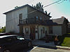 More images | |
| The Yelland Building | 464 George Street North Peterborough ON | 44°18′27″N 78°19′12″W / 44.3074°N 78.3201°W / 44.3074; -78.3201 (The Yelland Building) | Peterborough municipality (5545) |  More images |
| Name | Address | Coordinates | Government recognition (CRHP №) | Image | |
|---|---|---|---|---|---|
| Carrying Place of the Bay of Quinte National Historic Site of Canada | Intersection of the Trenton and Carrying Place Roads Prince Edward (Carrying Place) ON | 44°02′55″N 77°34′57″W / 44.0485°N 77.5825°W / 44.0485; -77.5825 (Carrying Place of the Bay of Quinte National Historic Site of Canada) | Federal (13814) | 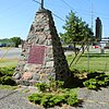 | |
| Lighthouse | Main Duck Island Prince Edward ON | 43°55′52″N 76°38′18″W / 43.9311°N 76.6384°W / 43.9311; -76.6384 (Lighthouse) | Federal (4747) | Upload Photo | |
| Scotch Bonnet Island Lighthouse | Egg Island aka Scotch Bonnet Island Prince Edward ON | 43°53′57″N 77°32′32″W / 43.8993°N 77.5422°W / 43.8993; -77.5422 (Scotch Bonnet Island Lighthouse) | Federal (20774) | Upload Photo | |
| False Duck Island Lighttower | False Duck Island aka Swetman Island Prince Edward ON | 43°56′52″N 76°47′55″W / 43.9478°N 76.7986°W / 43.9478; -76.7986 (False Duck Island Lighttower) | Federal (21073) | Upload Photo |
| Name | Address | Coordinates | Government recognition (CRHP №) | Image | |
|---|---|---|---|---|---|
| Canadian National Railways Allandale Station at Barrie | 285 Bradford Street Barrie ON | 44°22′26″N 79°41′17″W / 44.374°N 79.688°W / 44.374; -79.688 (Canadian National Railways Allandale Station at Barrie) | Federal (6503), Ontario (8884) |  More images | |
| Barrie Public Library | 37 Mulcaster Street Barrie ON | 44°23′24″N 79°41′07″W / 44.39°N 79.6853°W / 44.39; -79.6853 (Barrie Public Library) | Barrie municipality (1370) | 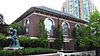 More images | |
| Master Mechanic's Building | 205 Lakeshore Drive Barrie ON | 44°22′26″N 79°40′49″W / 44.374°N 79.6804°W / 44.374; -79.6804 (Master Mechanic's Building) | Barrie municipality (1331) |  More images | |
| Mulcaster Street Armoury | 36 Mulcaster Street Barrie ON | 44°23′24″N 79°41′08″W / 44.39°N 79.6855°W / 44.39; -79.6855 (Mulcaster Street Armoury) | Barrie municipality (1332) | 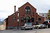 More images | |
| Fort Sainte Marie II National Historic Site of Canada | southern shore of Christian Island Christian Island 30A ON | 44°49′26″N 80°09′51″W / 44.8239°N 80.1642°W / 44.8239; -80.1642 (Fort Sainte Marie II National Historic Site of Canada) | Federal (16002) |  | |
| Tower | Northern tip of Hope Island Christian Island ON | 44°49′26″N 80°09′51″W / 44.8239°N 80.1642°W / 44.8239; -80.1642 (Tower) | Federal (9658) | Upload Photo | |
| Claverleigh National Historic Site of Canada | 3.2 km west of Creemore Clearview ON | 44°19′00″N 80°06′00″W / 44.3167°N 80.1°W / 44.3167; -80.1 (Claverleigh National Historic Site of Canada) | Federal (7597) | Upload Photo | |
| Collingwood Heritage Conservation District | the historic town core of Collingwood Collingwood ON | 44°29′31″N 80°12′22″W / 44.492°N 80.2061°W / 44.492; -80.2061 (Collingwood Heritage Conservation District) | Collingwood municipality (1325) | 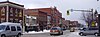 More images | |
| Federal Building | 44 Hurontario Street Collingwood ON | 44°30′05″N 80°13′02″W / 44.5015°N 80.2171°W / 44.5015; -80.2171 (Federal Building) | Federal (3405) | Upload Photo | |
| Lighttower | Nottawasaga Island Collingwood ON | 44°32′19″N 80°15′34″W / 44.5386°N 80.2594°W / 44.5386; -80.2594 (Lighttower) | Federal (3405) | Upload Photo | |
| Barrie Armoury | Park Street Essa ON | 44°23′26″N 79°41′17″W / 44.3905°N 79.6881°W / 44.3905; -79.6881 (Barrie Armoury) | Federal (9580) |  More images | |
| Building A-74 (Maple Mess) | 51 Maple Leaf Drive, CFB Borden Essa ON | 44°16′04″N 79°54′24″W / 44.2678°N 79.9066°W / 44.2678; -79.9066 (Building A-74 (Maple Mess)) | Federal (9556) | Upload Photo | |
| Building A-78 | CFB Borden Essa ON | 44°15′57″N 79°54′15″W / 44.2658°N 79.9042°W / 44.2658; -79.9042 (Building A-78) | Federal (10523) | Upload Photo | |
| Building E-108 | 18 Waterloo Road, CFB Borden Essa ON | 44°17′11″N 79°53′23″W / 44.2864°N 79.8897°W / 44.2864; -79.8897 (Building E-108) | Federal (11497) | Upload Photo | |
| Building O-102 | CFB Borden Essa ON | 44°16′46″N 79°53′32″W / 44.2794°N 79.8922°W / 44.2794; -79.8922 (Building O-102) | Federal (10880) | Upload Photo | |
| Building O-109 (NCO Building) | CFB Borden Essa ON | 44°10′23″N 79°32′02″W / 44.173°N 79.534°W / 44.173; -79.534 (Building O-109 (NCO Building)) | Federal (9600) | Upload Photo | |
| Building P-148 (School) | CFB Borden Essa ON | 44°10′15″N 79°31′33″W / 44.1708°N 79.5259°W / 44.1708; -79.5259 (Building P-148 (School)) | Federal (9589) | Upload Photo | |
| Building S-136 | CFB Borden Essa ON | 44°17′32″N 79°53′51″W / 44.2921°N 79.8975°W / 44.2921; -79.8975 (Building S-136) | Federal (10879) | Upload Photo | |
| Croil Hall (Building A142) | CFB Borden Essa ON | 44°16′26″N 79°53′28″W / 44.2739°N 79.8912°W / 44.2739; -79.8912 (Croil Hall (Building A142)) | Federal (9477) | Upload Photo | |
| Hangar 3 at Hangar Line | Hangar Road, CFB Borden Essa ON | 44°16′05″N 79°54′48″W / 44.2681°N 79.9133°W / 44.2681; -79.9133 (Hangar 3 at Hangar Line) | Federal (16485) | Upload Photo | |
| Hangar 5 at Hangar Line | Hangar Road, CFB Borden Essa ON | 44°16′10″N 79°56′25″W / 44.2695°N 79.9402°W / 44.2695; -79.9402 (Hangar 5 at Hangar Line) | Federal (16486) | Upload Photo | |
| Hangar 6 at Hangar Line | Hangar Road, CFB Borden Essa ON | 44°16′26″N 79°53′28″W / 44.2739°N 79.8912°W / 44.2739; -79.8912 (Hangar 6 at Hangar Line) | Federal (16483) | Upload Photo | |
| Hangar 7 at Hangar Line | Hangar Road, CFB Borden Essa ON | 44°16′05″N 79°54′48″W / 44.2681°N 79.9133°W / 44.2681; -79.9133 (Hangar 7 at Hangar Line) | Federal (16487) | Upload Photo | |
| Hangar 10 at Hangar Line | Hangar Road, CFB Borden Essa ON | 44°16′26″N 79°53′28″W / 44.2739°N 79.8912°W / 44.2739; -79.8912 (Hangar 10 at Hangar Line) | Federal (16488) | Upload Photo | |
| Hangar 11 at Hangar Line | Hangar Road, CFB Borden Essa ON | 44°16′05″N 79°54′48″W / 44.2681°N 79.9133°W / 44.2681; -79.9133 (Hangar 11 at Hangar Line) | Federal (16489) | Upload Photo | |
| Hangar 12 at Hangar Line | Hangar Road, CFB Borden Essa ON | 44°16′26″N 79°53′28″W / 44.2739°N 79.8912°W / 44.2739; -79.8912 (Hangar 12 at Hangar Line) | Federal (16484) | Upload Photo | |
| Hangar 13 at Hangar Line | Hangar Road, CFB Borden Essa ON | 44°16′26″N 79°53′28″W / 44.2739°N 79.8912°W / 44.2739; -79.8912 (Hangar 13 at Hangar Line) | Federal (16490) | Upload Photo | |
| Junior Ranks Quarters (Building T-114) | CFB Borden Essa ON | 44°16′47″N 79°54′02″W / 44.2797°N 79.9005°W / 44.2797; -79.9005 (Junior Ranks Quarters (Building T-114)) | Federal (10147) | Upload Photo | |
| Junior Ranks Quarters (Building T-115) | CFB Borden Essa ON | 44°16′52″N 79°53′59″W / 44.281°N 79.8996°W / 44.281; -79.8996 (Junior Ranks Quarters (Building T-115)) | Federal (10148) | Upload Photo | |
| Royal Flying Corps Hangars National Historic Site of Canada | CFB Borden Essa ON | 44°16′00″N 79°53′00″W / 44.2667°N 79.8833°W / 44.2667; -79.8833 (Royal Flying Corps Hangars National Historic Site of Canada) | Federal (7839) | Upload Photo | |
| Sainte-Marie Among the Hurons Mission National Historic Site of Canada | Highway 12 Midland ON | 44°44′02″N 79°50′25″W / 44.734°N 79.8404°W / 44.734; -79.8404 (Sainte-Marie Among the Hurons Mission National Historic Site of Canada) | Federal (12088) | 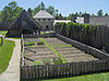 More images | |
| Canadian National Railway Station | 170 Front Street S Orillia ON | 44°36′23″N 79°24′39″W / 44.6064°N 79.4109°W / 44.6064; -79.4109 (Canadian National Railway Station) | Federal (6908) |  More images | |
| Gribbin (McMaster) Building | 45 Mississaga Street East Orillia ON | 44°36′31″N 79°25′07″W / 44.6087°N 79.4186°W / 44.6087; -79.4186 (Gribbin (McMaster) Building) | Orillia municipality (1323) | Upload Photo | |
| Kean's Block | 19-27 Mississaga Street East Orillia ON | 44°36′31″N 79°25′08″W / 44.6085°N 79.419°W / 44.6085; -79.419 (Kean's Block) | Orillia municipality (1324) | 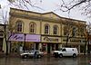 More images | |
| Stephen Leacock Museum / Old Brewery Bay National Historic Site of Canada | 50 Museum Drive Orillia ON | 44°36′30″N 79°23′38″W / 44.6084°N 79.3939°W / 44.6084; -79.3939 (Stephen Leacock Museum / Old Brewery Bay National Historic Site of Canada) | Federal (14362), Ontario (10582) |  More images | |
| Oro African Methodist Episcopal Church National Historic Site of Canada | intersection of the Oro Sideroads 10 and 11 Oro-Medonte ON | 44°30′10″N 79°38′11″W / 44.5027°N 79.6364°W / 44.5027; -79.6364 (Oro African Methodist Episcopal Church National Historic Site of Canada) | Federal (12100) |  More images | |
| Ossossane Sites National Historic Site | Two sites on the shore of Nottawasaga Bay Ossossane Beach ON | Federal (19551) | Upload Photo | ||
| St. James-on-the-Lines Anglican Church | 215 Church Street Penetanguishene ON | 44°47′14″N 79°55′34″W / 44.7871°N 79.9261°W / 44.7871; -79.9261 (St. James-on-the-Lines Anglican Church) | Ontario (10578) |  More images | |
| Trent–Severn Waterway National Historic Site of Canada | Trenton to Port Severn Port Severn ON | 44°23′08″N 78°27′21″W / 44.3856°N 78.4558°W / 44.3856; -78.4558 (Trent–Severn Waterway National Historic Site of Canada (Port Severn)) | Federal (4507) | More images | |
| Mnjikaning Fish Weirs National Historic Site of Canada | bottom of the Narrows between Lakes Simcoe and Couchiching Ramara ON | 44°36′15″N 79°22′11″W / 44.6042°N 79.3696°W / 44.6042; -79.3696 (Mnjikaning Fish Weirs National Historic Site of Canada) | Federal (9679) |  More images | |
| Strawberry Island Combined Lighthouse and Dwelling | Strawberry Island Ramara ON | 45°58′25″N 81°51′15″W / 45.9735°N 81.8542°W / 45.9735; -81.8542 (Strawberry Island Combined Lighthouse and Dwelling) | Federal (12914) | Upload Photo | |
| Glengarry Landing National Historic Site of Canada | Highway 26 Springwater ON | 44°27′03″N 79°54′04″W / 44.4509°N 79.9012°W / 44.4509; -79.9012 (Glengarry Landing National Historic Site of Canada) | Federal (15768) | 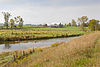 More images | |
| Mission of St. Ignace II National Historic Site of Canada | the west half of Lot 6, Concession 9 Tay ON | 44°43′24″N 79°43′06″W / 44.7232°N 79.7183°W / 44.7232; -79.7183 (Mission of St. Ignace II National Historic Site of Canada) | Federal (14461) |  More images | |
| Saint-Louis Mission National Historic Site of Canada | a tableland beside the Hogg River, 3 km inland from Georgian Bay, near Victoria Harbour Tay ON | 44°43′43″N 79°46′54″W / 44.7285°N 79.7818°W / 44.7285; -79.7818 (Saint-Louis Mission National Historic Site of Canada) | Federal (14403) |  | |
| Brebeuf Island Front Range Light Tower | Brebeuf Island Tiny ON | 44°53′38″N 80°00′45″W / 44.8939°N 80.0125°W / 44.8939; -80.0125 (Brebeuf Island Front Range Light Tower) | Federal (16761) | Upload Photo |


