List of historic places in Regional Municipality of Waterloo
Map all coordinates using OpenStreetMap
Download coordinates as:
- KML
- GPX (all coordinates)
- GPX (primary coordinates)
- GPX (secondary coordinates)
This is a list of historic places in Regional Municipality of Waterloo, Ontario, containing heritage sites listed on the Canadian Register of Historic Places (CRHP), all of which are designated as historic places either locally, provincially, territorially, nationally, or by more than one level of government.
List of historic places
| Name | Address | Coordinates | Government recognition (CRHP №) | Image | |
|---|---|---|---|---|---|
| Armoury | Ainslie Street South Cambridge ON | 43°21′29″N 80°18′49″W / 43.3581°N 80.3137°W / 43.3581; -80.3137 (Armoury) | Federal (4685) |  More images | |
| Black Bridge | 8 Black Bridge Road Cambridge ON | 43°26′58″N 80°18′42″W / 43.4495°N 80.3116°W / 43.4495; -80.3116 (Black Bridge) | Cambridge municipality (10789) |  More images | |
| Cambridge City Hall | 46 Dickson Street Cambridge ON | 43°21′36″N 80°18′46″W / 43.3601°N 80.3127°W / 43.3601; -80.3127 (Cambridge City Hall) | Ontario (7606) | 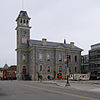 More images | |
| Cambridge Farmer's Market | 40 Dickson Street Cambridge ON | 43°21′36″N 80°18′48″W / 43.3599°N 80.3134°W / 43.3599; -80.3134 (Cambridge Farmer's Market) | Cambridge municipality (9766) |  More images | |
| Cambridge Main Street Bridge | Main Street Cambridge ON | 43°21′32″N 80°19′00″W / 43.3588°N 80.3166°W / 43.3588; -80.3166 (Cambridge Main Street Bridge) | Cambridge municipality (10817) |  | |
| Canadian Pacific Railway Station | 10 Malcolm Street Cambridge ON | 43°22′05″N 80°18′56″W / 43.3680°N 80.3156°W / 43.3680; -80.3156 (Canadian Pacific Railway Station) | Federal (4524) |  More images | |
| Dickson Public School | 65 St. Andrew Street Cambridge ON | 43°21′19″N 80°19′15″W / 43.3554°N 80.3207°W / 43.3554; -80.3207 (Dickson Public School) | Cambridge municipality (10132) |  More images | |
| Duncan Ferguson Homestead | 71 Cowan Boulevard Cambridge ON | 43°23′01″N 80°17′39″W / 43.3836°N 80.2943°W / 43.3836; -80.2943 (Duncan Ferguson Homestead) | Cambridge municipality (10135) |  Upload Photo | |
| First Delta Baptist Church | 47 Water Street Cambridge ON | 43°21′25″N 80°18′54″W / 43.3569°N 80.315°W / 43.3569; -80.315 (First Delta Baptist Church) | Ontario (10487), Cambridge municipality (11221) |  More images | |
| Former Galt Post Office National Historic Site of Canada | 12-1/2 Water Street South Cambridge ON | 43°21′36″N 80°18′54″W / 43.3601°N 80.3151°W / 43.3601; -80.3151 (Former Galt Post Office National Historic Site of Canada) | Federal (13139) | 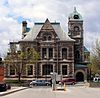 More images | |
| Ferguson Cottage | 37 Grand Avenue South Cambridge ON | 43°21′23″N 80°19′03″W / 43.3565°N 80.3175°W / 43.3565; -80.3175 (Ferguson Cottage) | Cambridge municipality (11218) |  More images | |
| Galt Collegiate Institute | 210 Water Street Cambridge ON | 43°22′09″N 80°19′02″W / 43.3691°N 80.3171°W / 43.3691; -80.3171 (Galt Collegiate Institute) | Cambridge municipality (10092) |  More images | |
| Galt Fire Department Hall | 56 Dickson Street Cambridge ON | 43°21′36″N 80°18′44″W / 43.3599°N 80.3122°W / 43.3599; -80.3122 (Galt Fire Department Hall) | Cambridge municipality (10093) |  | |
| Galt Public Utilities Commission Building | 62 Dickson Street Cambridge ON | 43°21′35″N 80°18′42″W / 43.3598°N 80.3116°W / 43.3598; -80.3116 (Galt Public Utilities Commission Building) | Cambridge municipality (10095) |  More images | |
| Hespeler Town Hall | 11 Tannery Street East Cambridge ON | 43°25′51″N 80°18′34″W / 43.4308°N 80.3095°W / 43.4308; -80.3095 (Hespeler Town Hall) | Cambridge municipality (11634) |  | |
| Landreth Cottage | 84 Water Street South Cambridge ON | 43°21′44″N 80°18′55″W / 43.3623°N 80.3152°W / 43.3623; -80.3152 (Landreth Cottage) | Cambridge municipality (13719) | Upload Photo | |
| Middleton Water Pumping Station | 60 Middleton Street Cambridge ON | 43°20′50″N 80°19′06″W / 43.3471°N 80.3183°W / 43.3471; -80.3183 (Middleton Water Pumping Station) | Cambridge municipality (13720) | 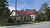 More images | |
| Morris C. Lutz House | 60 Water Street North Cambridge ON | 43°21′41″N 80°18′55″W / 43.3614°N 80.3153°W / 43.3614; -80.3153 (Morris C. Lutz House) | Cambridge municipality (9895) | Upload Photo | |
| Pioneer Pergola | St. Andrews Street Cambridge ON | 43°21′19″N 80°19′15″W / 43.3554°N 80.3207°W / 43.3554; -80.3207 (Pioneer Pergola) | Cambridge municipality (11891) | 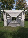 More images | |
| Riverside Park Gates | King Street E. Cambridge ON | 43°24′01″N 80°21′59″W / 43.4004°N 80.3663°W / 43.4004; -80.3663 (Riverside Park Gates) | Cambridge municipality (15304) | Upload Photo | |
| 39 Doon Valley Drive | 39 Doon Valley Drive Kitchener ON | 43°23′23″N 80°24′55″W / 43.3896°N 80.4154°W / 43.3896; -80.4154 (39 Doon Valley Drive) | Kitchener municipality (10685) | 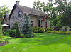 More images | |
| 41 Bloomingdale Road | 41 Bloomingdale Road Kitchener ON | 43°28′54″N 80°28′33″W / 43.4818°N 80.4759°W / 43.4818; -80.4759 (41 Bloomingdale Road) | Kitchener municipality (14882) | Upload Photo | |
| 45 King Street West | 45 King Street West Kitchener ON | 43°27′N 80°29′W / 43.45°N 80.49°W / 43.45; -80.49 (45 King Street West) | Kitchener municipality (15112) | 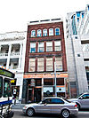 | |
| 150 Water Street South | 150 Water Street South Kitchener ON | 43°26′51″N 80°29′53″W / 43.4476°N 80.498°W / 43.4476; -80.498 (150 Water Street South) | Kitchener municipality (9990) |  More images | |
| 883 Doon Village Road | 883 Doon Village Road Kitchener ON | 43°23′28″N 80°26′24″W / 43.3912°N 80.4399°W / 43.3912; -80.4399 (883 Doon Village Road) | Kitchener municipality (14885) | 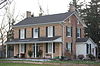 | |
| 307 Queen Street South | 307 Queen Street South Kitchener ON | 43°26′47″N 80°29′33″W / 43.4463°N 80.4926°W / 43.4463; -80.4926 (307 Queen Street South) | Kitchener municipality (10684) |  | |
| 3734 King Street East | 3734 King Street East Kitchener ON | 43°25′15″N 80°24′35″W / 43.4208°N 80.4098°W / 43.4208; -80.4098 (3734 King Street East) | Kitchener municipality (14866) |  | |
| Betzner Farmstead | 437 Pioneer Tower Road Kitchener ON | 43°24′15″N 80°25′11″W / 43.4042°N 80.4196°W / 43.4042; -80.4196 (Betzner Farmstead) | Kitchener municipality (9069) | Upload Photo | |
| Bridgeport Free Church | 76 Bloomingdale Kitchener ON | 43°28′57″N 80°28′25″W / 43.4825°N 80.4735°W / 43.4825; -80.4735 (Bridgeport Free Church) | Kitchener municipality (14981) |  | |
| Canadian Imperial Bank of Commerce (CIBC) Building | 1 King Kitchener ON | 43°26′59″N 80°29′21″W / 43.4496°N 80.4891°W / 43.4496; -80.4891 (Canadian Imperial Bank of Commerce (CIBC) Building) | Kitchener municipality (14965) |  | |
| David Weber House | 69 Biehn Kitchener ON | 43°23′44″N 80°27′19″W / 43.3955°N 80.4554°W / 43.3955; -80.4554 (David Weber House) | Kitchener municipality (15109) | 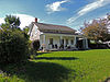 More images | |
| Federal Building | 15 Duke Street Kitchener ON | 43°27′02″N 80°29′16″W / 43.4506°N 80.4877°W / 43.4506; -80.4877 (Federal Building) | Federal (4804) |  More images | |
| Former Canadian National Railways (VIA Rail) Station | 126 Weber Street Kitchener ON | 43°27′22″N 80°29′35″W / 43.456°N 80.493°W / 43.456; -80.493 (Former Canadian National Railways (VIA Rail) Station) | Federal (4571) |  More images | |
| Freeport Bridge | King Street Kitchener ON | 43°25′23″N 80°24′40″W / 43.4231°N 80.411°W / 43.4231; -80.411 (Freeport Bridge) | Kitchener municipality (8068) | 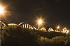 More images | |
| Government of Canada Building | 166 Frederick Street Kitchener ON | 43°27′10″N 80°29′01″W / 43.4527°N 80.4836°W / 43.4527; -80.4836 (Government of Canada Building) | Federal (4268) | Upload Photo | |
| Haalboom Home | 1165 Doon Village Road Kitchener ON | 43°23′20″N 80°25′47″W / 43.3888°N 80.4298°W / 43.3888; -80.4298 (Haalboom Home) | Kitchener municipality (9217) | 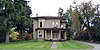 More images | |
| Haas-Pemberton House | 45 Young Street West Kitchener ON | 43°26′51″N 80°29′53″W / 43.4476°N 80.498°W / 43.4476; -80.498 (Haas-Pemberton House) | Kitchener municipality (11023) | Upload Photo | |
| Homer Watson House / Doon School of Fine Arts National Historic Site of Canada | 1754 Old Mill Road Kitchener ON | 43°23′38″N 80°25′02″W / 43.394°N 80.4171°W / 43.394; -80.4171 (Homer Watson House / Doon School of Fine Arts National Historic Site of Canada) | Federal (1143), Ontario (10497), Kitchener municipality (10969) |  More images | |
| Joseph Schneider Haus National Historic Site of Canada | 466 Queen Street South Kitchener ON | 43°26′41″N 80°29′41″W / 43.4446°N 80.4947°W / 43.4446; -80.4947 (Joseph Schneider Haus National Historic Site of Canada) | Federal (1145) |  More images | |
| Kaufman Rubber Company Ltd. | 410 King Street West Kitchener ON | 43°27′09″N 80°29′48″W / 43.4525°N 80.4966°W / 43.4525; -80.4966 (Kaufman Rubber Company Ltd.) | Kitchener municipality (15469) | 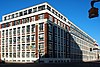 | |
| Public Utilities Commission Building | 191 King Street West Kitchener ON | 43°27′04″N 80°29′34″W / 43.451°N 80.4928°W / 43.451; -80.4928 (Public Utilities Commission Building) | Kitchener municipality (15474) |  | |
| Registry Theatre | 122 Frederick Street Kitchener ON | 43°27′05″N 80°29′10″W / 43.4515°N 80.4861°W / 43.4515; -80.4861 (Registry Theatre) | Kitchener municipality (12427) | 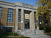 | |
| St. Jerome's College/High School | 120 Duke Street West Kitchener ON | 43°27′08″N 80°29′31″W / 43.4523°N 80.492°W / 43.4523; -80.492 (St. Jerome's College/High School) | Kitchener municipality (15472) | 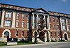 More images | |
| Schoerg Homestead | 381 Pioneer Tower Road Kitchener ON | 43°24′22″N 80°24′33″W / 43.4061°N 80.4092°W / 43.4061; -80.4092 (Schoerg Homestead) | Kitchener municipality (9898) | Upload Photo | |
| Shoemaker House | 38 Shirk Kitchener ON | 43°28′54″N 80°29′09″W / 43.4818°N 80.4859°W / 43.4818; -80.4859 (Shoemaker House) | Kitchener municipality (14964) | Upload Photo | |
| Simpson Block | 117 King Kitchener ON | 43°27′02″N 80°29′29″W / 43.4505°N 80.4914°W / 43.4505; -80.4914 (Simpson Block) | Kitchener municipality (14982) | 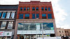 | |
| Sonneck House | 108 Queen Street North Kitchener ON | 43°26′55″N 80°29′25″W / 43.4487°N 80.4904°W / 43.4487; -80.4904 (Sonneck House) | Kitchener municipality (15476) |  | |
| Stauffer Log House | 393 Tilt Kitchener ON | 43°22′38″N 80°26′19″W / 43.3771°N 80.4386°W / 43.3771; -80.4386 (Stauffer Log House) | Kitchener municipality (15111) | Upload Photo | |
| Steckle Homestead | 811 Bleams Road Kitchener ON | 43°24′16″N 80°29′06″W / 43.4045°N 80.485°W / 43.4045; -80.485 (Steckle Homestead) | Kitchener municipality (13245) | Upload Photo | |
| Victoria Public School | 25 Joseph Street Kitchener ON | 43°26′55″N 80°29′31″W / 43.4486°N 80.492°W / 43.4486; -80.492 (Victoria Public School) | Kitchener municipality (15475) |  More images | |
| The Walper Hotel | 20 Queen St South Kitchener ON | 43°26′59″N 80°29′21″W / 43.4497°N 80.4893°W / 43.4497; -80.4893 (The Walper Hotel) | Kitchener municipality (10659) |  | |
| Waterloo County Jail and Governor's House | 73 Queen Street Kitchener ON | 43°27′09″N 80°29′12″W / 43.4525°N 80.4868°W / 43.4525; -80.4868 (Waterloo County Jail and Governor's House) | Kitchener municipality (9216) |  More images | |
| Waterloo Pioneer Memorial Tower | 300 Lookout Lane Kitchener ON | 43°24′00″N 80°24′59″W / 43.4001°N 80.4163°W / 43.4001; -80.4163 (Waterloo Pioneer Memorial Tower) | Federal (3297) | 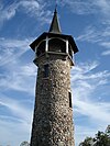 More images | |
| Weber Block | 37 King Kitchener ON | 43°27′00″N 80°29′24″W / 43.4499°N 80.49°W / 43.4499; -80.49 (Weber Block) | Kitchener municipality (14984) | 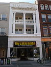 | |
| Williamsburg School | 1385 Bleams Kitchener ON | 43°24′04″N 80°29′57″W / 43.4011°N 80.4992°W / 43.4011; -80.4992 (Williamsburg School) | Kitchener municipality (14985) | Upload Photo | |
| Woodside National Historic Site of Canada | 528 Wellington Street North Kitchener ON | 43°27′49″N 80°28′50″W / 43.4635°N 80.4805°W / 43.4635; -80.4805 (Woodside National Historic Site of Canada) | Federal (12767, (9951) | 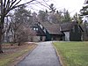 | |
| Woolner Farmstead | 748 Zeller Drive Kitchener ON | 43°27′02″N 80°25′22″W / 43.4505°N 80.4229°W / 43.4505; -80.4229 (Woolner Farmstead) | Kitchener municipality (9047) | Upload Photo | |
| Bahnsen-Bierstock-Marsland House | 47 Albert Waterloo ON | 43°28′00″N 80°31′28″W / 43.4666°N 80.5244°W / 43.4666; -80.5244 (Bahnsen-Bierstock-Marsland House) | Waterloo municipality (14366) | 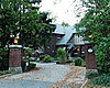 | |
| Bank of Montreal | 3 King Waterloo ON | 43°27′54″N 80°31′21″W / 43.465°N 80.5225°W / 43.465; -80.5225 (Bank of Montreal) | Waterloo municipality (14386) | 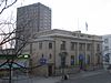 | |
| Bean-Wright House | 73 George Street Waterloo ON | 43°27′50″N 80°31′02″W / 43.4638°N 80.5171°W / 43.4638; -80.5171 (Bean-Wright House) | Waterloo municipality (10782) |  | |
| Burkhardt House | 7 Central Street Waterloo ON | 43°28′11″N 80°31′26″W / 43.4698°N 80.5238°W / 43.4698; -80.5238 (Burkhardt House) | Waterloo municipality (10802) | 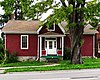 | |
| The Button Factory | 25 Regina Street Waterloo ON | 43°27′50″N 80°31′15″W / 43.4639°N 80.5208°W / 43.4639; -80.5208 (The Button Factory) | Waterloo municipality (14751) | 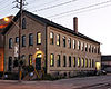 | |
| Charlie Voelker House | 29 Spring Street West Waterloo ON | 43°28′08″N 80°31′34″W / 43.4688°N 80.526°W / 43.4688; -80.526 (Charlie Voelker House) | Waterloo municipality (10901) | 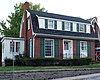 | |
| Elam Martin Farmstead | Woolwich Street Waterloo ON | 43°31′21″N 80°29′42″W / 43.5226°N 80.4951°W / 43.5226; -80.4951 (Elam Martin Farmstead) | Waterloo municipality (8064) | Upload Photo | |
| Elizabeth Ziegler Public School | 90 Moore Avenue South Waterloo ON | 43°27′55″N 80°30′48″W / 43.4653°N 80.5134°W / 43.4653; -80.5134 (Elizabeth Ziegler Public School) | Waterloo municipality (9721) | 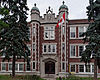 More images | |
| Elsworthy-Elgie House | 88 Fountain Street Waterloo ON | 43°28′09″N 80°31′33″W / 43.4692°N 80.5258°W / 43.4692; -80.5258 (Elsworthy-Elgie House) | Waterloo municipality (11033) |  | |
| Erb-Kumpf House | 172 King Street South Waterloo ON | 43°27′39″N 80°31′12″W / 43.4609°N 80.5201°W / 43.4609; -80.5201 (Erb-Kumpf House) | Waterloo municipality (11185) |  | |
| Good-Shantz-Bosch House | 157 Albert Street Waterloo ON | 43°28′17″N 80°31′46″W / 43.4715°N 80.5294°W / 43.4715; -80.5294 (Good-Shantz-Bosch House) | Waterloo municipality (14749) |  | |
| Hilliard House | 88 William Waterloo ON | 43°27′31″N 80°31′30″W / 43.4585°N 80.5251°W / 43.4585; -80.5251 (Hilliard House) | Waterloo municipality (14446) |  | |
| Huether Hotel | 59 King Street Waterloo ON | 43°28′01″N 80°31′23″W / 43.467°N 80.5231°W / 43.467; -80.5231 (Huether Hotel) | Waterloo municipality (8281) |  More images | |
| J.E. Seagram's Distillery Administration and Maintenance Buildings | 83 Erb Street West Waterloo ON | 43°27′49″N 80°31′37″W / 43.4635°N 80.527°W / 43.4635; -80.527 (J.E. Seagram's Distillery Administration and Maintenance Buildings) | Waterloo municipality (11652) | 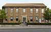 | |
| John E. Brubacher House | Columbia Street West Waterloo ON | 43°28′22″N 80°33′08″W / 43.4727°N 80.5523°W / 43.4727; -80.5523 (John E. Brubacher House) | Waterloo municipality (9893) | Q96374034 | 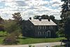 More images |
| Kuntz-Eckert House | 156 King Street South Waterloo ON | 43°27′41″N 80°31′14″W / 43.4615°N 80.5206°W / 43.4615; -80.5206 (Kuntz-Eckert House) | Waterloo municipality (11679) |  | |
| Kuntz-Labatt's House | 167 King Street South Waterloo ON | 43°27′39″N 80°31′13″W / 43.4609°N 80.5204°W / 43.4609; -80.5204 (Kuntz-Labatt's House) | Waterloo municipality (11680) | 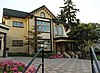 | |
| Market Hotel | 12 Dupont Street Waterloo ON | 43°27′58″N 80°31′25″W / 43.466°N 80.5237°W / 43.466; -80.5237 (Market Hotel) | Waterloo municipality (14750) | 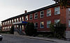 | |
| McLaughlin House | 20 Menno Street Waterloo ON | 43°27′46″N 80°31′43″W / 43.4627°N 80.5286°W / 43.4627; -80.5286 (McLaughlin House) | Waterloo municipality (11824) |  | |
| Mutual Life Assurance Co. of Canada Building | 227 King Street South Waterloo ON | 43°27′31″N 80°30′58″W / 43.4585°N 80.5161°W / 43.4585; -80.5161 (Mutual Life Assurance Co. of Canada Building) | Waterloo municipality (11829) |  | |
| Nixon House | 81 Norman Street Waterloo ON | 43°27′30″N 80°31′25″W / 43.4582°N 80.5237°W / 43.4582; -80.5237 (Nixon House) | Waterloo municipality (11831) |  | |
| The Pumping Station | 17 William Street Waterloo ON | 43°27′42″N 80°30′21″W / 43.4617°N 80.5057°W / 43.4617; -80.5057 (The Pumping Station) | Waterloo municipality (13243) | 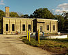 | |
| Reitzel House | 147 Avondale Avenue South Waterloo ON | 43°27′21″N 80°31′24″W / 43.4557°N 80.5232°W / 43.4557; -80.5232 (Reitzel House) | Waterloo municipality (15480) | 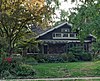 | |
| Richber House | 222 Mary Street Waterloo ON | 43°27′36″N 80°30′59″W / 43.46°N 80.5165°W / 43.46; -80.5165 (Richber House) | Waterloo municipality (12434) | 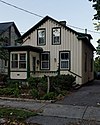 | |
| Rudy-Snyder House | 268 Southampton Place Waterloo ON | 43°26′39″N 80°32′55″W / 43.4441°N 80.5487°W / 43.4441; -80.5487 (Rudy-Snyder House) | Waterloo municipality (14752) | 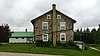 | |
| Rummelhardt School | 600 Erb Street Waterloo ON | 43°26′54″N 80°33′56″W / 43.4483°N 80.5655°W / 43.4483; -80.5655 (Rummelhardt School) | Waterloo municipality (12846) |  | |
| Schiel-Patterson House | 115 William Waterloo ON | 43°27′27″N 80°31′35″W / 43.4576°N 80.5264°W / 43.4576; -80.5264 (Schiel-Patterson House) | Waterloo municipality (14576) | 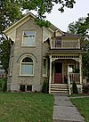 | |
| Snyder-Hahn Building | 4 King Street South Waterloo ON | 43°26′51″N 80°29′53″W / 43.4476°N 80.498°W / 43.4476; -80.498 (Snyder-Hahn Building) | Waterloo municipality (13168) | 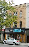 | |
| Snyder-Seagram House | 50 Albert Street Waterloo ON | 43°28′02″N 80°31′30″W / 43.4672°N 80.525°W / 43.4672; -80.525 (Snyder-Seagram House) | Waterloo municipality (11870) | 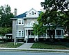 | |
| Voelker House | 36 Young Street West Waterloo ON | 43°28′06″N 80°31′33″W / 43.4682°N 80.5257°W / 43.4682; -80.5257 (Voelker House) | Waterloo municipality (10602) |  | |
| The Waterloo Hotel | 4 King Street Waterloo ON | 43°27′55″N 80°31′21″W / 43.4653°N 80.5224°W / 43.4653; -80.5224 (The Waterloo Hotel) | Waterloo municipality (14747) |  | |
| Waterloo Post Office | 35 King Street North Waterloo ON | 43°27′58″N 80°31′22″W / 43.4661°N 80.5229°W / 43.4661; -80.5229 (Waterloo Post Office) | Waterloo municipality (10594) |  | |
| Waterloo Train Station | 20 Regina Street South Waterloo ON | 43°27′53″N 80°31′16″W / 43.4646°N 80.521°W / 43.4646; -80.521 (Waterloo Train Station) | Waterloo municipality (10593) |  | |
| Wissler House | 438 Malabar Drive Waterloo ON | 43°30′17″N 80°30′00″W / 43.5046°N 80.5001°W / 43.5046; -80.5001 (Wissler House) | Waterloo municipality (10658) | Upload Photo | |
| The Ament-Burrell House | 70 Arthur Road Wellesley ON | 43°31′15″N 80°37′25″W / 43.5208°N 80.6235°W / 43.5208; -80.6235 (The Ament-Burrell House) | Wellesley municipality (15232) | Upload Photo | |
| Forrest House | 2086 Perth Line Wellesley ON | 43°28′44″N 80°49′21″W / 43.4789°N 80.8225°W / 43.4789; -80.8225 (Forrest House) | Wellesley municipality (11627) | Upload Photo | |
| Frenzel-Kuebart House | 3851 Weimar Line Wellesley ON | 43°29′16″N 80°40′24″W / 43.4878°N 80.6733°W / 43.4878; -80.6733 (Frenzel-Kuebart House) | Wellesley municipality (15227) | Upload Photo | |
| Hastings Belmont House | 4862 William Hastings Line Wellesley ON | 43°31′52″N 80°44′32″W / 43.5311°N 80.7423°W / 43.5311; -80.7423 (Hastings Belmont House) | Wellesley municipality (11631) | Upload Photo | |
| Old School | 1137 Henry Street Wellesley ON | 43°28′42″N 80°45′51″W / 43.4784°N 80.7641°W / 43.4784; -80.7641 (Old School) | Wellesley municipality (9896) | 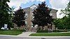 | |
| Queen's Tavern | 1215 Queen's Bush Road Wellesley ON | 43°28′40″N 80°46′02″W / 43.4778°N 80.7673°W / 43.4778; -80.7673 (Queen's Tavern) | Wellesley municipality (12078) | 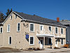 More images | |
| Reiner House | 19 Doering Street Wellesley ON | 43°28′26″N 80°45′50″W / 43.4738°N 80.7638°W / 43.4738; -80.7638 (Reiner House) | Wellesley municipality (15218) |  More images | |
| St. John's Lutheran Church | 4260 Hessen Strasse Wellesley ON | 43°30′32″N 80°42′05″W / 43.5088°N 80.7015°W / 43.5088; -80.7015 (St. John's Lutheran Church) | Wellesley municipality (9722) | 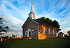 More images | |
| Wellesley Township Hall | 4805 William Hastings Line Wellesley ON | 43°31′51″N 80°44′30″W / 43.5308°N 80.7417°W / 43.5308; -80.7417 (Wellesley Township Hall) | Wellesley municipality (9720) | 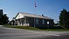 | |
| Baden Hotel | 39 Snyder's Road West Wilmot ON | 43°24′12″N 80°40′14″W / 43.4034°N 80.6705°W / 43.4034; -80.6705 (Baden Hotel) | Wilmot municipality (10080) | 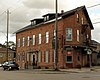 More images | |
| Blue Moon | 1677 Snyder's Road Wilmot ON | 43°24′49″N 80°36′16″W / 43.4135°N 80.6044°W / 43.4135; -80.6044 (Blue Moon) | Wilmot municipality (9989) |  More images | |
| Castle Kilbride | 60 Snyder's Road West Wilmot ON | 43°24′12″N 80°40′17″W / 43.4032°N 80.6714°W / 43.4032; -80.6714 (Castle Kilbride) | Federal (11938), Wilmot municipality (10077) |  More images | |
| Christner House | 1379 Christner Road Wilmot ON | 43°42′47″N 81°05′06″W / 43.7131°N 81.0849°W / 43.7131; -81.0849 (Christner House) | Wilmot municipality (10898) | Upload Photo | |
| Doctor's House | 27 Mill Street Wilmot ON | 43°19′07″N 80°31′50″W / 43.3187°N 80.5306°W / 43.3187; -80.5306 (Doctor's House) | Wilmot municipality (10955) | Upload Photo | |
| The Emporium | 169 Front Street Wilmot ON | 43°21′05″N 80°32′08″W / 43.3515°N 80.5356°W / 43.3515; -80.5356 (The Emporium) | Wilmot municipality (13223) | Upload Photo | |
| Gingerich Property | 1 Shadybrook Court Wilmot ON | 43°22′39″N 80°31′52″W / 43.3775°N 80.5311°W / 43.3775; -80.5311 (Gingerich Property) | Wilmot municipality (10835) | Upload Photo | |
| Hamilton Bank Building | 98 Peel Street, New Hamburg Wilmot ON | 43°22′42″N 80°42′34″W / 43.3782°N 80.7094°W / 43.3782; -80.7094 (Hamilton Bank Building) | Wilmot municipality (11628) | Upload Photo | |
| Henry Killer Farmstead | 2541 Nafziger Road Wilmot ON | 43°24′33″N 80°42′27″W / 43.4091°N 80.7076°W / 43.4091; -80.7076 (Henry Killer Farmstead) | Wilmot municipality (11633) | Upload Photo | |
| Hostetler House | 1145 Christner Road Wilmot ON | 43°23′48″N 80°42′19″W / 43.3966°N 80.7054°W / 43.3966; -80.7054 (Hostetler House) | Wilmot municipality (11650) | Upload Photo | |
| Martini House | 1634 Snyder's Road East Wilmot ON | 43°24′47″N 80°36′25″W / 43.4131°N 80.607°W / 43.4131; -80.607 (Martini House) | Wilmot municipality (11751) | Upload Photo | |
| New Hamburg Heritage Conservation District | Wilmot ON | 43°22′41″N 80°42′34″W / 43.3781°N 80.7095°W / 43.3781; -80.7095 (New Hamburg Heritage Conservation District) | Wilmot municipality (11830) |  More images | |
| Shantz Country Cupboard | 1828 Notre Dame Road Wilmot ON | 43°25′02″N 80°36′33″W / 43.4171°N 80.6091°W / 43.4171; -80.6091 (Shantz Country Cupboard) | Wilmot municipality (12848) | Upload Photo | |
| Wagler Property | 1138 Snyder's Road West Wilmot ON | 43°24′09″N 80°40′38″W / 43.4026°N 80.6773°W / 43.4026; -80.6773 (Wagler Property) | Wilmot municipality (10601) | Upload Photo | |
| Waterlot | 17 Huron Street Wilmot ON | 43°22′42″N 80°42′36″W / 43.3783°N 80.71°W / 43.3783; -80.71 (Waterlot) | Wilmot municipality (9049) | 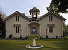 More images | |
| William J. Scott House | 3332 Bleams Road Wilmot ON | 43°22′42″N 80°40′39″W / 43.3782°N 80.6775°W / 43.3782; -80.6775 (William J. Scott House) | Wilmot municipality (9983) | Upload Photo | |
| Zoeller House | 2791 Bleams Road East Wilmot ON | 43°22′35″N 80°41′38″W / 43.3764°N 80.6938°W / 43.3764; -80.6938 (Zoeller House) | Wilmot municipality (10605) | Upload Photo | |
| Bristow's Inn | 80 Arthur Woolwich ON | 43°35′44″N 80°33′39″W / 43.5955°N 80.5609°W / 43.5955; -80.5609 (Bristow's Inn) | Woolwich municipality (14579) | Upload Photo | |
| Conestogo United Church | 1790 Sawmill Road Woolwich ON | 43°32′27″N 80°29′52″W / 43.5409°N 80.4979°W / 43.5409; -80.4979 (Conestogo United Church) | Woolwich municipality (10263) | 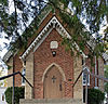 More images | |
| Dunke House | 2 William Street Woolwich ON | 43°36′04″N 80°33′27″W / 43.6011°N 80.5575°W / 43.6011; -80.5575 (Dunke House) | Woolwich municipality (15191) | Upload Photo | |
| Gore Park Bandstand | 68 Arthur Street South Woolwich ON | 43°35′50″N 80°33′36″W / 43.5972°N 80.5601°W / 43.5972; -80.5601 (Gore Park Bandstand) | Woolwich municipality (10933) |  | |
| John B. Snyder House | 24 Queensway Drive Woolwich ON | 43°31′59″N 80°33′21″W / 43.5331°N 80.5558°W / 43.5331; -80.5558 (John B. Snyder House) | Woolwich municipality (11651) | Upload Photo | |
| McDonald House | 13 Katherine Street North Woolwich ON | 43°33′36″N 80°28′07″W / 43.56°N 80.4685°W / 43.56; -80.4685 (McDonald House) | Woolwich municipality (11823) | Upload Photo | |
| Steiner Residence | 1401 King Street Woolwich ON | 43°32′20″N 80°33′13″W / 43.539°N 80.5536°W / 43.539; -80.5536 (Steiner Residence) | Woolwich municipality (13190) | Upload Photo | |
| Swope House | 52 Hill Street Woolwich ON | 43°35′12″N 80°35′12″W / 43.5868°N 80.5868°W / 43.5868; -80.5868 (Swope House) | Woolwich municipality (10053) | Upload Photo | |
| West Montrose Covered Bridge | Covered Bridge Drive Woolwich ON | 43°35′09″N 80°28′54″W / 43.5859°N 80.4818°W / 43.5859; -80.4818 (West Montrose Covered Bridge) | Woolwich municipality (8291) |  More images |
See also
Wikimedia Commons has media related to Cultural heritage monuments in Ontario.
- List of oldest buildings and structures in the Regional Municipality of Waterloo
- List of historic places in Ontario
- List of National Historic Sites of Canada in Ontario


